
Extreme Heat Warnings and Heat Advisories issued from the Central Plains to the Southwest U.S.
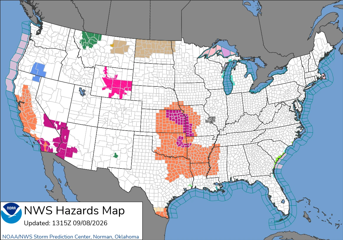
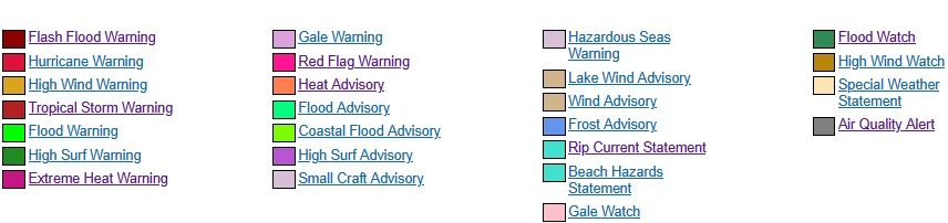
Extreme Heat Warnings and Heat Advisories were issued across parts of the central and southern United States, the Southwest and California on September 8, 2026. The National Weather Service (NWS) forecast heat index values up to 44°C (112°F) in parts of Arkansas and Oklahoma and temperatures up to 47°C (116°F) in Death Valley and the Colorado River Valley, with several western alerts continuing through September 11.

Image credit: MSEMA
- Extreme Heat Warnings and Heat Advisories covered parts of the central and southern United States, the Southwest, and California on September 8, 2026.
- Heat index values were forecast up to 45°C (113°F) in southern Texas and 44°C (112°F) in parts of Arkansas and Oklahoma.
- Western desert temperatures were forecast up to 47°C (116°F), with several alerts continuing through September 11.
- WPC forecast some relief east of the Rocky Mountains late September 9, while prolonged heat continued across the southern Plains.
The Weather Prediction Center (WPC) Short Range Forecast Discussion, issued at 07:58 UTC on September 8 and valid through 12:00 UTC on September 10, forecast dangerous heat from the central Plains into the mid-Mississippi Valley through Wednesday.
Daytime highs were expected to reach the upper 30s°C (upper 90s°F) and locally exceed 38°C (100°F). A cold front associated with a Canadian low-pressure system was forecast to bring some temperature relief east of the Rocky Mountains late Wednesday.
Temperatures were also forecast to rise across the western United States as an upper-level low departed and atmospheric heights increased. WPC’s Extended Forecast Discussion, issued at 06:42 UTC on September 8, maintained upper-level ridging across the southern tier and forecast the prolonged heat wave to continue across the southern Plains through the weekend.
Many alerts across the central and southern United States were scheduled to expire during the evening of September 8. Some western alerts were already in effect, while others were scheduled to begin on September 9 or 10 and continue through September 11.
NWS San Diego, California
NWS San Diego issued Extreme Heat Warnings and Heat Advisories across its forecast area. A warning for the Coachella Valley, San Diego County deserts and San Gorgonio Pass was scheduled from 10:00 PDT (17:00 UTC) on September 9 through 20:00 PDT on September 11 (03:00 UTC on September 12), with highs of 41–43°C (106–110°F).
Extreme Heat Warnings remained in effect through 20:00 PDT on September 9 (03:00 UTC on September 10) for the Orange and San Diego County coastal areas, Orange County inland areas, San Diego County valleys and the San Bernardino and Riverside County valleys.
Those areas were scheduled to transition to Heat Advisories through 20:00 PDT on September 10. A separate Heat Advisory covered the Riverside and San Diego County mountains through September 10, while NWS identified Major to Extreme HeatRisk in parts of the forecast area.
NWS Phoenix, Arizona
Extreme Heat Warnings covered the Phoenix metropolitan area and large parts of southwestern Arizona and southeastern California. The Phoenix-area warning remained in effect from 10:00 MST (17:00 UTC) on September 8 through 20:00 MST on September 10 (03:00 UTC on September 11), with temperatures of 41–43°C (105–109°F) and Major HeatRisk.
Warnings for Yuma, Gila Bend, the Tonopah Desert, Gila River Valley, southeastern Yuma County, Kofa and the Sonoran Desert National Monument also continued through September 10, with highs up to 43°C (110°F).
The Imperial Valley and parts of western and southwestern Imperial County were under warnings through 20:00 PDT on September 11, with temperatures of 41–44°C (106–112°F). Warnings for the Parker, La Paz, Chuckwalla and Palo Verde valleys were scheduled to begin at 10:00 local time on September 9 and continue through September 11.
NWS Las Vegas, Nevada
NWS Las Vegas issued an Extreme Heat Warning for parts of southern Nevada, northwestern Arizona and southeastern California from 10:00 to 20:00 local time on September 10 (17:00 UTC to 03:00 UTC on September 11).
The warning covered the Las Vegas, Pahrump, and Moapa valleys, areas around Lake Mead and Lake Mohave, the Colorado River Valley, Death Valley National Park, and surrounding desert zones.
Temperatures were forecast at 44–47°C (112–116°F) in Death Valley and the Colorado River Valley and 41–43°C (105–110°F) in the Las Vegas, Moapa and Pahrump valleys. NWS described the event as dangerously hot late-season conditions.
NWS Kansas City/Pleasant Hill, Missouri
An Extreme Heat Warning covered parts of eastern Kansas and western Missouri, including the Kansas City metropolitan area, through 20:00 CDT on September 8 (01:00 UTC on September 9). Heat index values were forecast to approach 43°C (110°F).
The warning included Atchison, Miami, Linn, Leavenworth, Wyandotte, and Johnson counties in Kansas and Platte, Clay, Jackson, Cass, and Bates counties in Missouri.
A Heat Advisory covered additional parts of northeastern Kansas and northern and central Missouri from 12:00 to 20:00 CDT (17:00 UTC to 01:00 UTC on September 9). Heat index values above 41°C (105°F) were possible.
NWS Topeka, Kansas
An Extreme Heat Warning remained in effect across much of central, eastern and northern Kansas through 19:00 CDT on September 8 (00:00 UTC on September 9).
The warning included Topeka, Lawrence, Manhattan, Junction City, Emporia and Ottawa. NWS Topeka forecast afternoon heat index values of 39–43°C (103–109°F).
NWS Springfield, Missouri
An Extreme Heat Warning covered southeastern Kansas and southwestern and west-central Missouri through 20:00 CDT on September 8 (01:00 UTC on September 9). Heat index values were forecast to reach 42°C (107°F).
The warning included Bourbon, Crawford and Cherokee counties in Kansas and Vernon, St. Clair, Barton, Cedar, Jasper, Dade, Newton, Lawrence, McDonald, Barry and Stone counties in Missouri.
A Heat Advisory covered Benton, Camden, Hickory, Miller, Morgan, Christian, Dallas, Greene, Polk and Taney counties during the same period, with heat index values up to 41°C (105°F).
NWS Tulsa, Oklahoma
NWS Tulsa issued an Extreme Heat Warning for parts of western Arkansas and eastern Oklahoma from 12:00 to 20:00 CDT on September 8 (17:00 UTC to 01:00 UTC on September 9).
The warning included Tulsa, Rogers, Mayes, Okmulgee, Wagoner, Muskogee, McIntosh and Haskell counties and parts of Sebastian, Crawford, Franklin, Le Flore and Sequoyah counties. Heat index values were forecast to reach 44°C (112°F).
Heat Advisories covered additional parts of northwestern and west-central Arkansas and eastern Oklahoma during the same period. Maximum heat index values varied by segment and were forecast at approximately 41–43°C (106–109°F).
NWS Hanford, California
A Heat Advisory covered the San Joaquin Valley, Sierra Nevada foothills and western hills along the Coast Range from 10:00 PDT on September 9 through 22:00 PDT on September 10 (17:00 UTC to 05:00 UTC on September 11).
Fresno, Bakersfield, Hanford, Visalia, Merced, Madera, Porterville, Delano, Coalinga and Los Banos were among the included communities. NWS Hanford forecast highs up to 39°C (102°F), morning lows up to 24°C (75°F), widespread Moderate HeatRisk and localized Major HeatRisk.
NWS Los Angeles/Oxnard, California
A Heat Advisory covered coastal and inland parts of Los Angeles County, including downtown Los Angeles, as well as the San Fernando and San Gabriel valleys, from 10:00 PDT on September 8 through 20:00 PDT on September 10 (17:00 UTC to 03:00 UTC on September 11).
The advisory also included the Malibu Coast, Palos Verdes Hills, Santa Monica Mountains, and Calabasas and Agoura Hills. Temperatures were forecast at 29–41°C (85–105°F), approximately 6–8°C (10–15°F) above normal.
Additional advisories covering parts of San Luis Obispo, Santa Barbara and Ventura counties, including the Cuyama, Santa Clarita, Santa Ynez and Ojai valleys, were scheduled to begin September 9 and continue through September 10.
NWS Sacramento, California
A Heat Advisory covered the central and southern Sacramento Valley, northern San Joaquin Valley, Delta, Carquinez Strait, nearby foothills and parts of the Coast Range from 10:00 PDT on September 9 through 22:00 PDT on September 10 (17:00 UTC to 05:00 UTC on September 11).
Highs were forecast at 36–39°C (97–102°F) and lows at 18–24°C (65–75°F), with widespread Moderate Heat Risk and localized Major Heat Risk. The hottest conditions and largest areas of Major Heat Risk were forecast on September 10.
NWS San Francisco, California
NWS San Francisco issued a Heat Advisory for the Bay Area and Central Coast from 10:00 PDT on September 9 through 22:00 PDT on September 10 (17:00 UTC to 05:00 UTC on September 11).
The advisory covered the Bay shoreline, North Bay, San Francisco Peninsula, East Bay, Santa Cruz Mountains, Santa Clara Valley, Salinas Valley and parts of Monterey and San Benito counties. Temperatures were forecast at 6–11°C (10–20°F) above normal, increasing risks for people without effective cooling or adequate hydration.
NWS Memphis, Tennessee
A Heat Advisory covered parts of eastern Arkansas, northern Mississippi and western Tennessee from 11:00 to 20:00 CDT on September 8 (16:00 UTC to 01:00 UTC on September 9).
The advisory included the Memphis metropolitan area and surrounding counties, with heat index values forecast up to 43°C (109°F).
NWS Brownsville, Texas
A Heat Advisory covered inland parts of Cameron, Kenedy and Willacy counties and northern and southern Hidalgo and Starr counties from 12:00 to 18:00 CDT on September 8 (17:00–23:00 UTC).
Brownsville, Harlingen, McAllen, Edinburg, Mission, Weslaco and Rio Grande City were among the included communities. Heat index values were forecast up to 45°C (113°F).
NWS Wichita, Kansas
A Heat Advisory remained in effect across parts of central, eastern and southern Kansas through 20:00 CDT on September 8 (01:00 UTC on September 9).
The advisory included the Wichita area and portions of central, south-central and southeastern Kansas. Heat index values were forecast up to 41°C (105°F).
NWS Jackson, Mississippi
A Heat Advisory covered parts of southeastern Arkansas, northeastern Louisiana and central and western Mississippi from 11:00 to 19:00 CDT on September 8 (16:00 UTC to 00:00 UTC on September 9).
The advisory included the Mississippi Delta, Jackson metropolitan area and adjacent parts of Louisiana and Arkansas. Heat index values were forecast up to 43°C (110°F).
NWS Norman, Oklahoma
A Heat Advisory remained in effect across much of Oklahoma and parts of northern Texas through 19:00 CDT on September 8 (00:00 UTC on September 9).
Oklahoma City, Norman, Lawton, Stillwater, Ponca City, Altus and Wichita Falls were among the included communities. Heat index values were forecast up to 42°C (108°F), with overnight temperatures remaining around 24–26°C (75–79°F).
NWS Hastings, Nebraska
A Heat Advisory covered Jewell, Mitchell, Osborne, Rooks and Smith counties in Kansas and Nuckolls and Thayer counties in Nebraska from 12:00 to 19:00 CDT on September 8 (17:00 UTC to 00:00 UTC on September 9).
Heat index values were forecast at 41–43°C (105–109°F).
NWS Dodge City, Kansas
A Heat Advisory covered Ellis, Rush, Barber, Comanche, Edwards, Kiowa, Pawnee, Pratt and Stafford counties from 12:00 to 20:00 CDT on September 8 (17:00 UTC to 01:00 UTC on September 9).
Hays, Pratt, Larned, Kinsley and Medicine Lodge were among the included communities. Heat index values were forecast up to 41°C (105°F).
NWS St. Louis, Missouri
NWS St. Louis issued a Heat Advisory for Boone, Cole and Moniteau counties, including Columbia and Jefferson City, from 12:00 to 20:00 CDT on September 8 (17:00 UTC to 01:00 UTC on September 9).
Heat index values were forecast up to 42°C (107°F).
NWS Little Rock, Arkansas
A Heat Advisory covered much of central, eastern and western Arkansas from 11:00 to 20:00 CDT on September 8 (16:00 UTC to 01:00 UTC on September 9).
Little Rock, North Little Rock, Hot Springs, Pine Bluff, Russellville, Conway, Camden, Monticello and Mena were among the included communities. Heat index values were forecast up to 43°C (109°F).
NWS Fort Worth, Texas
Heat Advisories covered a broad part of North Texas through 20:00 CDT on September 8 (01:00 UTC on September 9).
The primary advisory area included Dallas, Tarrant, Denton, Collin, Grayson, Wise, Cooke, Hunt, Rockwall, Kaufman, Ellis, Johnson, Navarro and Henderson counties. Separate segments covered Fannin and Lamar counties and areas farther south around Waco, Temple and Palestine.
Maximum heat index values varied by segment and were forecast at approximately 41–42°C (106–108°F).
NWS Shreveport, Louisiana
A Heat Advisory covered parts of south-central and southwestern Arkansas, northern Louisiana, southeastern Oklahoma and eastern Texas from 10:00 to 19:00 CDT on September 8 (15:00 UTC to 00:00 UTC on September 9).
The advisory included Shreveport-Bossier City, Texarkana, Tyler, Longview, Lufkin, Nacogdoches, Monroe, Ruston and El Dorado. Heat index values were forecast up to 43°C (109°F).
NWS Omaha/Valley, Nebraska
A Heat Advisory covered parts of southwestern Iowa and southeastern Nebraska from 13:00 to 19:00 CDT on September 8 (18:00 UTC to 00:00 UTC on September 9).
The advisory included Mills, Montgomery, Fremont, and Page counties in Iowa and Lancaster, Cass, Otoe, Saline, Jefferson, Gage, Johnson, Nemaha, Pawnee, and Richardson counties in Nebraska. Heat index values were forecast up to 42°C (108°F).
References:
1 Heat Warning – NOAA/NWS – September 8, 2026
2 Heat advisory – NOAA/NWS – September 8, 2026

Rishav Kothari is Editor-in-Chief of The Watchers, where he runs the newsroom and covers earthquakes, volcanoes, severe weather and space weather.
Published in the last 24 hours
- Forecasters say this winter’s El Niño could reach historic strength, but the last one that big, nicknamed Godzilla in 2015–16, left Los Angeles with about two-thirds of its normal rain while storms pounded the Pacific Northwest Epicenter
- Winds circling the North Pole have slowed sharply this month, the same kind of disruption that in January 2019 split the polar vortex and sent Chicago to minus 23°F, cold enough that rail crews ran flames along the tracks Epicenter
- In April 2014, golden-winged warblers in the mountains of Tennessee, songbirds weighing about as much as four dimes, fled their breeding grounds a day or two before a tornado outbreak and flew hundreds of miles south, while the scientists tracking them sheltered in a Waffle House Epicenter
- After record Nordic heatwave, Swedish researchers to recreate indoor heat to study older adults Epicenter
