
Hurricane Lowell weakens to Category 4 after briefly regaining Category 5, Hawaii under State of Emergency
Hurricane Lowell reached Category 5 strength with winds of 260 km/h (160 mph) before weakening slightly to Category 4 south of Hawaii late on Friday, September 4, 2026. Heavy rainfall, life-threatening surf and possible wind and storm-surge impacts remained forecast for portions of the state through early next week, particularly around Kauaʻi County.

Satellite image Category 5 hurricane Lowell at 08:30 UTC September 5, 2026. Credit: NOAA/GOES-18, RAMMB/CIRA, The Watchers
Hurricane Lowell regained Category 5 strength south of Hawaii at 17:00 HST on Friday, September 4 (03:00 UTC on September 5), with maximum sustained winds of 260 km/h (160 mph), before weakening slightly to Category 4 six hours later.
At 23:00 HST, Lowell had winds of 250 km/h (155 mph) and was moving west ahead of a forecast sharp northward turn that could bring it close to the western Hawaiian Islands late Monday.
Lowell’s minimum central pressure was 922 hPa when it regained Category 5 intensity. At that time, its center was approximately 990 km (615 miles) south-southwest of Līhuʻe, Kauaʻi.
By 23:00 HST on Friday (09:00 UTC on Saturday), Lowell was centered approximately 1 000 km (625 miles) south-southwest of Līhuʻe and 985 km (610 miles) south-southwest of Honolulu.
The hurricane was moving west at 11 km/h (7 mph). Hurricane-force winds extended up to 95 km (60 miles) from the center, while tropical-storm-force winds extended up to 260 km (160 miles).
Data from an Air Force Reserve Hurricane Hunter aircraft showed that Lowell’s central pressure had risen to 925 hPa (27.32 inHg) and its maximum 700 hPa flight-level winds had decreased to 261 km/h (162 mph), reported as 141 knots. These observations supported lowering the estimated surface intensity to 250 km/h (155 mph), making Lowell a Category 4 hurricane.
Satellite imagery continued to show a warm eye surrounded by a generally symmetrical eyewall. However, the eye had become slightly more ragged and less clearly defined, while cloud tops had warmed slightly within the eastern part of the eyewall.
Lowell was forecast to continue generally westward through Saturday while gradually slowing. A mid- to upper-level low moving south to southeast north of Hawaii was expected to weaken the subtropical ridge and cause Lowell to turn sharply north or north-northeast on Sunday.
The forecast track would bring the hurricane close to the westernmost main Hawaiian Islands on Monday and Monday night. Forecasters cautioned that uncertainty remained over exactly where and how sharply Lowell would turn.
Environmental conditions were expected to remain favorable for Lowell to maintain much of its strength during the following 12–24 hours. The official forecast allowed for Lowell to regain Category 5 intensity, with maximum sustained winds of 260 km/h (160 mph), during that period.
A gradual weakening trend was then forecast as vertical wind shear increased and Lowell began drawing dry mid-level air into its circulation. The rate of weakening was expected to increase by Monday as the wind shear became substantially stronger.
Despite the forecast weakening, Lowell was expected to remain near major-hurricane strength when it moved close to the western Hawaiian Islands late Monday and Monday night.
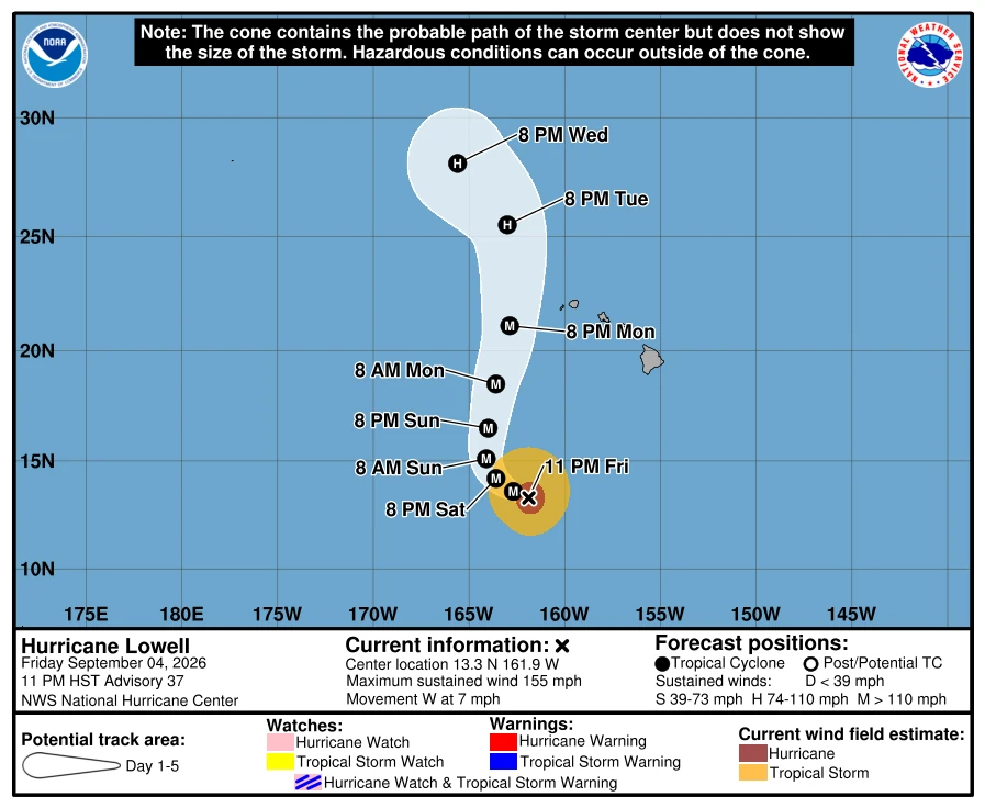
No coastal watches or warnings were in effect at 23:00 HST on September 4. However, the Central Pacific Hurricane Center/National Hurricane Center said watches could be required for portions of the westernmost Hawaiian Islands on Saturday.
Forecasters identified a risk of wind and storm-surge impacts across portions of Hawaii, particularly Kauaʻi County, early next week. The location and severity of any impacts will depend on Lowell’s exact track, intensity and wind-field size as it turns northward.
Heavy rainfall associated with Lowell was forecast to begin affecting the Hawaiian Islands on Sunday afternoon and continue into early next week. Periods of heavy rain could produce flash flooding and mudslides, particularly in steep terrain.
Forecast rainfall totals across Kauaʻi and Hawaiʻi Island were 76–152 mm (3–6 inches), with localized amounts exceeding 254 mm (10 inches). Maui was forecast to receive 51–102 mm (2–4 inches), with isolated totals near 203 mm (8 inches).
The remaining islands could receive 25–51 mm (1–2 inches), with localized totals near 102 mm (4 inches).
Swells generated by Lowell were expected to produce life-threatening surf and rip-current conditions across many of the Hawaiian Islands during the following several days. These swells were forecast to increase further early next week.
The National Weather Service in Honolulu said southerly swells from Lowell were already maintaining advisory-level surf along exposed shorelines. South-facing surf on Kauaʻi and Oʻahu was forecast at 2.4–3.7 m (8–12 feet).
Lowell’s swell was expected to shift from south to southwest, potentially producing extra-large surf above warning thresholds along southern and western exposures early next week. Monthly high tides could compound impacts around harbor entrances, channels, coastal properties, infrastructure and roads.
East-facing surf was also elevated, but the National Weather Service attributed that component to swell generated by Hurricane Karina rather than Lowell.
Hawaiʻi Governor Josh Green signed a statewide emergency proclamation on September 3 covering preparations for Lowell, Hurricane Karina, Tropical Storm Marie and any additional storms that could affect the state.
Six high-water vehicles were being sent to Kauaʻi, while Hawaiʻi National Guard personnel could be activated to support civilian authorities and disaster-relief operations.
The proclamation activated the Major Disaster Fund and allowed state and county agencies to mobilize personnel, equipment, and emergency resources more rapidly. It also authorized measures to protect utilities and other critical infrastructure.
The emergency relief period remains in effect through November 1 unless terminated or superseded. The proclamation did not order evacuations, impose a curfew, or close schools, businesses, or government offices.
Reference:
1 Governor Green declares State of Emergency and pre-positions resources ahead of tropical cyclones — State of Hawaiʻi Office of the Governor — September 3, 2026
2 Hurricane Lowell Advisory Number 36 — NOAA/NWS/CPHC — September 5, 2026
3 Hurricane Lowell Forecast Discussion Number 36 — NOAA/NWS/CPHC — September 5, 2026

Rishav Kothari is Editor-in-Chief of The Watchers, where he runs the newsroom and covers earthquakes, volcanoes, severe weather and space weather.
Published in the last 24 hours
- Second nationwide US flight halt since 9/11: how the November 13 FAA ground stop compares with September 2001 and January 2023 Epicenter
- FAA grounds all departing flights across the US after communications outage hits air traffic control centers nationwide
- In September 1859, a solar storm lit up the night sky so brightly that gold miners in the Rocky Mountains woke up after midnight and started cooking breakfast, convinced the aurora glowing over their camp was the sunrise Epicenter
- A patch of warm Pacific water that could become the strongest El Niño in more than 70 years sits thousands of miles from any American town, yet it is already the main reason NOAA expects a wetter winter across the South and a milder one across the North
