Eye of extremely dangerous Category 4 Hurricane “Beryl” moves over Carriacou Island, Grenada
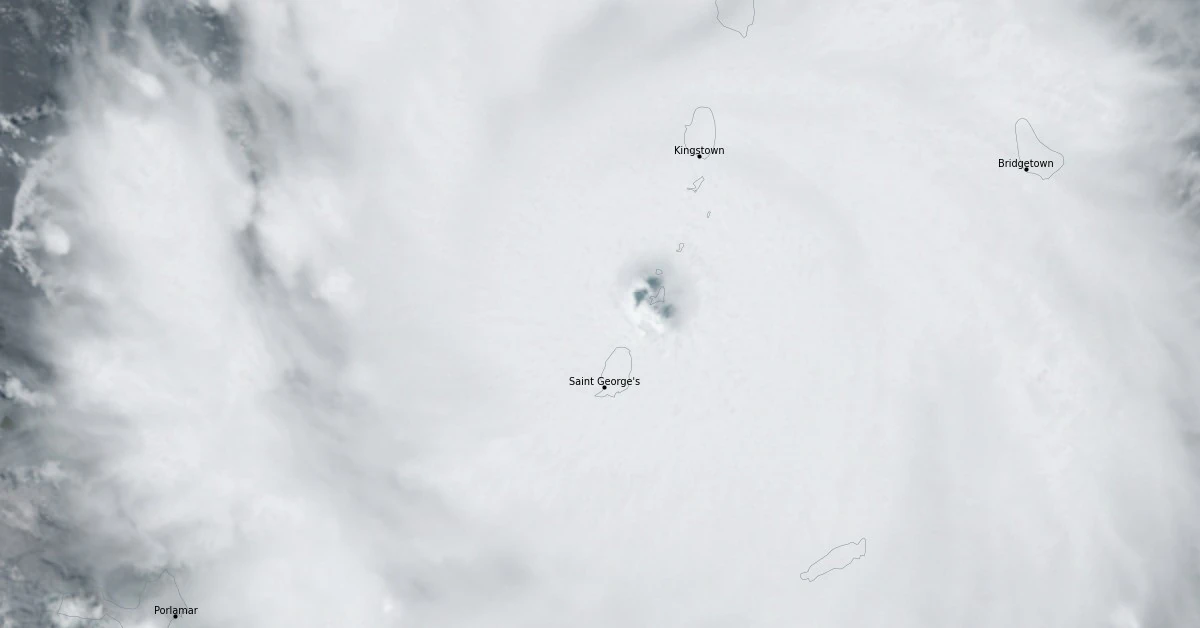
Hurricane “Beryl” restrengthened into a Category 4 hurricane on July 1, 2024, as it approached the Windward Islands. As of 14:00 UTC, its center was located about 75 km (50 miles) E of Grenada and 40 km (25 miles) ESE of Carriacou Island. At 14:50 UTC, Beryl’s eyewall started moving over Carriacou Island.
- The eye of extremely dangerous Category 4 Hurricane “Beryl” moved between Scarborough, Trinidad and Tobago, and Speightstown, Barbados on its way toward Carriacou (population 9 600), Grenada.
- Beryl is on track to be the strongest hurricane to hit the southernmost Windward Islands on record and the most intense for the area since Hurricane “Ivan” 20 years ago.
Beryl is nearing the southern Windward Islands and is expected to make landfall within the next hour or two, the National Hurricane Center (NHC) said at 14:00 UTC.
“This is an extremely dangerous and life-threatening situation. Take action now to protect your life,” NHC forecasters said.
“Residents in the Grenadine Islands and Carriacou Island should not leave their shelter as winds will rapidly increase within the eyewall of Beryl. Remain in place through the passage of these life-threatening conditions and do not venture out in the eye of the storm.”
A weather station located in Barbados at Grantley Adams International Airport recently reported a sustained wind of 83 km/h (52 mph) and a gust of 111 km/h (69 mph).
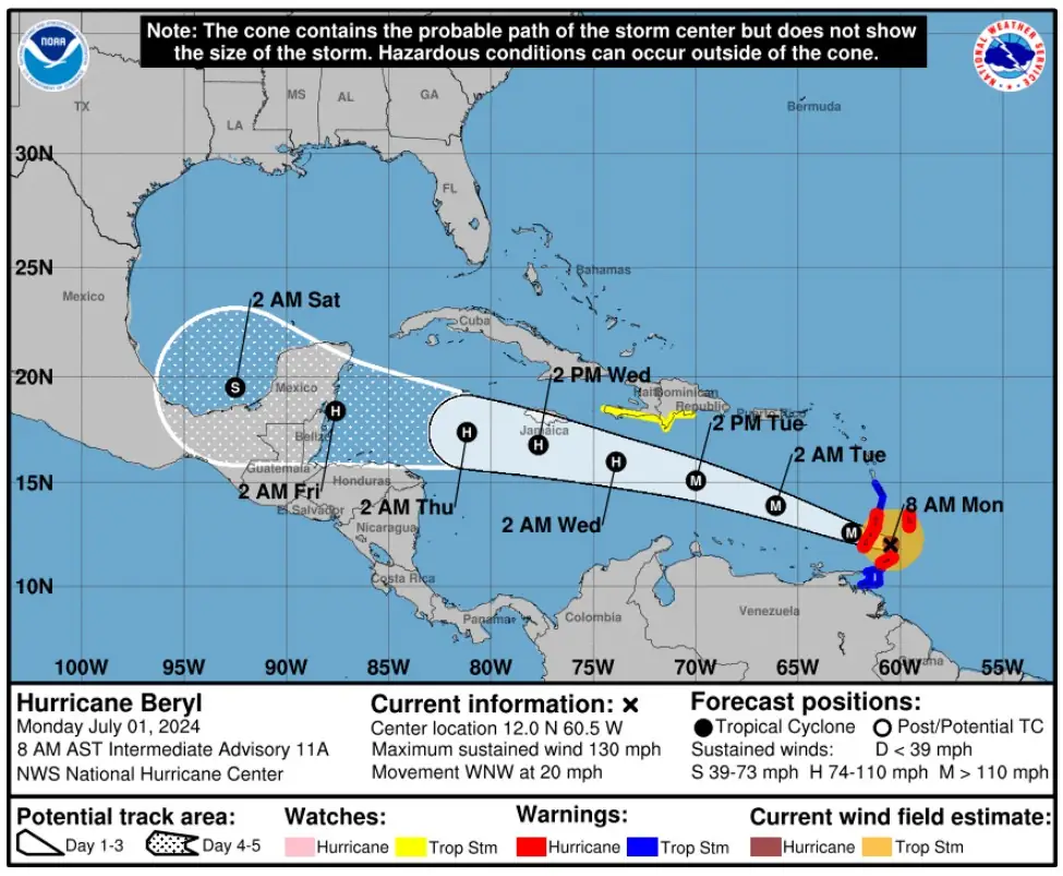
At 14:00 UTC on July 1, the center of Hurricane “Beryl” was located about 75 km (50 miles) E of Grenada and 40 km (25 miles) ESE of Carriacou Island, Grenada.
The system had maximum sustained winds of 215 km/h (130 mph) and a minimum central pressure of 956 hPa. It was moving WNW at 31 km/h (20 mph)

“Beryl is on track to be the strongest hurricane to hit the southernmost Windward Islands on record and the most intense for the area since Hurricane Ivan 20 years ago,” said Hurricane Specialist & Storm Surge Expert Michael Lowry.
“Potentially catastrophic winds, life-threatening storm surge, and flooding rains are forecast to sweep through parts of the easternmost Caribbean today that have never experienced a hurricane with such ferocity in records going back nearly 174 years.”
Beryl is the earliest Category 4 hurricane ever recorded in the Atlantic, eclipsing Hurricane “Dennis” which became a Category 4 hurricane on July 8, 2005, the first major hurricane in one of the most active and devastating hurricane seasons on record.
“Beryl intensified at a dizzying rate – 105 km/h (65 mph) in 24 hours – never observed so early in the hurricane season. Its rate of intensification is astonishing for any time of the hurricane season, with only 0.4% of 24-hour intensity changes in the satellite era (since 1966) as explosive as Beryl’s,” Lowry noted.
“The hurricane encountered a pristine upper-level environment while moving through record-warm Atlantic waters, waters as warm as they typically are in late August and September at the peak of the hurricane season.”
Updates
16:31 UTC, July 1
The extremely dangerous eyewall of Hurricane “Beryl” started moving over Carriacou Island around 15:00 UTC. At the time, Beryl had maximum sustained winds of 220 km/h (140 mph) and a minimum central pressure of 956 hPa.
“This is an extremely dangerous and life-threatening situation,” NHC said.
“Take action now to protect your life! Residents in Grenada, the Grenadine Islands, and Carriacou Island should not leave their shelter as winds will rapidly increase within the eyewall of Beryl. Remain in place through the passage of these life-threatening conditions and do not venture out in the eye of the storm.”
Beryl is expected to move quickly westward to west-northwestward during the next few days.
On the forecast track, the center of Beryl is currently moving across the southern Windward Islands and will move across the southeastern and central Caribbean Sea late today through Wednesday.
References:
1 Hurricane Beryl – Tropical Cyclone Update – NWS/NHC – 14:00 UTC on July 1, 2024
2 Unprecedented and Potentially Catastrophic Hurricane Beryl Closes in on the Eastern Caribbean – Eye on the Tropics – July 1, 2024
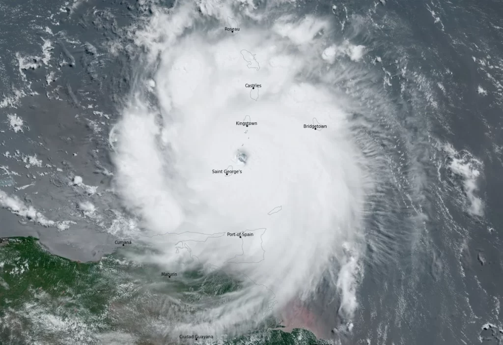
Featured image credit: Hurricane “Beryl” at 14:10 UTC on July 1, 2024. Credit: NOAA/GOES-East, RAMMB/CIRA, The Watchers
Commenting rules and guidelines
We value the thoughts and opinions of our readers and welcome healthy discussions on our website. In order to maintain a respectful and positive community, we ask that all commenters follow these rules.