
Rapid crustal uplift at Mt. Þorbjörn, Iceland
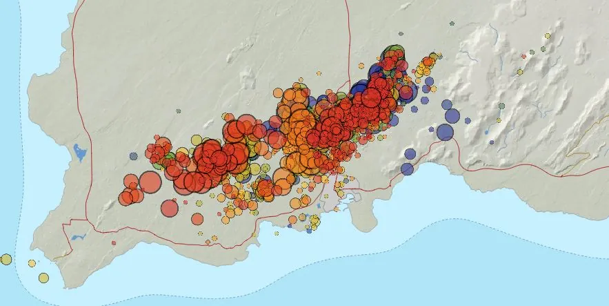
Image credit: IMO
The Icelandic Met Office (IMO) has reported a considerable upsurge in seismic activity on the Reykjanes Peninsula, with over 18 500 earthquakes recorded since the swarm began on October 25, just north of Grindavík.
- This region, known for its volcanic activity, has experienced a substantial increase in both the frequency and magnitude of seismic events, including five earthquakes exceeding magnitude 4 (M4), with the strongest being a M4.5.
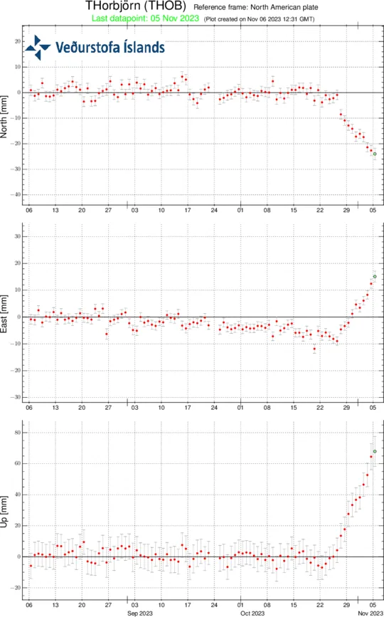
- Significant uplift of 7 cm (2.7 inches) has been registered in 10 days at GNSS station on Mt. Þorbjörn
- Recent models, based on data collected since October 27, have shown that the volume change associated with this inflation event is nearly double that of the cumulative changes observed during the four previous inflation events between 2020 and 2022.
The IMO’s latest findings indicate a notable uplift of 7 cm (2.7 inches) over a span of just 10 days at the GNSS station situated on Mt. Þorbjörn. In the preceding day alone, approximately 1 300 earthquakes were detected, three of which were above M3, including a M3.6 quake located 3 km (1.8 miles) northeast of Mt. Þorbjörn. This surge in seismic activity correlates with ongoing deformation in the region, pointing to a sustained inflation rate since November 3.
The uplift is caused by a sill-type intrusion at a depth of around 5 km (3.1 miles). Modeling, based on data since October 27, indicates that the volume change associated with this inflation event has reached almost two times the volume change associated with the four previous inflation events in the same area between 2020 – 22.
The inflow of magma/magmatic fluids into the sill-type body is estimated at approximately 7 m3/s — which is about four times greater than the highest inflow estimated during previous inflation events here.
The pattern of seismicity has shifted as well, with decreased activity north of Grindavík since November 2. However, the concentration of earthquakes has been mainly in the Sundhnjúkagígar area, northeast of Þorbjörn, and west of Eldvörp. While the frequency of quakes has reduced, the observed development in earthquake magnitudes and locations is in line with prior episodes linked to magma accumulation near Mt. Þorbjörn.
The ongoing uplift and seismic activity suggest that further stress-induced seismic events are likely to occur. The IMO cautions that rockfalls could follow larger earthquakes, especially near steep inclines, advising the public to exercise caution.
The IMO continues to monitor the situation with vigilance, in collaboration with the Civil Protection Agency, to promptly identify any signs of magma ascent towards the surface, which would manifest as increased, shallow seismicity, rapid surface deformation, and volcanic tremor. While no clear indications of imminent surface magma movement have been detected, the authorities remain alert to the possibility of rapid developments in the region’s volcanic activity.
References:
1 Uplift now 7 cm in 10 days at GNSS station on Mt. Þorbjörn – IMO – November 6, 2023
The Watchers team and our contributors bring the latest on extreme weather, earthquakes, volcanic eruptions, space weather, and all things science. We're all about making sense of the natural world and keeping you informed on what’s happening. Got a tip or a question? Hit us up using the form at newstips!
Commenting rules and guidelines
We value the thoughts and opinions of our readers and welcome healthy discussions on our website. In order to maintain a respectful and positive community, we ask that all commenters follow these rules.