
More than 4 700 earthquakes detected between Fagradalsfjall and Keilir in 48 hours, Iceland
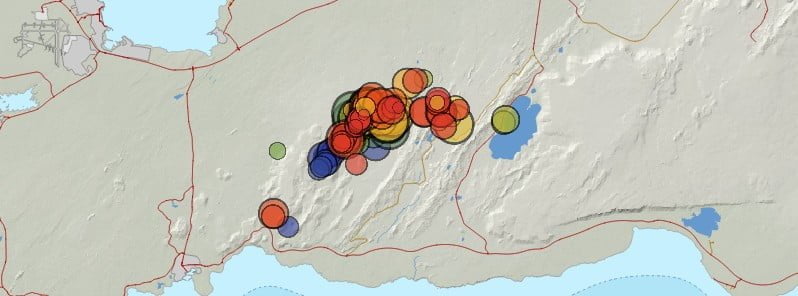
Image credit: IMO
More than 4 700 earthquakes have been detected in the area between Fagradalsfjall and Keilir, Reykjanes Peninsula, Iceland since the start of the seismic swarm at 14:00 UTC on July 4, 2023. Ground deformation (GPS) observations show significant movements, indicating magma propagation in the region where earthquakes are highly concentrated. Magma intrusion is close enough to the Earth’s surface that a volcanic eruption could occur without further escalations in seismic activity or ground deformation.
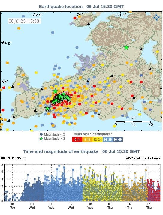
The current swarm is characteristic of a new dike intrusion beneath the Fagradalsfjall area, extending to the northeast towards Keilir. The largest earthquake was M4.8 at 8:21 UTC on July 5. Thirteen earthquakes above M4 have occurred and tens of earthquakes above M3. The largest earthquakes were felt widely in the SW part of Iceland.
Between 00:00 and 12:30 UTC on July 6, IMO detected 1 300 earthquakes, with the total number of earthquakes since July 4 exceeding 4 700.
Although the intensity of the swarm has decreased slightly, both in terms of the number of earthquakes and earthquake magnitudes, since 04:00 UTC on July 6, the Icelandic Met Office (IMO) specialists said care should be taken by steep slopes where rockfall can occur following strong earthquakes.
Residents in the vicinity of the area are encouraged to pay attention to loose and in-stock items.
The spatial distribution of earthquake epicenters is on the northeast-southwest lineament between Fagradalsfjall and Keilir, mostly concentrated just north of the mountain Litli Hrútur.
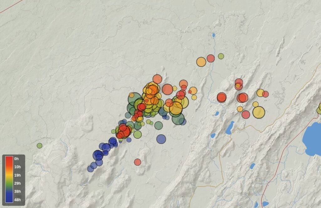
The latest ground deformation (GPS) observations show significant movements, indicating magma propagation in the region where earthquakes are highly concentrated.
The likely explanation is a northeast-southwest trending magma intrusion at 2 to 4 km (1.2 to 2.5 miles) depth. The intrusion is close enough to the Earth’s surface that a volcanic eruption could occur without further escalations in seismic activity or ground deformation.
Based on the present assessment, two outcomes are possible, IMO said.
The seismicity could decrease progressively without magma reaching the surface. Alternatively, the seismicity could still decrease when the magma stops moving laterally but begins to move upward towards the surface (as observed prior to the last 2 eruptions here). This would likely result in an eruption close to where seismicity is currently concentrated. However, magma reaching the surface anywhere in the region between Fagradalsfjall and Keilir cannot be excluded. Of the two possible outcomes, a volcanic eruption occurring within days or weeks is considered more likely.
While the earthquake swarm is ongoing, the main hazard is strong seismic ground motion due to the largest earthquakes in the sequence and potential triggered earthquakes on nearby faults. The largest earthquakes in the swarm have caused localized rockfalls, so people are advised against walking close to rock cliffs or steep slopes in the area around Keilir, Fagradalsfjall, and Kleifarvatn.
References:
1 Earthquake activity in Fagradalsfjall area – IMO – July 6, 2023
I'm a dedicated researcher, journalist, and editor at The Watchers. With over 20 years of experience in the media industry, I specialize in hard science news, focusing on extreme weather, seismic and volcanic activity, space weather, and astronomy, including near-Earth objects and planetary defense strategies. You can reach me at teo /at/ watchers.news.
Commenting rules and guidelines
We value the thoughts and opinions of our readers and welcome healthy discussions on our website. In order to maintain a respectful and positive community, we ask that all commenters follow these rules.