
Severe thunderstorms, derecho threaten the Gulf Coast as heat intensifies in Texas
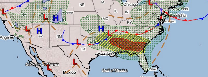
Image credit: NWS
Severe storms are predicted to persist along a lingering boundary, primarily affecting the Gulf Coast states and Southeast on June 14, 2023. The greatest threats are very large hail, damaging winds, and heavy rain with the potential for flooding. Texas, on the other hand, continues to experience building heat and humidity.
Much of the Deep South, particularly between the Lower Mississippi Valley and Southeast, is expected to encounter numerous strong-to-severe thunderstorms today. These storms, forming near a persistent stationary boundary, will move east-southeastward. The ingredients conducive for the development of these intense thunderstorms include significant atmospheric moisture from the Gulf of Mexico, robust westerly wind shear, and ample instability.
Storms are predicted to generate very large hail, damaging wind gusts, and even tornadoes. Notably, strong wind gusts pose the highest threat, especially across areas stretching from northeast Louisiana to southwest Georgia. In response to this, the Storm Prediction Center has issued a Moderate Risk (level 4/5) for severe weather across this region.
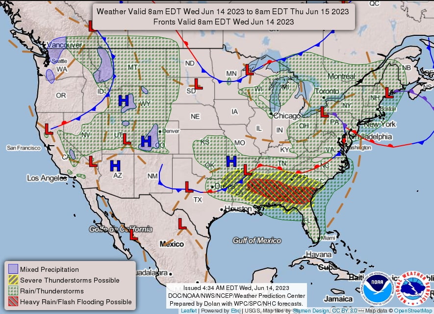
Furthermore, clusters of thunderstorms are likely to generate heavy rainfall. As storms overlap in similar areas, the risk of flash flooding increases, particularly in central Alabama to southern Georgia, with urban corridors and low-lying regions being most vulnerable.
TWC forecasters are warning there’s a possibility for a destructive derecho to develop near the Lower Mississippi Valley and track toward the central Gulf Coast this evening.
A derecho is a widespread, long-lived, straight-line wind storm that is associated with a fast-moving group of severe thunderstorms. These intense weather events can cause considerable damage over large areas and are capable of producing hurricane-like conditions and tornado-like damage, even though they are not related to tropical cyclones or tornadoes.
Derechos are characterized by a band of rapidly moving showers or thunderstorms variously known as a squall line, bow echo, or quasi-linear convective system. The term “derecho” was first used over a century ago, and it originates from the Spanish word for “straight” or “right,” reflecting the storm’s straight-line damaging winds, in contrast to the swirling winds of a tornado.
The powerful winds associated with derechos can exceed 162 km/h (100 mph), making them as potent as a Category 2 hurricane. They often form in the late spring and summer months when conditions for convection and thunderstorm formation are favorable. However, they can also occur at any time of the year when atmospheric conditions are right. The areas typically affected include the central and eastern United States, the Central Americas, as well as parts of Europe and Asia.
In a derecho, the damage path can extend hundreds of miles in length and over 80 km (50 miles) in width. The devastation can include downed trees, power lines, and even damage to buildings and homes. Following such storms, power outages are common and can last for days, affecting the everyday life of people in the impacted regions.
The active weather pattern is projected to continue into Thursday, June 13, across the Southeast and eastern Gulf Coast States, with increased chances for scattered severe thunderstorms and flash flooding. Residents and visitors in these areas are advised to have multiple means to receive weather warnings and to prepare a plan should severe weather conditions arise.
Meanwhile, Texas is bracing for increasing heat and humidity. The combination of soaring temperatures and high humidity levels is expected to pose significant challenges for residents in the coming days.
As always, individuals in affected areas should stay informed about the changing weather conditions and heed any advisories or warnings from local authorities and the National Weather Service.
References:
1 Short Range Forecast Discussion – NWS Weather Prediction Center College Park MD – 351 AM EDT Wed June 14, 2023
The Watchers team and our contributors bring the latest on extreme weather, earthquakes, volcanic eruptions, space weather, and all things science. We're all about making sense of the natural world and keeping you informed on what’s happening. Got a tip or a question? Hit us up using the form at newstips!
“The powerful winds associated with derechos can exceed 62 km/h (100 mph), making them as potent as a Category 2 hurricane. The……”
Hardly..! LOL.