
Parade of intense storms continues to batter California — rapid river rises, mudslides, and burn scar flash floods expected
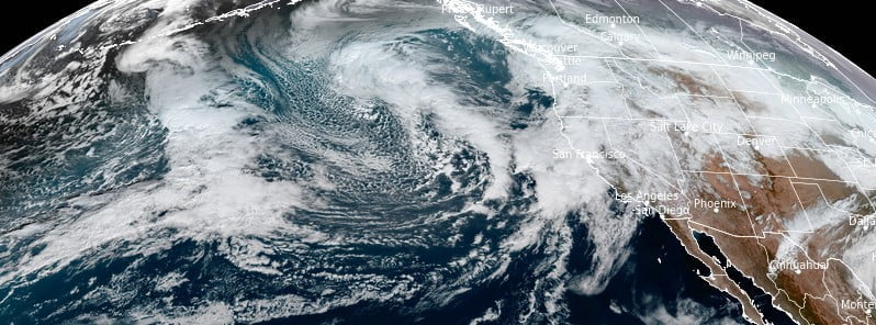
Image credit: NOAA/GOES-18, RAMMB/CIRA, The Watchers. Acquired at 20:10 UTC on January 7, 2023
The continuous rounds of heavy rain on already saturated soils across California will likely lead to significant flooding, rapid river rises, mudslides, and flash floods or debris flows in burn scar areas. In addition, gusty winds may cause trees and power lines to fall. Travel in the mountains may also be hazardous due to heavy snowfall.
- Northern and central California can expect more instances of heavy rain and mountain snow due to a relentless parade of atmospheric rivers
- An atmospheric river that could be the strongest in the past two days is expected to hit California beginning on Monday, January 9
Several rounds of anomalous atmospheric moisture content being flung into the West Coast will lead to additional hazardous weather conditions across central and northern California through at least the beginning of next week, NWS forecaster Snell noted.1
The current system bringing heavy rain and mountain snow is already impacting northern California and the San Francisco Bay area.
The heavy precipitation is expected to move south into central California tonight and bring heavy snow to the Sierra Nevada.
Previous heavy rainfall has already saturated the terrain, so additional heavy rain could lead to moderate river rises, flooding in poorly drained areas, and urban and roadway flooding.
An even stronger atmospheric river is expected to hit California on Monday, January 9, bringing several more inches of precipitation starting late Sunday night and lasting through Monday night.
The intensity and duration of the rain, combined with the accumulation of previous heavy rain events, will likely cause widespread and significant flooding.
Major river flooding and record-high river levels are possible.
A Moderate Risk (level 3/4) of Excessive Rainfall has been issued for Monday in central California, extending as far south as the Sierra Madre. Flood and Flash Flood Watches have also been issued.
“The impacts from this storm cannot be understated,” AccuWeather Meteorologist Joe Bauer said. “What sets this storm apart and could catapult it to extreme and historic levels is the preceding conditions,” AccuWeather experts said.2
The Sierra Nevada can expect reduced visibility, dangerous travel, and potential road closures due to additional heavy snow.
The threat of avalanches and infrastructure impacts will also increase with the added snow load.
Gusty winds may cause downed trees and power outages. Residents and visitors should check their local forecasts, avoid driving on flooded roads, and have emergency kits and evacuation plans in place.
According to AccuWeather forecasters, the recent stormy weather in California over the past two weeks, fueled by a consistent flow of moisture from the Pacific Ocean, has left a lasting impact and more is expected in the coming days and weeks.3
Over the 10-day period ending on January 4, Downtown San Francisco recorded 262.4 mm (10.33 inches) of rain, marking the wettest 10-day stretch there since January 1862 during the Civil War, when 365 mm (14.37 inches) fell between January 8 and 17. Records in San Francisco date back to 1849.
Major airports in the Bay Area have also received significantly more rainfall than average. From December 26, 2022, San Francisco International Airport recorded 224.5 mm (8.84 inches) of rain, which is 614% of the normal amount (36.6 mm / 1.44 inches) for this period.
Oakland International Airport measured 264.9 mm (10.43 inches) of rain over the same time frame, representing 767% of the normal amount — 34.5 mm (1.36 inches).
Since the beginning of California’s water season on October 1, a total of 399 mm (15.17 inches) of rain has fallen in Downtown San Francisco. On average, about 228.6 mm (9 inches) of rain is expected to fall between October 1 and January 5. Interestingly, more rain fell during the same period in 2021-2022 (425.7 mm or 16.76 inches), but this season is notable for a large amount of rain that fell over a shorter period of time — less than 14 days.
The recent storms have brought an exceptional amount of snow to the Sierra Nevada mountain range. The snowpack in the range is above average for the season thus far and in some places is approaching the average amount for a full winter season.
The California Department of Water Resources reports that the amount of water locked in the snow across the mountain range ranges from 381 mm (15 inches) to 508 mm (20 inches). In the southern Sierra Nevada range, that is currently around 200% of the normal amount for the season to date and is at 80% of the typical amount for an entire season.
The central and northern ranges are below the southern mountains, but they are still above average in the 140 – 185% range for the season thus far, which is 50-75% of the normal amount for a full season.
According to AccuWeather Lead Long-Range Forecaster Paul Pastelok, the weakening La Niña influenced the weather pattern over the Pacific, resulting in the current series of storms.
Pastelok stated, ‘A strong trail of storms across southern Asia moved across the Pacific from late December into early January and forced the subtropical jet stream farther south into California.’
The subtropical jet stream, which carries moisture-packed storms, usually stays north of California during the winter months in a La Niña year, but as Pastelok explains, a weakening La Niña can push that jet stream farther south into California.
References:
1 Short Range Forecast Discussion NWS Weather Prediction Center College Park MD 259 PM EST Sat Jan 07 2023
2 Dangers to life, property remain high in California as storm onslaught continues – AccuWeather – January 7, 2023
3 Relentless storm train resulting in eye-popping rain, snow totals in California – AccuWeather – January 6/7, 2023
I'm a dedicated researcher, journalist, and editor at The Watchers. With over 20 years of experience in the media industry, I specialize in hard science news, focusing on extreme weather, seismic and volcanic activity, space weather, and astronomy, including near-Earth objects and planetary defense strategies. You can reach me at teo /at/ watchers.news.
Commenting rules and guidelines
We value the thoughts and opinions of our readers and welcome healthy discussions on our website. In order to maintain a respectful and positive community, we ask that all commenters follow these rules.