
Eruption begins at Mauna Loa volcano after 38 years of quiescence – Aviation Color Code raised to Red, Hawai’i
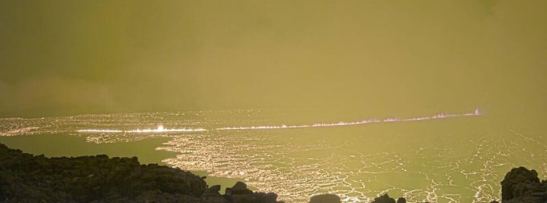
Image credit: HVO
A new eruption has begun at Mauna Loa — the largest active volcano on our planet — on November 28, 2022. As a result, the Aviation Color Code was raised to Red. The last eruption at this volcano took place in 1984 (VEI 0).
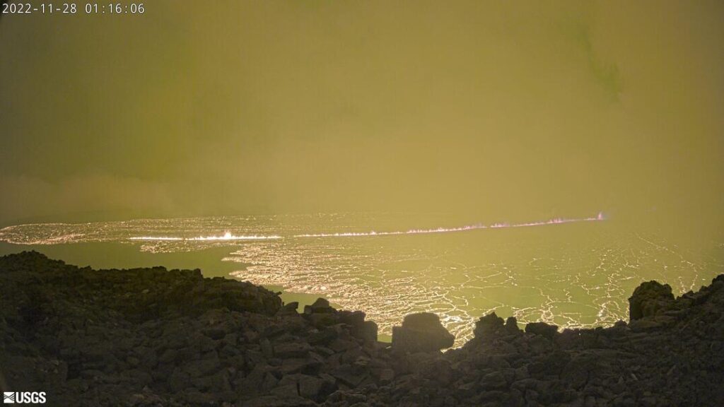
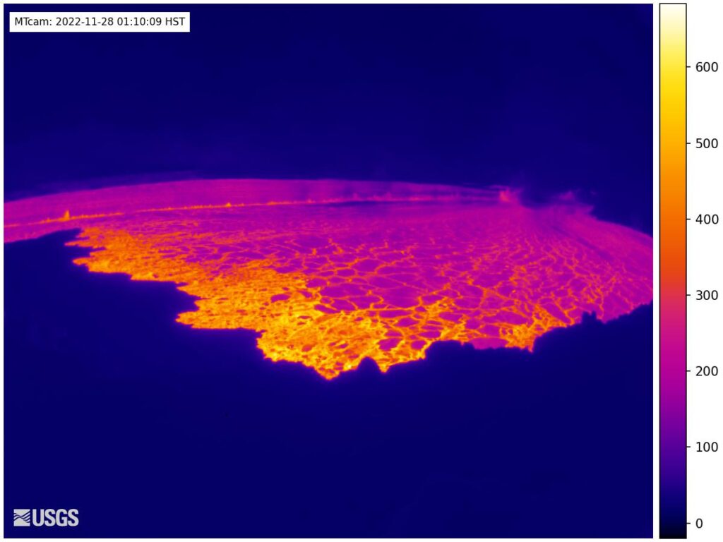
At approximately 09:30 UTC on November 28, 2022 (23:30 LT on November 27) an eruption began in Moku‘āweoweo, the summit caldera of Mauna Loa, inside Hawai‘i Volcanoes National Park, the Hawaiian Volcano Observatory (HVO) reports.1
At this time, lava flows are contained within the summit area and are not threatening downslope communities. Winds may carry volcanic gas and possibly fine ash and Pele’s hair downwind.
Residents at risk from Mauna Loa lava flows should review preparedness and refer to Hawai‘i County Civil Defense information for further guidance, HVO said.1
Based on past events, the early stages of a Mauna Loa eruption can be very dynamic and the location and advance of lava flows can change rapidly.
If the eruption remains in Moku‘āweoweo, lava flows will most likely be confined within the caldera walls. However, if the eruptive vents migrate outside its walls, lava flows may move rapidly downslope.
HVO is in close consultation with emergency management partners and will be monitoring the volcano closely to provide further updates on activity. As soon as possible, HVO will conduct aerial reconnaissance to better describe the eruption and assess hazards.
Strong volcanic ash emissions reaching 12.2 km (40 000 feet) above sea level were registered at 12:10 UTC.
At the time, volcanic ash clouds were extending approximately 185 km (115 miles) NE of the volcano, according to the Washington VAAC.
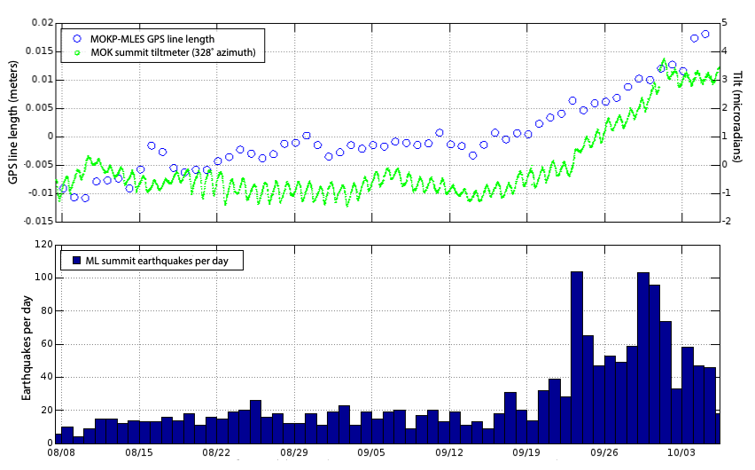
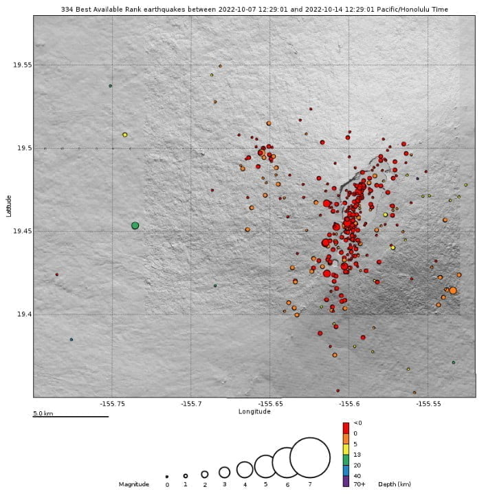
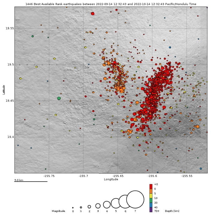
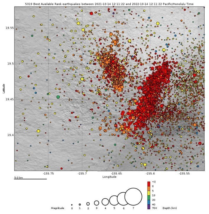
Heightened unrest under Mauna Loa began in mid-September 2022 with increased earthquake rates below its summit (from 10-20 per day to 40-50 per day), an increased rate of inflation recorded by GPS stations, and inflation recorded on the MOK tiltmeter.2
The last eruption at this volcano took place from March 25 to April 15, 1984 (VEI 0).
Updates
17:25 UTC, November 28
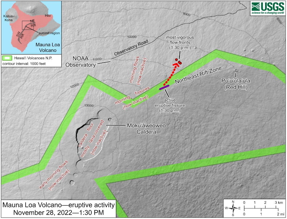
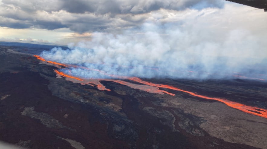
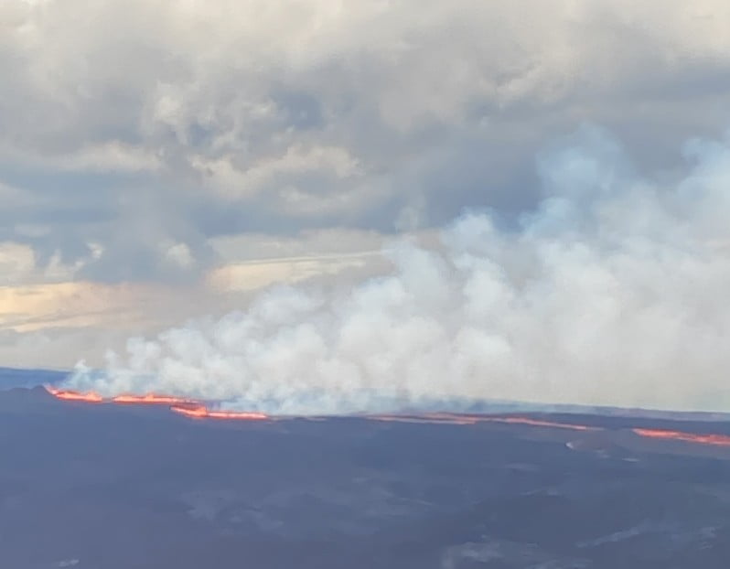
The eruption has migrated from the summit to the Northeast Rift Zone where fissures are feeding several lava flows.
HVO staff on an overflight at approximately 16:30 UTC confirmed fissures at high elevations within Hawai‘i Volcanoes National Park are feeding lava flows upslope of the Mauna Loa Weather Observatory.
Lava flows are not threatening any downslope communities and all indications are that the eruption will remain in the Northeast Rift Zone.
Volcanic gas and possibly fine ash and Pele’s Hair may be carried downwind.
Residents at risk from Mauna Loa lava flows should review preparedness and refer to Hawai‘i County Civil Defense information for further guidance.
09:02 UTC, November 29
Three fissures erupted as of 23:30 UTC on November 28, but only the lowest of the three fissures was active.
Estimates of the tallest fountain heights are between 30 and 60 m (100 – 200 feet), but most are a few meters tall, HVO volcanologists said.
The fissures sent lava flows to the northeast and parallel to the rift zone. Lava flows from the two higher fissures moved downslope but stalled about 18 km (11 miles) from Saddle Road.
Fissure 3 is currently feeding lava flows moving east parallel to the Northeast Rift Zone. These remain at an elevation above 3 km (10 000 feet) and more than 16 km (10 miles) away from Saddle Road.
“We do not expect upper fissures to reactivate. However, additional fissures could open along the Northeast Rift Zone below the current location, and lava flows can continue to travel downslope.
“There is no active lava within Moku’āweoweo caldera, and there is no lava erupting from the Southwest Rift Zone. We do not expect any eruptive activity outside the Northeast Rift Zone. No property is at risk currently. There is a visible gas plume from the erupting fissure fountains and lava flows, with the plume primarily being blown to the Northwest.”
Geological summary
Massive Mauna Loa shield volcano rises almost 9 km (5.6 miles) above the sea floor to form the world’s largest active volcano.
Flank eruptions are predominately from the lengthy NE and SW rift zones, and the summit is cut by the Mokuaweoweo caldera, which sits within an older and larger 6 x 8 km (3.7 x 5 miles) caldera.
Two of the youngest large debris avalanches documented in Hawaii traveled nearly 100 km from Mauna Loa; the second of the Alika avalanches was emplaced about 105 000 years ago (Moore et al. 1989).
Almost 90% of the surface of the basaltic shield volcano is covered by lavas less than 4 000 years old (Lockwood and Lipman, 1987).
During a 750-year eruptive period beginning about 1500 years ago, a series of voluminous overflows from a summit lava lake covered about one-fourth of the volcano’s surface.
The ensuing 750-year period, from shortly after the formation of the Mokuaweoweo caldera until the present, saw an additional quarter of the volcano covered with lava flows predominately from the summit and NW rift zone vents.
This volcano is located within the Hawaiian Islands, a UNESCO World Heritage property.3
References:
1 HVO/USGS Volcanic Activity Notice for Mauna Loa – HVO – November 28, 2022 at 09:45 UTC
2 Two moderate earthquakes near Mauna Loa volcano, string of aftershocks, Hawai’i – The Watchers – October 16, 2022
3 Mauna Loa – Geological summary – GVP
I'm a dedicated researcher, journalist, and editor at The Watchers. With over 20 years of experience in the media industry, I specialize in hard science news, focusing on extreme weather, seismic and volcanic activity, space weather, and astronomy, including near-Earth objects and planetary defense strategies. You can reach me at teo /at/ watchers.news.
Commenting rules and guidelines
We value the thoughts and opinions of our readers and welcome healthy discussions on our website. In order to maintain a respectful and positive community, we ask that all commenters follow these rules.