
Increased likelihood of eruption near Fagradalsfjall, Iceland
Featured image: Earthquake swarm in Reykjanes peninsula July 30 - 31, 2022. Credit: IMO, The Watchers
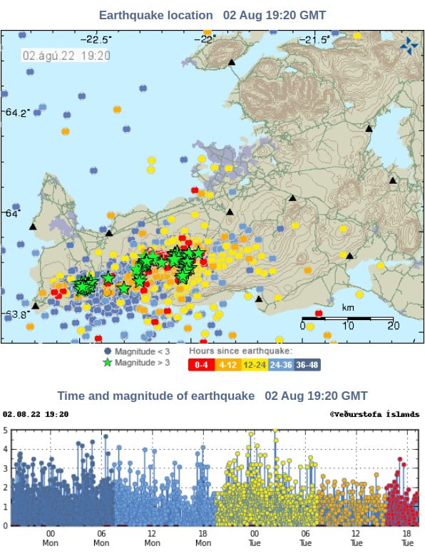
An intense earthquake swarm that started in the Krýsuvík-Trölladyngja volcanic system on July 30 continues and, according to the latest analysis by the Icelandic Meteorological Office (IMO), the chances of eruption in the area around Fagradalsfjall in the coming days or weeks have increased and are considered significant.
The results of the deformation models made today indicate that the magma tunnel under Fagradalsfjall lies very shallow or around 1 km (0.62 miles) below the surface.1
The magma influx is quite fast – close to double the rate of the previous eruption in February/March 2021.
While the deformation and seismic activity seem to be slowing down as of now but in the last year, it was one of the forerunners of the eruption.
The current insertion is along the northern side of the magma tunnel from last year and extends from the center of the tunnel halfway to Keilir. The chances of it erupting in the area around Fagradalsfjall in the coming days or weeks have therefore increased and are considered significant.
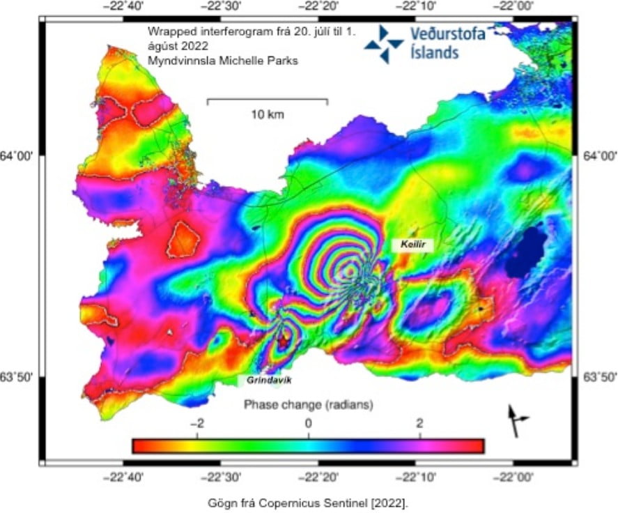
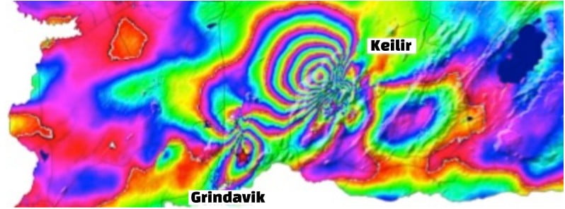
InSAR image made from Sentinel-1 satellite images clearly shows the magmatic intrusion between Keilir and Fagradalsfjall along with deformation parallel to the M5.47 earthquake that occurred at Grindavík on July 31, 2022.
Colored lines show deformation that is related to the magma intrusion at Fagradalsfjall that started around July 30, 2021.
The InSAR image shows 16 cm (6.3 inches) of displacement to the northwest associated with the intrusion.
The last eruption at this volcano started on March 19, 2021, after more than 50 000 earthquakes registered since February 24, and lasted until September 18, 2021 (VEI 0).
Here’s a selection of our articles covering it:
Geological summary
The Catalogue of Icelandic Volcanoes describes the Krýsuvík-Trölladyngja volcanic system as an approximately 50 km (31 miles) long composite fissure swarm trending about N38°E, including a 30 km (18 miles) long swarm of fissures, with no central volcano.
It is one of the volcanic systems arranged en-echelon along the Reykjanes Peninsula west of Kleifarvatn lake. The Fagradalsfjall and Krýsuvík fissure swarms are considered splits or secondary swarms of the Krýsuvík–Trölladyngja volcanic system.
Small shield volcanoes have produced a large portion of the erupted volume within the system. Several eruptions have taken place since the settlement of Iceland, including the eruption of a large basaltic lava flow from the Ogmundargigar crater row around the 12th century.2
References:
1 Jarðskjálftahrina á Reykjanesi – IMO – August 2, 2022
2 Krysuvik – Geological summary – GVP
I'm a dedicated researcher, journalist, and editor at The Watchers. With over 20 years of experience in the media industry, I specialize in hard science news, focusing on extreme weather, seismic and volcanic activity, space weather, and astronomy, including near-Earth objects and planetary defense strategies. You can reach me at teo /at/ watchers.news.
Commenting rules and guidelines
We value the thoughts and opinions of our readers and welcome healthy discussions on our website. In order to maintain a respectful and positive community, we ask that all commenters follow these rules.