
Intense Tropical Cyclone “Batsirai” to make landfall over Madagascar
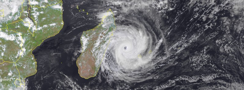
Featured image: Tropical Cyclone "Batsirai" at 11:00 UTC on February 4, 2022. Credit: EUMETSAT/Meteosat-11, RAMMB/CIRA, TW
Tropical Cyclone "Batsiari" continues intensifying on its way toward Madagascar. Landfall is expected on Saturday, February 5, between Mahanoro and Mananjary at a stage of Intense Tropical Cyclone, or even at the minimum state of Very Intense Tropical Cyclone.
Madagascar's national meteorological office has issued the following alerts:1
- Red Alert (Imminent danger) for ATSINANANA, VATOVAVY, FITOVINANY, ATSIMO ATSINANANA, MANGORO, ANALAMANGA, the districts of VAVATENINA, AMBATONDRAZAKA, ARIVONIMAMO, AMBATOLAMPY, ANTANIFOTSY, ANTSIRABE I-II, FANDRIANA, AMBOSITRA, MANANDRIANA, AMBOHIMAHASOA, LALANGINA, VOHIBATO, ISANDRA, FIANARANTSOA I, IVOHIBE and IAKORA.
- Yellow Alert (Threat) for BONGOLAVA, MENABE, ATSIMO ANDREFANA, ANOSY, ANDROY, the districts of STE MARIE, SOANIERANA IVONGO, FENERIVE-EST, AMPARAFARAVOLA, ANTSALOVA, MIARINARIVO, SOAVINANDRIANA, FARATSIHO, BETAFO, MANDOTO, AMBATOFINANDRAHANA, IKALAMAVONY and IHOSY.
- Green Alert (Warning) for the Districts of ANTALAHA, MAROANTSETRA, MANANARA AVARATRA, MANDRITSARA, ANDILAMENA, TSARATANANA and MAEVATANANA.
At 12:00 UTC on February 4, the center of Intense Tropical Cyclone "Batsirai" was located approximately 191 km (119 miles) NW of Saint-Denis, Réunion.
Its maximum 10-minute sustained winds were 185 km/h (115 mph), with gusts up to 260 km/h (160 mph), while maximum 1-minute sustained winds were 215 km/h (130 mph).
The minimum central barometric pressure was 934 hPa and the system was moving W at 9.3 km/h (5.8 mph).
Batsirai is currently in a very favorable environment for intensification with a very good upper-level divergence and weak shears under the upper-level ridge. This will continue until landfall.
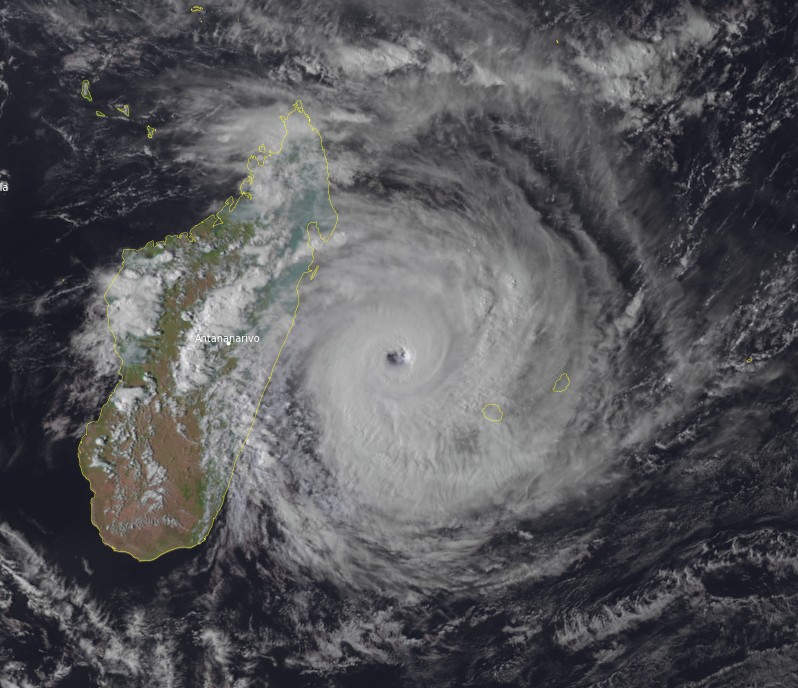
Tropical Cyclone "Batsirai" at 12:45 UTC on February 4, 2022. Credit: EUMETSAT/Meteosat-11, RAMMB/CIRA, TW
Madagascar is already feeling the impacts of rain and winds in regions located south of Vatomandry.
Up to 100 mm (3.9 inches) of rain, in general, is expected on the southern half, but with nuclei in the order of 300 to 400 mm (12 – 16 inches) on the littoral zones in the south of the landing zone, according to RSMC La Reunion.2
The cyclonic swell should reach the coast during Friday with heights close to 7 or 8 m (23 – 26 feet) in the most probable heights and maxima which can approach 15 m (50 feet).
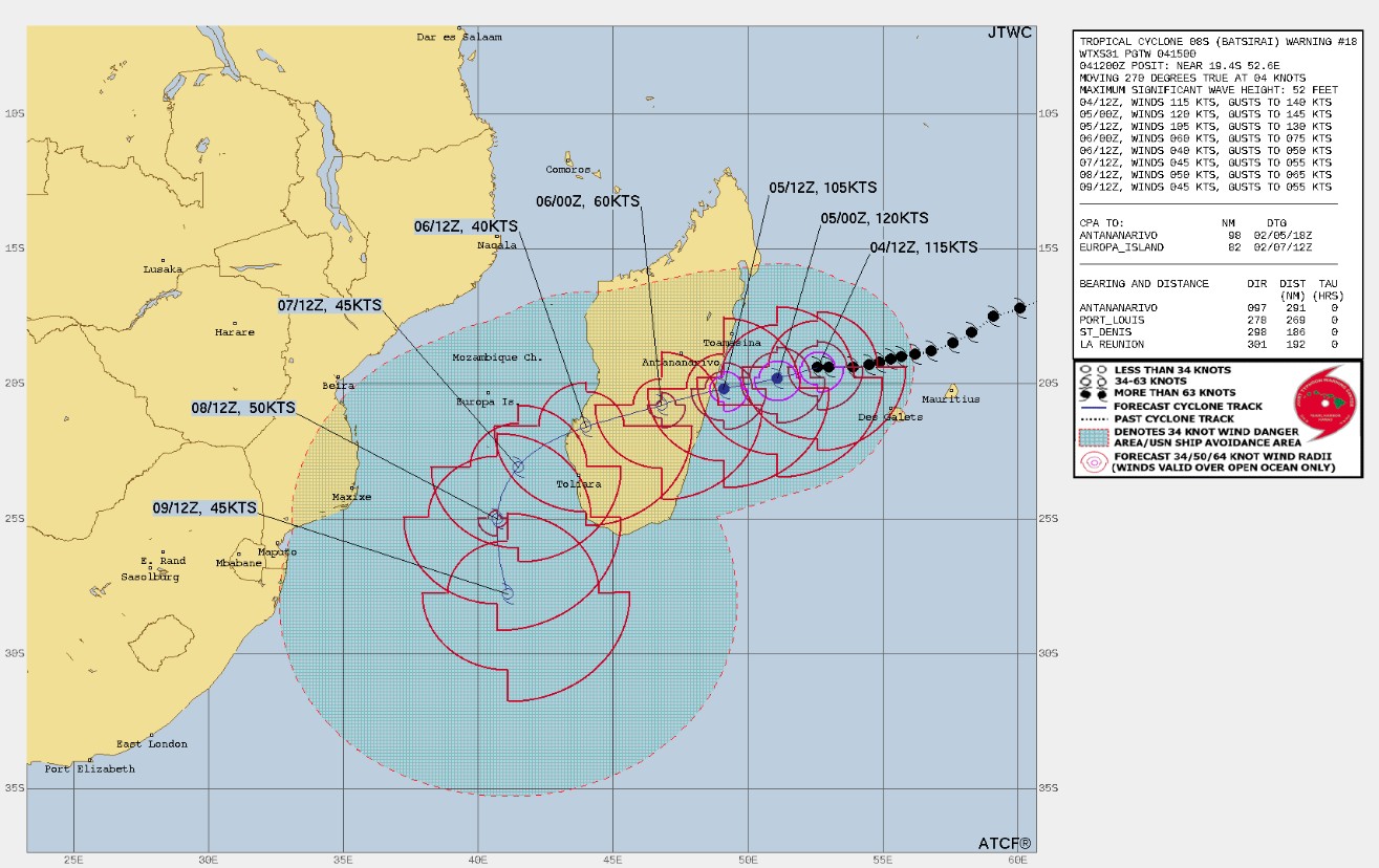
Landfall is expected on Saturday afternoon (LT) on the Malagasy coast, between Vatomandry and Mananjary with an uncertainty of about 100 km (62 miles) on the impact area.
A maximum surge of about 1 to 1.5 m (3 – 5 feet) or more is likely near and south of the landing zone.
The populations concerned are invited to follow the evolution of the cyclone with attention and to follow the instructions of the local authorities.
On Sunday, Batsirai will emerge into the southern Mozambique Channel, significantly weaker due to land interaction.
It will curve its trajectory southeast of Europa island, before curving its trajectory more towards the south at the beginning of next week because of the weakening and the shift towards the east of the subtropical ridge. The different guidelines seem to confirm this scenario which keeps the system away from Mozambique land.
In the Mozambique Channel, after a significant weakening following its passage over land, the system could again develop under fairly favorable conditions at least until Monday, benefiting from a good polar evacuation channel.
In the longer term, the environmental conditions (mainly shear, and the presence of dry air in the northwest of the system) should limit the intensity of the system as it plunges towards the southern latitudes.
Forecast models
References:
1 BULLETIN CYCLONIQUE SPECIAL ET PREVISION DE LA TRAJECTOIRE | 04 FEVRIER 2022 A 16 HEURES LOCALES – DGM Madagascar
2 RSMC / TROPICAL CYCLONE CENTER / LA REUNION – WARNING NUMBER: 38/2/20212022 – INTENSE TROPICAL CYCLONE 2 (BATSIRAI)
I'm a dedicated researcher, journalist, and editor at The Watchers. With over 20 years of experience in the media industry, I specialize in hard science news, focusing on extreme weather, seismic and volcanic activity, space weather, and astronomy, including near-Earth objects and planetary defense strategies. You can reach me at teo /at/ watchers.news.
Commenting rules and guidelines
We value the thoughts and opinions of our readers and welcome healthy discussions on our website. In order to maintain a respectful and positive community, we ask that all commenters follow these rules.