
Storm Barra to impact Ireland and UK with strong winds, heavy rain and snow
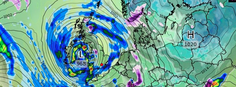
Image credit: wxcharts.com
A deep low-pressure area moving in from the Atlantic Ocean this week has been named Storm Barra by Met Éireann on Sunday, December 5, 2021, due to the level of impacts expected for the Republic of Ireland. After impacting Ireland, Barra will bring strong winds and rain to the United Kingdom, with the rain turning to snow across northern England and Scotland. Barra is the second named storm of the 2021/22 season, which runs from September 2021 through the end of August 2022.
As the system moves in from the west, the strongest winds and impacts are expected to affect the Republic of Ireland, according to the UK Met Office.1
Barra is expected to affect Ireland on Tuesday, December 7, and for a time on Wednesday, December 8. Multiple hazards will be associated with this system, Met Éireann said.2
Impacts will vary depending on location but will include:
- Storm force winds in places
- High seas and some coastal flooding
- Heavy squally falls of rain
- Some transient falls of sleet/snow possible, mainly in the northwest
- Some trees down
- Structural damage (Secure outdoor furniture and Christmas decorations!)
- Disruption to travel/hazardous driving conditions
An orange level wind warning has been issued for Counties Cork, Kerry, Limerick, Clare, and Galway valid from 06:00 LT on Tuesday to 06:00 LT on Wednesday, while a yellow level wind warning is in place for all other counties for the same time period.2
"These warnings are likely to be updated and fine-tuned as we come closer to the event as the track of the storm becomes more certain," Met Éireann meteorologists said.
"Winds will be south to southeast in direction during the early part of the Tuesday and will gradually veer westerly as the day goes on. So the strength of the wind will be dependent on your location and exposure to that particular direction.
"Some heavy falls of rain are likely too during Tuesday morning, these mainly across southern and southeastern counties with spot flooding possible."
As the system begins to weaken, it will bring strong winds and rain, with the rain turning to snow across northern England and Scotland, the office added.1
In response, the Met Office has issued a series of yellow National Severe Weather Warnings for wind and snow. These warnings will affect most of the UK.
"Strong winds arriving across the west through Tuesday morning, will spread inland and reach eastern areas through the afternoon and early evening," said Met Office's Chief Meteorologist, Frank Saunders.
"Gusts of 28 – 31 km/h (45 – 50 mph) are expected widely, with 37 – 44 km/h (60 – 70 mph) in exposed coastal locations. The strongest winds will ease across inland areas into the overnight period."
#StormBarra will give severe winds , heavy rain, high Seas and some coastal flooding.
For all latest warnings https://t.co/SATrWv2EIb pic.twitter.com/fIbALzawPT— Met Éireann (@MetEireann) December 5, 2021
#StormBarra has been named by @MetEireann and is forecast to bring strong winds to much of the UK and snow to northern areas on Tuesday and into Wednesday
Stay #WeatherAware pic.twitter.com/c6oMOwwa4m
— Met Office (@metoffice) December 5, 2021
Yellow weather warning issued
Snow across Scotland and northern England
Tuesday 1100 – 2359
Latest info https://t.co/QwDLMfRBfsStay #WeatherAware pic.twitter.com/Uou00iUWVf
— Met Office (@metoffice) December 5, 2021
Yellow weather warning issued
Strong winds across much of the UK
Tuesday 0900 – 2329Latest info https://t.co/QwDLMfRBfs
Stay #WeatherAware pic.twitter.com/E40xwQFpDI
— Met Office (@metoffice) December 5, 2021
"A band of rain will turn to snow across northern England and Scotland through Tuesday, December 7," UK Met Office's Deputy Chief Meteorologist, Brent Walker, said.
"2 – 5 cm (0.8 – 2 inches) of snow is expected to accumulate quite widely across the warning area, but locally this could reach 10 cm (4 inches), particularly in parts of the Southern Uplands and Highlands."
"Strong south-easterly winds will also lead to snow drifting in places, particularly over the highest routes, adding to poor visibilities."
References:
1 Storm Barra named – UK Met Office
2 Storm depression approaching Ireland Tuesday 7th December 2021 – Updated by Meteorologist Liz Walsh at 6 pm on Sunday 5th December 2021 – Met Éireann
I'm a dedicated researcher, journalist, and editor at The Watchers. With over 20 years of experience in the media industry, I specialize in hard science news, focusing on extreme weather, seismic and volcanic activity, space weather, and astronomy, including near-Earth objects and planetary defense strategies. You can reach me at teo /at/ watchers.news.
So some over-populated islands just off mainland Europe is likely to get a winter storm soon.
Err… like why is this important?
Just another so-so winter weather surely?
Nether unusual nor strange for the time of year, or is it just because there’s nearly 70 million people are living there, and the UK Met Orifice wish to big-up weather variability as their usual ‘climate crisis’ (non) event demands?
Ho-hum not so interesting.