
Intense earthquake swarm continues at Cumbre Vieja, deformation reaches 15 cm (5.9 inches) — La Palma, Canary Islands
Image credit: X-Y.es
An intense seismic swarm continues under Cumbre Vieja volcano, La Palma, the Canary Islands since 03:18 UTC on September 11, 2021, with more than 25 000 low-magnitude earthquakes detected to September 19. Of those, more than 1 450 were located, with the maximum magnitude 4.2 on the Richter scale on September 19.1 The Alert Level is still at Yellow for the municipalities of El Paso, Los Llanos de Aridane, Mazo, and Fuencaliente de la Palma.
Seismicity further increased over the past few hours, with intense surface seismicity between 0 and 6 km (0 – 3.7 miles) and numerous earthquakes felt by the population, IGN said in an update released 12:00 UTC today.
The accumulated maximum vertical deformation has increased to around 15 cm (5.9 inches) in the area close to the current seismicity and its distribution is still compatible with a center of pressure in this area. These movements have been observed both with the island's GNSS network and through InSAR data (Sentinel-1).
The following figure shows the hypocenters located in the last 24 hours (in red) and seismicity recorded since September 11 (in grey). The yellow star shows the hypocenters of the earthquake recorded this morning at 22:16 UTC with M4.2 at a very superficial depth.2
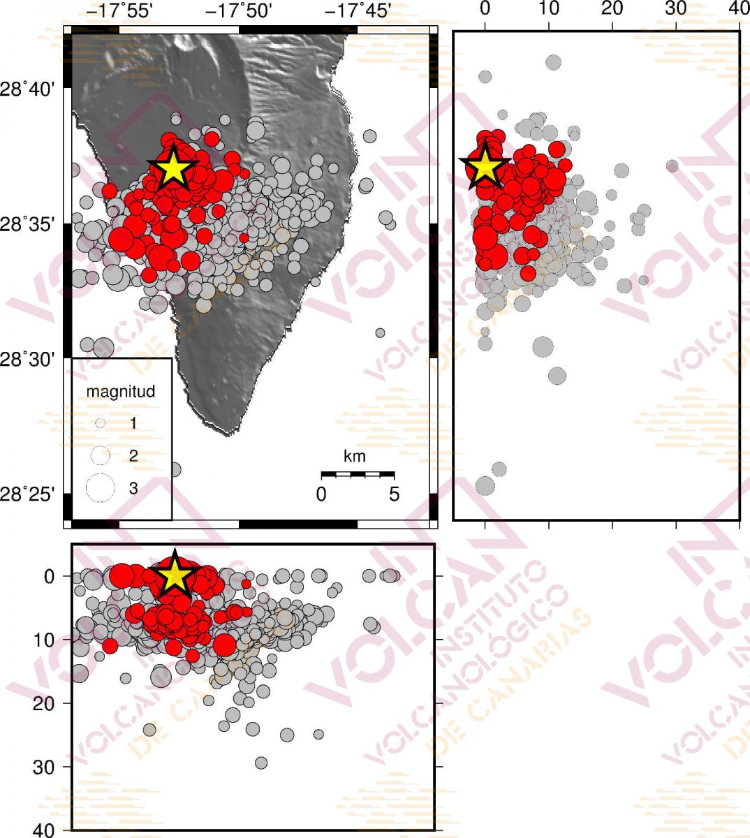
Image credit: INVOLCAN
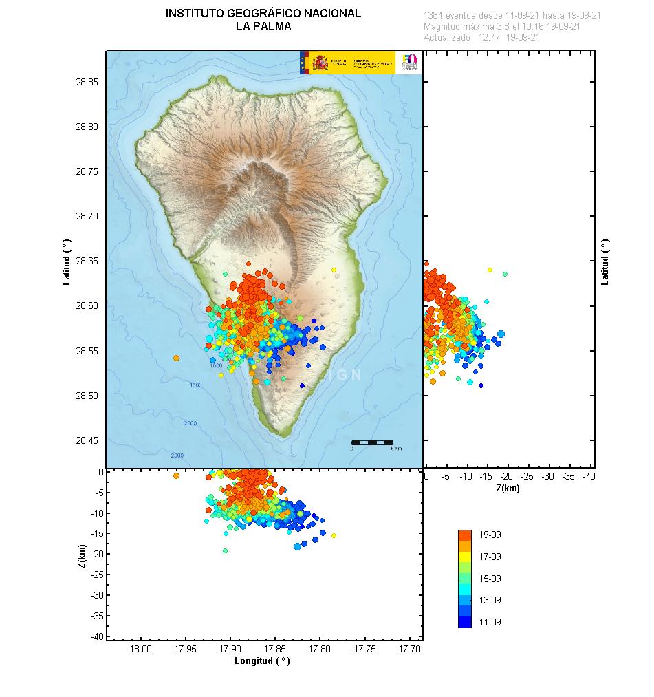
Image credit: IGN
There have been 10 seismic series with similar characteristics in this area of the island of La Palma since October 2017, but the current one is located at very shallow depths, suggesting magma is now reaching the surface.
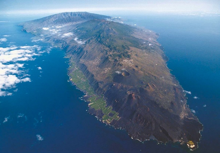
Image credit: INVOLCAN
"The recent volcanic reactivation in La Palma has once again sparked the debate on the stability of the west flank of the island, raising concerns in society," said Luis González de Vallejo, Director of the Geological Risks at INVOLCAN.3
Although the hypothesis of a possibility of a major collapse of the west side of the Cumbre Vieja and a megatsunami it could generate, has been rebutted and later discarded by numerous researchers, some media continue to talk about this catastrophic event, Vellejo added.
"For the Cumbre Vieja's flank to meet conditions close to instability, there would have to be an exceptionally high-magnitude earthquake coupled with large-magnitude volcanic eruption… or for the current volcano to grow at least another 1 000 m (3 280 feet). To reach this height, more than 40 000 years would have to go by, if we take the average growth rate of the island over the past 1 million years."
"The probability of an eruption with a high explosive rate at the same time as a large earthquake is extremely remote, according to the geological record of such events on the island. Therefore, the volcano is stable, and would remain stable even under the effects of eruptions similar to those that occurred over the last tens of thousands of years."
Una versión con la foto satélite enfocando más al Norte, e incluyendo el último evento, de magnitud 3.6 (era de 4 hace nada), a 2 km. de profundidad, a las 10.16. @VolcansCanarias pic.twitter.com/IuVo0LWug6
— X-Y.es (@x_y_es) September 19, 2021
Simulación en #3D de la evolución del enjambre sísmico en La Palma.
Realizada con @threejs con datos del @IGN_Sismologia.
Con la escala vertical corregida, y usando una fórmula cortesía de @JalMetra.@VolcansCanarias @IGNSpain #LaPalma #vigilanciaLaPalma pic.twitter.com/vTpSfKCj8D
— X-Y.es (@x_y_es) September 18, 2021
Geological summary
The 47-km-long (29 miles) wedge-shaped island of La Palma, the NW-most of the Canary Islands, is composed of two large volcanic centers. The older northern one is cut by the massive steep-walled Caldera Taburiente, one of several massive collapse scarps produced by edifice failure to the SW.
The younger Cumbre Vieja, the southern volcano, is one of the most active in the Canaries.
The elongated volcano dates back to about 125 000 years ago and is oriented N-S. Eruptions during the past 7 000 years have originated from the abundant cinder cones and craters along the axis of Cumbre Vieja, producing fissure-fed lava flows that descend steeply to the sea.
Historical eruptions at La Palma, recorded since the 15th century, have produced mild explosive activity and lava flows that damaged populated areas.
The southern tip of the island is mantled by a broad lava field produced during the 1677-1678 eruption. Lava flows also reached the sea in 1585, 1646, 1712, 1949, and 1971.4
References:
1 Information update on volcanic activity in the south of the island of La Palma. – 09-19-2021 12:00 UTC – IGN
2 INVOLCAN – FB
3 INVOLCAN – FB
4 La Palma – Geological summary – GVP
I'm a dedicated researcher, journalist, and editor at The Watchers. With over 20 years of experience in the media industry, I specialize in hard science news, focusing on extreme weather, seismic and volcanic activity, space weather, and astronomy, including near-Earth objects and planetary defense strategies. You can reach me at teo /at/ watchers.news.
Commenting rules and guidelines
We value the thoughts and opinions of our readers and welcome healthy discussions on our website. In order to maintain a respectful and positive community, we ask that all commenters follow these rules.