
Rare Red Warning for severe gales issued for South Island, New Zealand
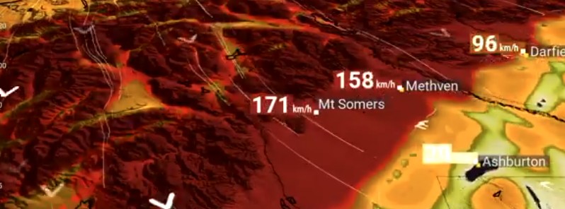
Image credit: NIWA
The New Zealand MetService has issued a rare Red Warning for severe gale northwesterly winds for the Canterbury High Country and foothills from Sunday afternoon (LT), September 12 into early Monday morning, September 13, 2021. The winds are expected to produce widespread damage, especially to trees and powerlines, and could lift roofs. Red Warnings are reserved for only the most extreme weather events where significant impact and disruption are expected.
These damaging winds are associated with a cold front as it moves northwards up the South Island today and early tomorrow.1
Northwesterly severe gales with gusts of 160 km/h (100 mph) are expected in exposed places, with the strongest winds expected later this evening into tomorrow morning (LT).
Although strong northwesterly winds are a common occurrence for the central South Island, wind gusts associated with this event are expected to be of a significant and damaging nature.
These winds are likely to result in widespread damage across the Canterbury High Country and foothills, especially to trees and power lines.
"Significant impacts are also expected to transport and power networks, with road closures and power outages likely," MetService expert meteorologist Hordur Thordarson said.
Driving conditions will be very hazardous, and there is a danger to life from falling trees or branches and flying debris. Impacts to properties include roofs being lifted and damage to unsecured structures.
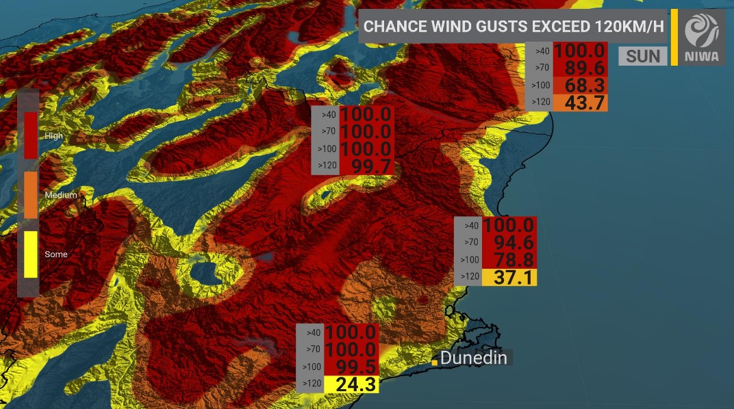
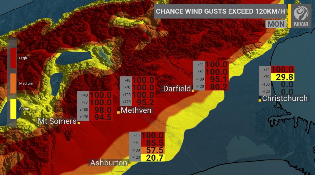
Image credit: NIWA
The remainder of the eastern South Island is currently under an Orange Warning, including the Canterbury Plains and Christchurch, which could also see damaging gales tonight into tomorrow morning.
The public is advised to keep up with the latest forecasts on www.metservice.com and to heed the advice of local Civil Defence and Emergency Management groups.
Here's another way to visualise the expected damaging wind gusts moving north with time.
Big red bars = damaging wind gusts.
Likely impacts:
-Power cuts
-Property damage
-Increased fire risk pic.twitter.com/fhdbnbpN9i— NIWA Weather (@NiwaWeather) September 12, 2021
Our friends at @MetService have issued a red warning for damaging wind gusts. Our high-resolution modelling echoes this expectation.
Please follow the advice of emergency officials. https://t.co/Q3Xv7MJ0ba pic.twitter.com/lMclFKFCmh
— NIWA Weather (@NiwaWeather) September 11, 2021
References:
1 MetService News Release 12/09/2021 – Covering period of Sunday 12 – Monday 13 September
I'm a dedicated researcher, journalist, and editor at The Watchers. With over 20 years of experience in the media industry, I specialize in hard science news, focusing on extreme weather, seismic and volcanic activity, space weather, and astronomy, including near-Earth objects and planetary defense strategies. You can reach me at teo /at/ watchers.news.
Commenting rules and guidelines
We value the thoughts and opinions of our readers and welcome healthy discussions on our website. In order to maintain a respectful and positive community, we ask that all commenters follow these rules.