
Aviation Color Code raised, uncertainty level declared for the ongoing uplift at Askja volcano, Iceland
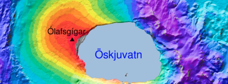
Image credit: IMO
The National commissioner in agreement with the Police Department of the North-East Iceland declared the uncertainty level because of the ongoing uplift at Askja volcano. In addition, the Aviation Color Code for the volcano was raised from Green to Yellow. This is done as the volcano is currently showing a level of activity beyond the known background.
In the last weeks, fast deformation changes have been measured in Askja, both from GPS stations and processed satellite images. The uplift has reached about 7 cm (2.7 inches) and that is a significant change over this temporal period, the Icelandic Met Office (IMO) reports.1
The most likely interpretation for this uplift is an inflow of magma at a depth between 2 – 3 km (1.2 – 1.8 miles).
In light of the latest data IMO has changed the Aviation Color Code for the volcano from Green to Yellow. This is done as the volcano is currently showing a level of activity beyond the known background.
For Civil Protection, the level of uncertainty means that there is the need for increased monitoring to follow those events that, eventually, might lead to a threat to the health and safety of people, the environment, and infrastructure.
Declaring a level of uncertainty is part of the Civil Protection planning procedures to ensure formal communication and exchange of information between different response parties, IMO said.
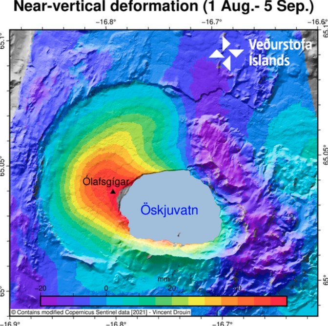
The image shows the near-vertical deformation in mm for the period August 1 to September 5, 2021. The InSAR image is obtained from two passages of Sentinel-1 satellite. Credit: IMO
GPS observations and ground deformation maps derived from Sentinel-1 satellite data reveal that the volcano began inflating at the beginning of August 2021.2
The uplift signal is centered on the western edge of Öskjuvatn, close to Ólafsgígar, and corresponds to ~5 cm/month (1.9 inches/month) of vertical motion.
Geodetic modeling (performed using both GPS and satellite data) indicates that the source of this inflation is located at a depth of approximately 3 km (1.8 miles) and corresponds to a volume change of approximately 0.001 km³/month.
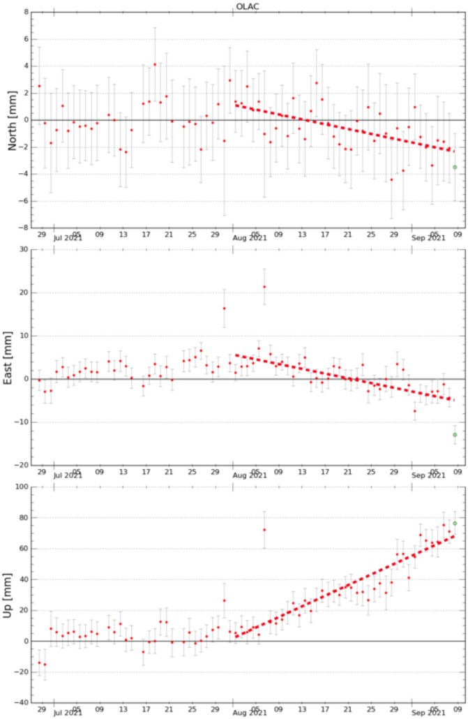
These graphs show GPS measurement from the station OLAC in the north, east, and up from July 27 – September 9, 2021. The station is close to the center of the uplift (shown in InSAR picture above) and it shows that in July/September the uplift started to show. Credit: IMO
Askja volcano is seismically active and earthquakes are regularly measured in the area.
The last eruption of this volcano took place in 1961 (VEI 2). Regular geodetic measurements were done in 1970 – 1972 and showed a period of uplift, however, no further measurements were acquired until 1983.
Since then, continued subsidence of a rate of 1 cm/year (0.4 inches/year) was detected until this current inflation phase started, IMO said.
Active volcanoes in Iceland are often characterized by periods of inactivity, lasting years to decades, with intervals of enhanced seismicity, geothermal activity, and inflation. In most cases, magmatic intrusions do not culminate into an eruption.
It is very difficult to anticipate how the situation will evolve at this state, IMO said.
Next week, IMO and the Institute of Earth Sciences (UÍ) will potentiate the monitoring network around Askja to allow a better coverage and surveillance of the volcano.
Geological summary
Askja is a large basaltic central volcano that forms the Dyngjufjöll massif. It is truncated by three overlapping calderas, the largest of which is 8 km (5 miles) wide and may have been produced primarily from subglacial ring-fracture eruptions rather than by subsidence.
A major rhyolitic explosive eruption from Dyngjufjöll about 10 000 years ago was in part associated with the formation of Askja caldera.
Many postglacial eruptions also occurred along the ring-fracture. A major explosive eruption on the SE caldera margin in 1875 was one of Iceland's largest during historical time. It resulted in the formation of a smaller 4.5-km-wide (2.8 miles) caldera, now filled by Öskjuvatn lake, that truncates the rim of the larger central caldera.
The 100-km-long (62 miles) Askja fissure swarm, which includes the Sveinagja graben, is also related to the Askja volcanic system, as are several small shield volcanoes such as Kollatadyngja. Twentieth-century eruptions have produced lava flows from vents located mostly near Öskjuvatn lake.
The renowned flat-topped Icelandic table mountain Herdubreid, located NE of Askja volcano, was active until the late Pleistocene.3
References:
1 Uncertainty level declared for the ongoing uplift at Askja volcano – IMO
2 Uplift signal detected in Askja volcano – IMO
3 Askja – Geological summary – GVP
I'm a dedicated researcher, journalist, and editor at The Watchers. With over 20 years of experience in the media industry, I specialize in hard science news, focusing on extreme weather, seismic and volcanic activity, space weather, and astronomy, including near-Earth objects and planetary defense strategies. You can reach me at teo /at/ watchers.news.
Commenting rules and guidelines
We value the thoughts and opinions of our readers and welcome healthy discussions on our website. In order to maintain a respectful and positive community, we ask that all commenters follow these rules.