
Scotland records coldest night in UK since 2010 as extreme cold snap continues
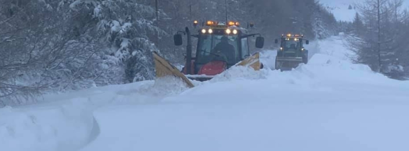
Image credit: Ramage Contractors
An extreme cold snap is ongoing in Scotland, which has brought record temperatures, heavy snowfall, and triggered severe weather warnings until Friday, February 12, 2021. On Tuesday, February 9, the coldest night in the UK since 2010 was recorded in the Scottish Highlands when the mercury dropped to -16.7 °C (1.9 °F).
As the cold snap continues, many transport services have been disrupted, with snow showers forecast to bring further travel disruptions in some areas. At the start of the week, there were reports of 10 to 15 cm (4 to 6 inches) in southeast coastal areas.
At Altanharra in the Scottish Highlands, the mercury plummeted to -16.7 °C (1.9 °F) on Tuesday, marking the UK's coldest night since December 2010, the Met Office confirmed.
Dubbed as the "Beast from the East 2", the cold snap brought more than 2 m (6 feet) of snow to the area, leaving farmers in distress as they had to plow over the snow. Ramage Contractors headed out in tractors to clear roads following some blizzards.
The latest satellite image shows extensive #snow cover across much of Scotland, northern and eastern England and a patchy cover in some other western areas
Have you got snow on the ground where you are?
The speckled clouds in the North Sea are snow showers pic.twitter.com/WWF4yx3lAj
— Met Office (@metoffice) February 10, 2021
On Wednesday morning, February 10, Stagecoach East Scotland canceled many of its early morning Fife services.
Rail services between Edinburgh and Glasgow were delayed due to the weather, while all Edinburgh tram services have been halted. More than 380 classes across the country were also canceled.
Authorities in Norfolk warned of blizzard-like conditions, adding that many roads have had snowdrifts and blockages.
According to Met Office spokesperson Nicola Maxey, "cold air crosses from Russia and eastern Europe, crosses the sea, picks up some moisture, then when it hits the land you see rain or because the air's so cold you see snow."
A yellow warning for snow and ice is in place for much of the country until Friday. The Met Office forecasts snow showers in the far northeast on Thursday, February 11, while it will be mostly dry and very cold on Friday.
Through the weekend, outbreaks of rain and snow will move slowly eastwards as the weather becomes less cold and increasingly windy.
Commenting rules and guidelines
We value the thoughts and opinions of our readers and welcome healthy discussions on our website. In order to maintain a respectful and positive community, we ask that all commenters follow these rules.