Powerful winter stom hits southern U.S., leaving more than 150 000 customers without power
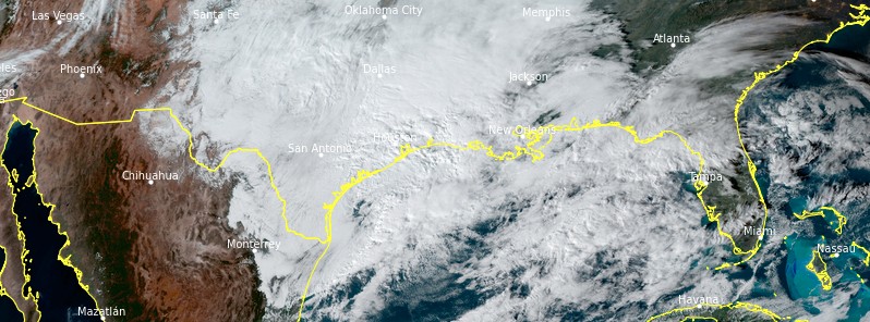
A powerful winter storm swept through Texas, Louisiana, and Mississippi on Sunday, January 10, 2021, leaving more than 150 000 customers without power.
Parts of Texas registered up to 23 cm (9 inches) of snow, causing power outages, making travel difficult, and forcing some schools and government offices to close.
Generally, around 10 to 15 cm (4 to 6 inches) fell across portions of Burleson, Brazos, Madison, and Houston counties, NWS said. A trace to 5 cm (2 inches) fell in portions Washington, Grimes, Walker, and Trinity counties. A wintry mixture of rain, sleet, and snow was reported as far south as the city of Houston.
Lubbock received 19.3 cm (7.60 inches) of snow yesterday, breaking old daily snowfall record of 11.4 cm (4.50 inches) set back in 1936. However, some parts places such as Denver City and Lamesa registered 22.8 cm (9 inches), Welch got 21.6 cm (8.5 inches) and Hobbs 20 cm (8 inches).
Looking for Snow? Turns out you could go to Texas to find it, they've gotten more snow with one storm than Pocatello has had all winter long thus far. #TexasSnow #idwx #txwx #WheresTheSnow pic.twitter.com/TcHN7L9KFH
— NWS Pocatello (@NWSPocatello) January 11, 2021
Good Monday morning!
Here are the final totals from this weekend's snow event! The forecast verified pretty well, with the highest accumulations occurring in Lubbock and points south. #TXwx #NMwx #KAMC #LubWX #PHwx #SPwx pic.twitter.com/0IIXbwRxXp
— Jacob Riley (@jrileywx) January 11, 2021
Here's a look at preliminary snowfall totals over the past 24 hours for South-Central Texas. Jarrell and Leander coming in as the biggest winners with 1/2 a foot of snow! We'll have a complete list of snowfall totals later this morning. #txwx #snow pic.twitter.com/Ym18UiI4XV
— NWS Austin/San Antonio (@NWSSanAntonio) January 11, 2021
The storm moved into Louisiana and Mississippi later on Sunday, dropping up to 10 cm (4 inches) of snow and prompting the Louisiana State Police to warn people to stay off the roads if possible.
State government offices in 29 Louisiana parishes will be closed Monday, January 11, including in Caddo Parish.
In Mississippi, more than a dozen school districts were closed, delayed, or scheduled for virtual learning on January 11.
At the height of the storm, more than 150 000 customers in Texas and Louisiana were without power. As of 12:00 UTC on January 11, 103 800 customers are still without power in Texas and 46 800 in Louisiana.
Accumulating snow will continue in the Lower Mississippi Valley into midday, NWS said. In addition, a plume of deep Pacific moisture will impact the Pacific Northwest into midweek, causing multiple rounds of heavy rain along the coast and in lower elevations and high elevation snow. The rain may result in flooding, especially in and around recent burn scar areas as debris flows and mudslides will be possible.
"The low pressure system currently gliding across the Gulf Coast will move across Florida and into the Atlantic late tomorrow," NWS forecaster Kebede noted at 06:39 UTC today.
Snow is likely to wind down across the Southeast today while rain and thunderstorms impact the coast through tonight.
Additional snow amounts are likely to remain below 2.5 cm (1 inch) in most places. Some light showers are possible along the Southeast coast tomorrow, January 12 as the system moves off into the Atlantic.
Winter Storm Advisories and Warnings remain in effect for parts of eastern Texas through the Lower Mississippi Valley.
Highs are expected to be much below average across Texas and the Lower Mississippi Valley today as the low pressure system pulls cool air down and high pressure expands over the area.
Temperatures may be down to 15 °C (25 °F) below average in some places today.
This cool air mass is likely to recede over the Southern Plains on Tuesday as the system moves off into the Atlantic.
Meanwhile, the Northern/Central Plains will see anomalously warm air infiltrate into the region through Tuesday with highs likely to be over 15 °C (25 °F) above average in some places.
Featured image credit: NOAA/GOES-East
Texas is getting more snow than the north central USA and we’re nearly a thousand miles north? Our ski hills are going out of business for lack of snow and COVID. The way the weather is going in the USA I expect to hear about snow storms in the Sahara desert rather than seeing a good snow storm in the north central USA.