
Laura forecast to rapidly strengthen into Category 4 hurricane before making landfall, U.S.
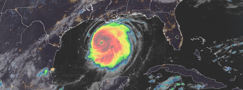
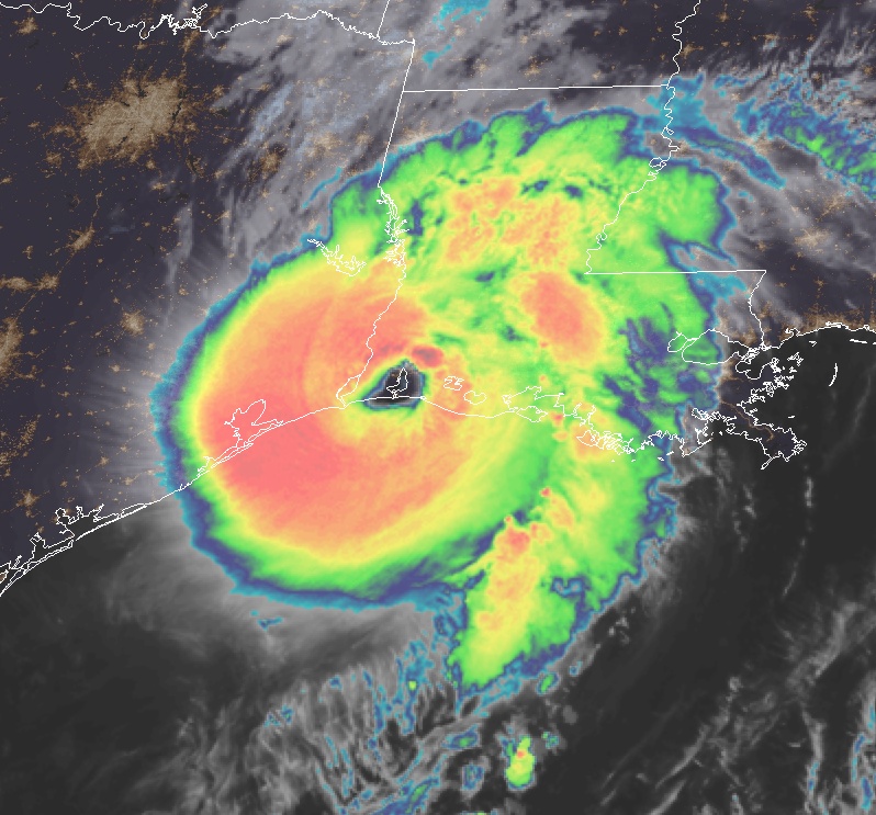
Featured image: Hurricane "Laura" at 11:00 UTC on August 26, 2020. Credit: NOAA/GOES-East, RAMMB/CIRA
Hurricane "Laura" is expected to rapidly strengthen to a Category 4 hurricane before it approaches Upper Texas and southwest Louisiana coasts and moves island near those areas tonight, August 26 or Thursday morning (LT), August 27, 2020.
Potentially catastrophic storm surge, extreme winds, and flash floods are expected along the northwest Gulf Coast tonight (LT).
At 12:00 UTC on August 26, Laura's center was located about 450 km (280 miles) SSE of Lake Charles, Louisiana, and 465 km (290 miles) SE of Galveston, Texas.
The storm had maximum sustained winds of 185 km/h (115 mph) and minimum central pressure of 963 hPa. This makes it a Category 3 hurricane on the Saffir-Simpson Hurricane Wind Scale.
It was moving NW at 24 km/h (15 mph) and this general motion should continue today, followed by NNW motion tonight (LT).
On the forecast track, Laura should approach Upper Texas and southwest Louisiana coasts this evening and move inland near those areas tonight or Thursday morning.
NHC forecasters expect the system to continue strengthening into a category 4 hurricane later today, followed by rapid weakening after landfall.
Key NHC messages:
Life-threatening storm surge with large and dangerous waves is expected to produce potentially catastrophic damage from San Luis Pass, Texas, to the Mouth of the Mississippi River, including areas inside the Port Arthur Hurricane Flood Protection system.
This surge could penetrate up to 50 km (30 miles) inland from the immediate coastline in southwestern Louisiana and southeastern Texas. Actions to protect life and property should be rushed to completion as water levels will begin to rise later today.
Hurricane-force winds are expected tonight in the warning area from San Luis Pass, Texas, to west of Morgan City, Louisiana, and the strongest winds associated with Laura's eyewall will occur somewhere within this area. Hurricane-force winds and widespread damaging wind gusts are also expected to spread well inland into portions of eastern Texas and western Louisiana early Thursday.
Widespread flash flooding along small streams, urban areas, and roadways is expected to begin this afternoon into Thursday from far eastern Texas, across Louisiana and Arkansas. This will also lead to minor to isolated moderate freshwater river flooding.
The heavy rainfall threat and localized flash and urban flooding potential will spread northeastward into the middle-Mississippi, lower Ohio and Tennessee Valleys Friday night and Saturday.
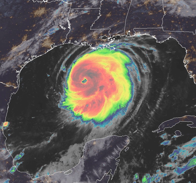
Hurricane "Laura" at 22:40 UTC on August 25, 2020. Credit: NOAA/GOES-East, RAMMB/CIRA
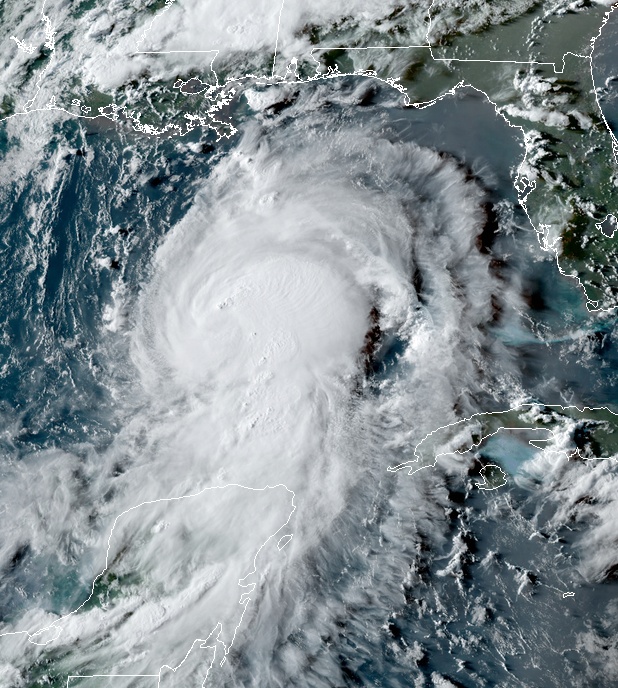
Hurricane "Laura" at 11:00 UTC on August 25, 2020. Credit: NOAA/GOES-East, RAMMB/CIRA
The hurricane has intensified a remarkable 75 km/h (45 mph) during the past 24 hours, and there are no signs it will stop soon, with shear remaining low-to-moderate over the deep warm waters of the central Gulf of Mexico, NHC forecaster Blake noted at 09:00 UTC.
"Increasing shear is expected to slightly weaken the hurricane close to landfall, so the new forecast keeps the previous 195 km/h (120 mph) intensity near the coast.
Laura will weaken rapidly after landfall, but it will likely bring hurricane-force winds well inland over western Louisiana and eastern Texas. In the extended range, there is some chance that Laura re-intensifies as a tropical cyclone off the Mid-Atlantic coast, instead of becoming part of a frontal system, but for now the forecast will stay extratropical at 96 hours and beyond."
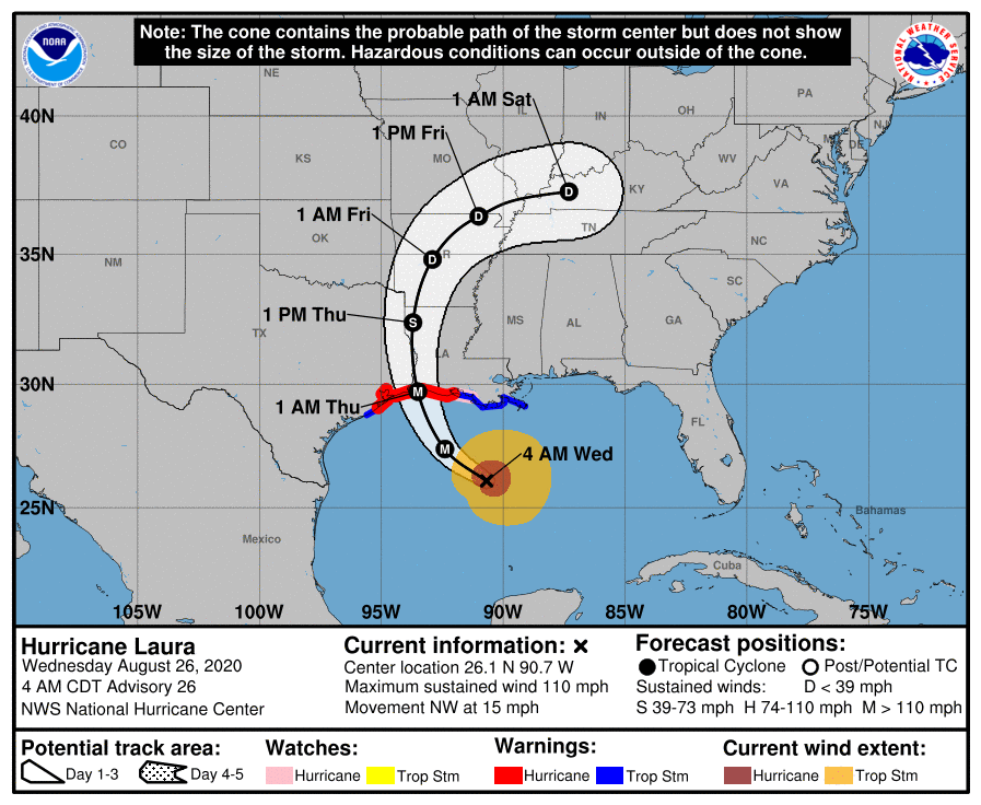
"It should be mentioned Laura is now a large hurricane, and wind, storm surge, and rainfall hazards will extend far from the center. Do not use the cone graphic for any representation of these hazards, it is just for the center uncertainty," Blake said.
At 12:00 UTC on August 26 a Storm Surge Warning is in effect for:
– Freeport Texas to the Mouth of the Mississippi River.
A Hurricane Warning is in effect for:
– San Luis Pass Texas to Intracoastal City Louisiana.
A Tropical Storm Warning is in effect for:
– Sargent Texas to San Luis Pass.
– East of Intracoastal City Louisiana to the Mouth of the Mississippi River.
A Storm Surge Watch is in effect for:
– Mouth of the Mississippi River to Ocean Springs Mississippi.
– Lake Pontchartrain, Lake Maurepas, and Lake Borgne.
A Hurricane Watch is in effect for:
– East of Intracoastal City to west of Morgan City Louisiana.
Storm surge and tropical-storm-force winds will arrive within the warning areas well in advance of Laura's center later today. All preparations to protect life and property should be rushed to completion in the next few hours, NHC warns.
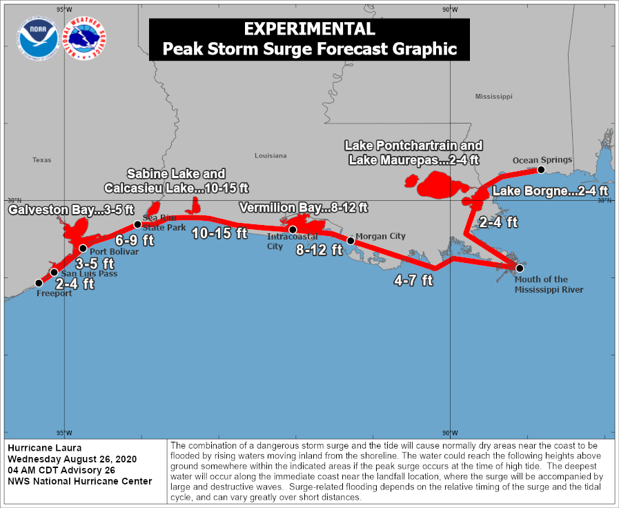
The combination of a dangerous storm surge and the tide will cause normally dry areas near the coast to be flooded by rising waters moving inland from the shoreline.
The water could reach the following heights above ground somewhere in the indicated areas if the peak surge occurs at the time of high tide.
- Sea Rim State Park to Intracoastal City including Sabine Lake and Calcasieu Lake: 3 – 4.5 m (10 – 15 feet).
- Intracoastal City to Morgan City including Vermilion Bay: 2.4 – 3.6 m (8 – 12 feet).
- Port Bolivar to Sea Rim State Park: 1.8 – 2.7 m (6 – 9 feet).
- Morgan City to Mouth of the Mississippi River: 1.2 – 2.1 m (4 – 7 feet).
- San Luis Pass to Port Bolivar: 0.9 – 1.5 m (3 – 5 feet).
- Galveston Bay: 0.9 – 1.5 m (3 – 5 feet).
- Mouth of the Mississippi River to Ocean Springs including Lake Borgne: 0.6 – 1.2 m (2 – 4 feet).
- Lake Pontchartrain and Lake Maurepas: 0.6 – 1.2 m (2 – 4 feet).
- Freeport to San Luis Pass: 0.6 – 1.2 m (2 – 4 feet).
The deepest water will occur along the immediate coast near and to the right of the landfall location, where the surge will be accompanied by large and destructive waves. This storm surge could penetrate up to 50 km (30 miles) inland from the immediate coastline in southwestern Louisiana and far southeastern Texas. Surge-related flooding depends on the relative timing of the surge and the tidal cycle, and can vary greatly over short distances. For information specific to your area, please see products issued by your local National Weather Service forecast office.
Hurricane conditions are expected in the hurricane warning area tonight and Thursday, August 27. Tropical storm conditions are expected to reach the coast in the hurricane warning area late today or tonight, and are expected in the tropical storm warning area tonight and Thursday. Hurricane-force winds and damaging wind gusts are also expected to spread well inland into portions of eastern Texas and western Louisiana early Thursday (LT).
From this afternoon through Friday, Laura is expected to produce rainfall totals of 125 – 250 mm (5 to 10 inches), with isolated maximum amounts of 380 mm (15 inches) across portions of the northwestern Gulf Coast from western Louisiana to far eastern Texas, and northward into much of Arkansas.
Over the lower to middle Mississippi Valley from central Louisiana into western Tennessee and Kentucky and southeastern Missouri, 50 – 100 mm (2 to 4 inches) of rainfall with isolated totals of 150 mm (6 inches) are expected.
This rainfall will cause widespread flash and urban flooding, small streams to overflow their banks, and minor to isolated moderate river flooding.
By late Friday into Saturday, portions of the Tennessee and Ohio Valley could see 50 – 100 mm (2 to 4 inches) with locally higher amounts as tropical moisture from Laura moves through the region. This rainfall could lead to localized flash and urban flooding along small streams.
A few tornadoes are expected this evening through tonight over Louisiana, far southeast Texas, and southwestern Mississippi. The risk for a few tornadoes should continue into Thursday across Louisiana, Arkansas, and western Mississippi.
Swells produced by Laura are affecting the U.S. Gulf coast from the west coast of Florida to Louisiana and are expected to reach the coast of Texas and northeastern Mexico today. These swells are likely to cause life-threatening surf and rip current conditions.
Laura is the first major hurricane in the Gulf of Mexico since Michael in 2018 and the first major hurricane in the Gulf of Mexico during the month of August since Harvey in 2017, Dr. Philip Klotzbach notes.
"When Laura makes landfall in about 24 hours, it will be the record 7th named storm to hit the continental US (CONUS) before the end of August. The current record for CONUS named storm landfalls by the end of August is 6, set in 1886, 1916, and 2020."
The average date of the first major hurricane in the Atlantic Ocean is September 4.
9 major hurricanes on record (since 1851) have tracked within 80 km (50 miles) of Laura's current location. The most recent of these is Hurricane "Rita" in 2005.
Update, 07:55 UTC, August 27
Category 4 Hurricane "Laura" made landfall near Cameron in southwestern Louisiana at 06:00 UTC (01:00 CDT) with maximum sustained winds of 241 km/h (150 mph) and minimum central pressure of 938 hPa.
"Catastrophic storm surge, extreme winds, and flash flooding occurring in portions of Louisiana," NWS forecasters said.
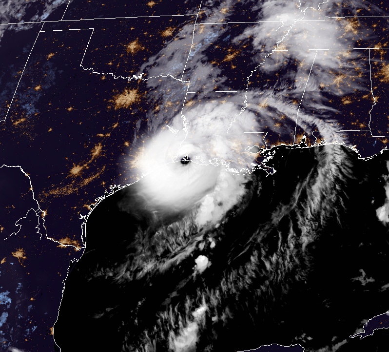
Hurricane "Laura" at 05:40 UTC on August 27, 2020. Credit: NOAA/GOES-East, RAMMB/CIRA
Hurricane "Laura" at 06:00 UTC on August 27, 2020. Credit: NOAA/GOES-East, RAMMB/CIRA
Multimedia
I'm a dedicated researcher, journalist, and editor at The Watchers. With over 20 years of experience in the media industry, I specialize in hard science news, focusing on extreme weather, seismic and volcanic activity, space weather, and astronomy, including near-Earth objects and planetary defense strategies. You can reach me at teo /at/ watchers.news.
Commenting rules and guidelines
We value the thoughts and opinions of our readers and welcome healthy discussions on our website. In order to maintain a respectful and positive community, we ask that all commenters follow these rules.