
‘Once-in-500-years’ storm hits Northland, cutting off Far North from the rest of the country, New Zealand
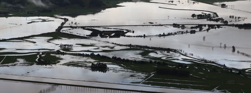
Featured image: Widespread flooding in Whangarei on July 18, 2020. Credit: Whangarei Flying Club
Unusual interaction between two low-pressure zones caused intense storms over New Zealand's Northland on July 17, 2020. The worst affected was Whangarei, where emergency services responded to more than 220 calls. "This is just diabolical for our people. We've gone from drought to dealing with a 1 in 500-year event. Unbelievable," Whangārei Mayor Sheryl Mai said.
According to MetService meteorologists, the storm dropped 220 mm (8.6 inches) of rain on Whangarei from 19:00 LT on July 17 to 07:00 LT on July 18. 'We call this a greater-than-500-year return period,' the service said.
The worst of the storm came around 19:00 LT, with about 50 mm (1.9 inches) per hour.
Several gauges exceeded 250 mm (9.8 inches) of rain in 24 hours, including over 150 mm (5.9 inches) in just 4 hours at Whangarei Aero and 56.8 mm (2.2 inches) at Kaikohe in just 1 hour.
According to NIWA, Whangarei recorded its wettest July hour on record between 20:00 and 21:00 LT on July 17, with 39.6 mm (1.5 inches).
132.6 mm (5.2 inches) fell in just 4 hours between 18:00 and 22:00 LT, which is 78% of the monthly normal.
Further rainfalls of 40 to 60 mm (1.5 – 2.3 inches) an hour could still fall this morning, July 18, MetService said, adding that the storm should break by the afternoon and turn to periods of showers later in the day before petering off tomorrow.
Officials are urging residents to stay off the roads and to keep up with weather watches and warnings via MetService.
Old, slow moving low to the northwest. In the South: ridge trapping low cloud in valleys. Between: easterlies, troughs and a weak front. Get the details for your location at https://t.co/hnwmGxU1gR ^RK pic.twitter.com/hl4cNd5XHG
— MetService (@MetService) July 18, 2020
Whangārei recorded its wettest July hour on record between 8-9 pm Friday, with 39.6 mm
132.6 mm fell in just 4 hours between 6-10 pm or 78% of the monthly normal!
Moderate to heavy rain is expected to continue. Remember to never cross flooded roadways! pic.twitter.com/k43M3UpQZd
— NIWA Weather (@NiwaWeather) July 17, 2020
Why the wild weather? The low has nowhere to go! This weekend's weather will be a "rinse and repeat" of today as the low continues to direct a cloudy, northeast flow across the north, and a ridge maintains settled weather to the south. Details at https://t.co/Yjbq0jxdqz ^Tahlia pic.twitter.com/BGmOraz7wj
— MetService (@MetService) July 17, 2020
Some incredible rain totals from across Northland last night, with several gauges exceeding 250mm of rain in 24hrs, including over 150mm in just 4 hours at Whangarei Aero, and 56.8mm at Kaikohe in just 1 hour. Track the rain here: https://t.co/F9fZPWgf0f ^RK pic.twitter.com/NDUmL3MUXv
— MetService (@MetService) July 17, 2020
Parts of the region were under floodwaters more than 1 m (3.3 feet) deep, NZ Herald reported. Floods and landslides partially blocked Whangarei Heads Road in a number of places, prompting officials to call in a rescue helicopter.
Northland Civil Defence and Emergency Management said fire crews carried the brunt of the emergency response overnight, rescuing people trapped in cars in floodwaters and helping evacuate people from homes.
Claire Nyberg, Civil Defence emergency management officer, said last night's rainfall was comparable to when Tropical Cyclone "Wilma" hit New Zealand and some Pacific islands in 2011.
A huge waterspout formed near Tupou Bay in the Far North district after midday. By the end of the day, the district was effectively cut off by floods and landslides from the rest of the country.
I'm a dedicated researcher, journalist, and editor at The Watchers. With over 20 years of experience in the media industry, I specialize in hard science news, focusing on extreme weather, seismic and volcanic activity, space weather, and astronomy, including near-Earth objects and planetary defense strategies. You can reach me at teo /at/ watchers.news.
We might have a slight problem with alarmism here in NZ. This article is from three years ago. https://www.theguardian.com/world/2017/apr/06/new-zealand-storm-ex-cyclone-debbie-towns-hit-once-in-500-year-flood
about a month ago the weather people said there would be no rain in this area of NZ for about 2 months, the next day they issued heavy rain warnings and now this.
As Jamal said, there is always a connection with the Earth’s magnetic field whose engine is influenced by the Sun and Universe.
The magnetic north pole is currently crossing the LOMONOSOV ridge with serious bathymetric changes and as with the 2009/2011 ALPHA ridge, with more extreme weather and climate changes associated with the current magnetic excursion since the solar storm of 1859. Why do you think there were so many Kauri trees in the swamps of 30,000 years and older? Magnetic excursions MONO LAKE and LASCHAMP!
THE END! Is a ??????? Isnt it?
According to my understanding, these extreme weather events and the increase of geological activities, around the globe in the first part of 2020 are clear signs, for the weakening of Earth’s magnetic field and the increase of solar-cosmic radiations in the atmosphere and at the interior of the Earth. Watch the rest at