
Unusually rapid inflation detected beneath Mt. Thorbjorn, Aviation Color Code raised to Yellow, Iceland
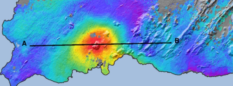
Image credit: IMO
According to the Icelandic Met Office (IMO), unusually rapid inflation has been detected at Mt. Thorbjorn on the Reykjanes Peninsula over the past few days, indicating a possible magma accumulation. In addition, an earthquake swarm has been ongoing during the same period. Authorities have declared Uncertainty phase and raised the Aviation Color Code to Yellow. The last known eruption was during Reykjanes fires, which occurred between 1210 – 1240.
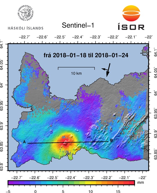
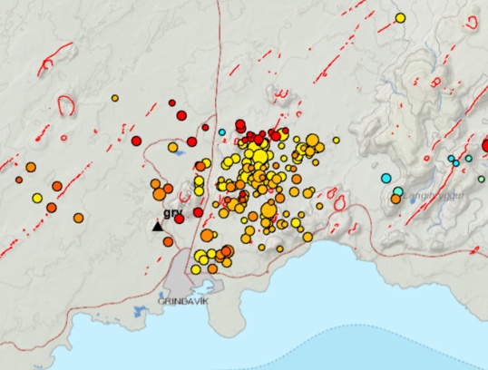
Inflation centered just west of Mt. Thorbjorn accompanied by an earthquake swarm just east of the inflation center (northeast of Grindavík) have been detected since January 21, 2020.
The fact that inflation is occurring alongside the earthquake swarm is a cause for concern and closer monitoring, IMO said.
"The inflation is unusually rapid, around 3 – 4 mm (0.11 – 0.15 inches) per day and has accumulated to 2 cm (0.78 inches) to date. It has been detected both on continuous GPS stations and in InSAR images," the office said, adding that the inflation is most likely a sign of magma accumulation at a depth of just a few km.
Images courtesy: IMO
If magma accumulation is causing the inflation, the accumulation is very small, with the first volume estimate is around 1 million cubic meters (0.001 km3 / 0.0002 mi3). This is the conclusion of a meeting held with the Scientific council of the Civil Protection at the IMO this morning.
Accurate measurements of crustal deformation on the Reykjanes peninsula span approximately three decades. During this period no comparable signal has been measured.
This is unusual for this period, IMO said.
The last known eruption was during Reykjanes fires, which occurred between 1210 and 1240.
"Within that period, several eruptions occurred within that system, thereof there were three eruptions in the Svartsengi system. The eruptions were effusive (non-explosive) fissure eruptions erupting on 1 – 10 km (0.62 – 6.2 miles) long fissures. No explosive eruptions are known from this system. The largest eruption in the swarm, from the 13th century, formed Arnarseturshraun lava (estimated 0.3 km3 / 0.07 mi3 and 20 km2 / 7.72 mi2).
"Historically, the duration of these eruptions spans from a few days up to several weeks. Seismic activity is very common in this area and is linked to the plate boundaries, geothermal activity and possible magma intrusions. The largest earthquakes measured in this area are about M5.5."
Possible scenarios
The activity has only been ongoing for a few days and it is uncertain if it will escalate to more serious activity, IMO said.
Based on current information, the following scenarios are considered possible, without stating which is most likely or within what timeframe.
1. If the inflation is due to magma accumulation:
- Magma accumulation will cease soon without further activity.
- Magma accumulation continues for some time without further activity.
- Magma accumulation will lead to a magma intrusion.
- Magma accumulation will lead to magma intrusion and eruption (effusive fissure eruption).
- Magma accumulation triggers seismic activity with larger earthquakes (up to M6.0).
2. If the inflation is not caused by magma accumulation:
- The inflation might be linked to tectonic activity and lead to larger earthquakes (up to M6.0).
The National Commissioner of the Icelandic Police in cooperation with the Police Commissioner on Reykjanes has declared a state of uncertainty.
A public community meeting will be held in Grindavík on January 27 at 16:00 local time. The situation will be discussed with the Department of Civil Protection, scientists and first responders.
The 24/7 monitoring of the area has been increased at IMO.
Geological summary
The Reykjanes volcanic system at the SW tip of the Reykjanes Peninsula, where the Mid-Atlantic Ridge rises above sea level, comprises a broad area of postglacial basaltic crater rows and small shield volcanoes.
The submarine Reykjaneshryggur volcanic system is contiguous with and is considered part of the Reykjanes volcanic system, which is the westernmost of a series of four closely-spaced en-echelon fissure systems that extend diagonally across the Reykjanes Peninsula.
Most of the subaerial part of the volcanic system (also known as the Reykjanes/Svartsengi volcanic system) is covered by Holocene lavas.
Subaerial eruptions have occurred in historical time during the 13th century at several locations on the NE-SW-trending fissure system, and numerous submarine eruptions at Reykjaneshryggur dating back to the 12th century have been observed during historical time, some of which have formed ephemeral islands.
Basaltic rocks of probable Holocene age have been recovered during dredging operations, and tephra deposits from earlier Holocene eruptions are preserved on the nearby Reykjanes Peninsula. (GVP)
I'm a dedicated researcher, journalist, and editor at The Watchers. With over 20 years of experience in the media industry, I specialize in hard science news, focusing on extreme weather, seismic and volcanic activity, space weather, and astronomy, including near-Earth objects and planetary defense strategies. You can reach me at teo /at/ watchers.news.
Commenting rules and guidelines
We value the thoughts and opinions of our readers and welcome healthy discussions on our website. In order to maintain a respectful and positive community, we ask that all commenters follow these rules.