
Shallow M6.0 earthquake hits Kuril Islands region, Russia
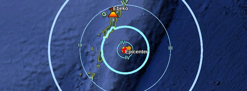
Image credit: Google, USGS, TW
A shallow earthquake registered by the USGS as M6.0 hit the Kuril Islands region, Russia at 07:45 UTC on October 9, 2018. The agency is reporting a depth of 42 km (26 miles). EMSC is reporting M6.0 at a depth of 35 km (21 miles). The quake was followed by M4.5 at 08:07 UTC at a depth of 35 km.
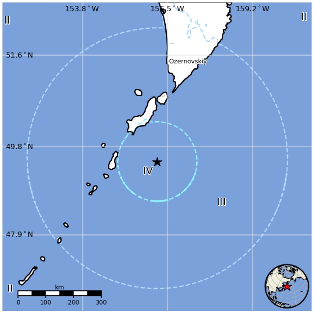
The epicenter was located 138.6 km (86.1 miles) S of Severo-Kuril’sk (population 2 422), Sakhalin and 419 km (260 miles) SSE of Vilyuchinsk (population 25 204), Kamtsjatka, Russia.
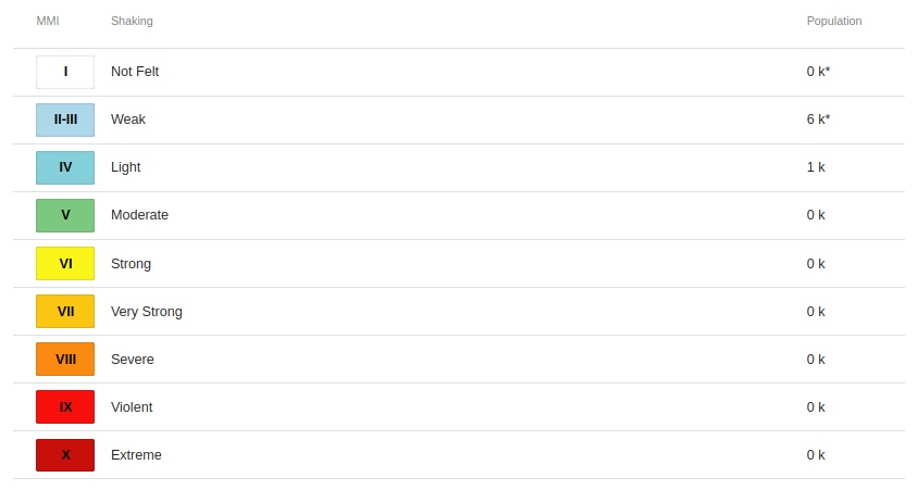
The USGS issued a green alert for shaking-related fatalities and economic losses. There is a low likelihood of casualties and damage.
Overall, the population in this region resides in structures that are resistant to earthquake shaking, though vulnerable structures exist. The predominant vulnerable building types are adobe block and unreinforced brick with mud construction.
Regional seismicity
Seismotectonics of the Kuril-Kamchatka Arc
The Kuril-Kamchatka Arc extends approximately 2,100 km from Hokkaido, Japan along the Kuril Islands and the Pacific coast of the Kamchatka Peninsula, until terminating at its intersection with the Aleutian arc south of the Commander Islands, Russia. It marks the region where the Pacific plate subducts into the mantle beneath the Okhotsk mircoplate, a proposed regional subdivision of the larger North America plate. This subduction is responsible for the generation of the Kuril Islands chain, volcanoes along the entire arc, and the deep Kuril-Kamchatka Trench. Relative to a fixed North America plate, the Pacific plate is moving northwest at a rate that increases from 79 mm/yr near the northern end of the arc to 83 mm/yr adjacent to Hokkaido.
In the southern section of the Kuril arc oblique subduction results in the partitioning of stress into both trench-normal thrust earthquakes (e.g., the 12/03/1995 M 7.9 Kuril Island event) and trench-parallel strike-slip earthquakes (e.g., the 10/16/1994 M 6.7 Kuril Island event). This oblique convergence also drives the southwestern translation of the Kuril Arc, and its collision with the Japan Arc. The collision in turn drives the uplift of the Hidaka Mountains, and causes northwest-southeast oriented compressional earthquakes across Hokkaido.
North of approximately 44° latitude, adjacent to the island of Urup, convergence becomes dominantly trench normal. In this area, cross-sections of the subduction zone reveal a well-defined Wadati-Benioff zone extending to depths of 650 km, supporting assumptions that the Pacific plate is relatively old and has been subducting for close to 100 Myr. As the arc approaches its northern terminus off the coast of the Kamchatka Peninsula, the character of subduction changes again due to the entrainment of the Meiji Seamount and the influence of transform motion along westernmost extent of the Aleutian Arc. The angle of subduction decreases from 55 to 35 degrees from south to north, and the maximum depth of seismicity decreases from ~600 km to ~200 km, causing a northwestern deviation in the volcanic front.
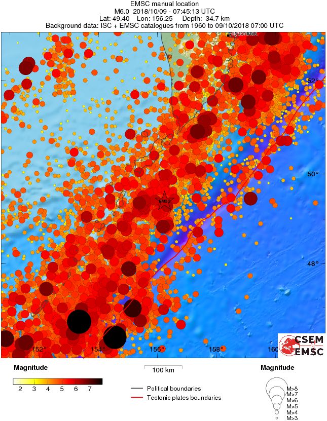
The Kuril-Kamchatka Arc is one of the most seismically active regions in the world. Deformation of the overriding North America plate and associated microplates generates shallow crustal earthquakes, while slip at the subduction zone interface between the Pacific and North America plates generates interplate earthquakes that extend from near the base of the trench to depths of 40 to 60 km. The aftershock zones of great historic earthquakes abut one another along the strike of the arc but generally do not overlap; sections of the subduction zone have typically experienced earthquakes of a consistent size at fairly regular recurrence intervals, though the length of seismicity catalogs is typically shorter than the expected repeat times of the largest earthquakes known to have occurred in the region.
Patterns in along-arc seismicity can reveal seismic gaps, zones where no great ruptures have occurred for an anomalously long period of time. In the Kuril region, a gap between Simushir Island and Onekotan Island that had remained unruptured by a large earthquake since 1780 was the site of an M 8.3 event on November 15, 2006. Minutes after the November 15 earthquake, aftershocks began rupturing one or more faults near the outer rise region seaward of the Kuril-Kamchatka Trench, adjacent to the location of the main shock. On January 13, 2007, two months after the 2006 event, a great (M 8.1) normal faulting earthquake occurred in this same region. Because the January 2007 event ruptured within the aftershock zone of the November 2006 quake, it is speculated to be the result of changes in the regional stress field following the earlier event, despite occurring on a different fault. The inferred coupling of the 2006 and 2007 events make them one of the largest earthquake doublets to have ever been recorded.
The Kuril-Kamchatka region frequently experiences large (M≥7) and great (M≥8) earthquakes. In the 114 years since 1900, 133 large and 12 great earthquakes have occurred along the arc. Damaging tsunamis followed several of the large interplate megathrust earthquakes, including the September 25, 2003 M 8.3 Hokkaido earthquake, and the November 6, 1958 M 8.4 Etorofu event. The February 3, 1923 M 8.4 Kamchatka earthquake generated an 8 m transoceanic tsunami. On October 13, 1963, a M 8.5 megathrust earthquake off the coast of the island of Urup generated a large tsunami in the Pacific Ocean and the Sea of Okhotsk, with run-up wave heights of up to 4-5 m.
The largest megathrust earthquake to occur along the arc in the 20th century was the November 4, 1952 M 9.0 event, to date the 5th largest instrumentally recorded earthquake in history. This earthquake was followed by a devastating tsunami with run-up wave heights as high as 12 m along the coast of Paramushir, causing significant damage to the city of Severo-Kurilsk. Intraplate earthquakes have also been known to cause significant damage in the region. On October 4, 1994, a large (M8.3) intraplate event occurred within the subducted oceanic lithosphere of the Pacific plate off the coast of Shikotan Island, causing intense ground shaking, landslides, and a tsunami with run-up heights of up to 10 m on the island.
While most large earthquakes along the Kuril-Kamchatka Arc occur at shallow or intermediate depths, the region also hosts large events that rupture at depths greater than 300 km. The most significant of these deep-focus earthquakes to date was the May 24, 2013 M 8.3 event beneath the Sea of Okhotsk, currently the largest deep-focus earthquake on record. The earthquake occurred as the result of normal faulting within the subducted Pacific slab approximately 600 km below the Earth's surface, and was felt as far away as Moscow, Russia, nearly 6,500 km to the west. (USGS)
I'm a dedicated researcher, journalist, and editor at The Watchers. With over 20 years of experience in the media industry, I specialize in hard science news, focusing on extreme weather, seismic and volcanic activity, space weather, and astronomy, including near-Earth objects and planetary defense strategies. You can reach me at teo /at/ watchers.news.
Commenting rules and guidelines
We value the thoughts and opinions of our readers and welcome healthy discussions on our website. In order to maintain a respectful and positive community, we ask that all commenters follow these rules.