
Photogenic EF-3 tornado touched down near Laramie, Wyoming
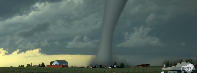
Featured image: Photogenic tornado touches down near Laramie, Wyoming on June 6, 2018. Credit: Live Storms Media
A strong EF-3 tornado touched down near Laramie, Wyoming on June 6, 2018, causing damage to some structures and power lines. There were no injuries reported but the tornado was especially photogenic, one for the history books. Another tornado occurred in the vicinity of the Antelope Ridge subdivision on the same day.
An isolated supercell thunderstorm developed in central Albany County, Wyoming about 13 km (8 miles) north of Laramie during the late afternoon on June 6, 2018. The storm initially produced a tornado 5 – 6.5 km (3 to 4 miles) west of Highway 30.
The tornado tracked east across Highway 30 and intensified rapidly moving through mainly open fields. Numerous wooden power poles were snapped along County Road 121, along with several galvanized steel utility poles which were bent 90 degrees at the base.
Grass was scoured out of the ground in a wide swath approximately 500 m (547 yards) in width near the intersection of County Road 121 and Cattle Drive. This is consistent with an EF-3 tornado.
The tornado was observed to continue east up into the Laramie Range near King Mountain Road for a period of over 45 minutes.
A satellite tornado developed 3.2 km (2 miles) to the south of the parent tornado. This tornado damaged treetops and caused significant structural damage to a well-built attached garage, which collapsed as it lifted off the foundation and shifted to the east. The damage to the garage was consistent with an EF-2 tornado.
In addition, several nearby structures had minor damage to siding and shingles. The tornado was observed moving through the Antelope Ridge Loop subdivision, 10 km (6 miles) north of Laramie, and into open country.
Main Tornado

Rating:                 EF-3
Estimated peak wind:    241 km/h (150 mph)
Path length /Statute/:  18 km (11.3 miles)
Path width /Maximum/:   545 m (600 yards)
Fatalities:             0
Injuries:               0

Start date:             June 06 2018
Start time:             5:43 pm MDT
Start location:         12.8 km (8 miles) North of Laramie, Wyoming
Start Lat/Lon:          41.469, -105.676

End date:               June 06 2018
End time:               6:36 pm MDT
End location:           19.2 km (12 miles) northeast of Laramie, Wyoming
End_lat/lon:            41.469, -105.460

Satellite Tornado

Rating:                 EF-2
Estimated peak wind:    193 km (120 mph)
Path length /Statute/:  960 m (0.6 miles)
Path width /Maximum/:   45.7 m (50 yards)
Fatalities:             0
Injuries:               0

Start date:             June 06 2018
Start time:             5:43 pm MDT
Start location:         9.6 km (6 miles) North of Laramie, Wyoming
Start Lat/Lon:          41.416, -105.605

End date:               June 06 2018
End time:               6:05 pm MDT
End location:           9.6 km (6 miles) North of Laramie, Wyoming
End_lat/lon:            41.416, -105.597

EF Scale: The Enhanced Fujita Scale classifies
tornadoes into the following categories:

EF0...Weak...... 105 to 137 km/h (65 to 85 mph)
EF1...Weak...... 138 to 177 km/h (86 to 110 mph)
EF2...Strong.... 178 to 217 km/h (111 to 135 mph)
EF3...Strong.... 218 to 265 km/h (136 to 165 mph)
EF4...Violent... 266 to 321 km/h (166 To 200 mph)
EF5...Violent... >322 km/h (>200 mph)
I'm a dedicated researcher, journalist, and editor at The Watchers. With over 20 years of experience in the media industry, I specialize in hard science news, focusing on extreme weather, seismic and volcanic activity, space weather, and astronomy, including near-Earth objects and planetary defense strategies. You can reach me at teo /at/ watchers.news.
Commenting rules and guidelines
We value the thoughts and opinions of our readers and welcome healthy discussions on our website. In order to maintain a respectful and positive community, we ask that all commenters follow these rules.