Powerful M7.9 earthquake hits Gulf of Alaska, triggers tsunami warnings
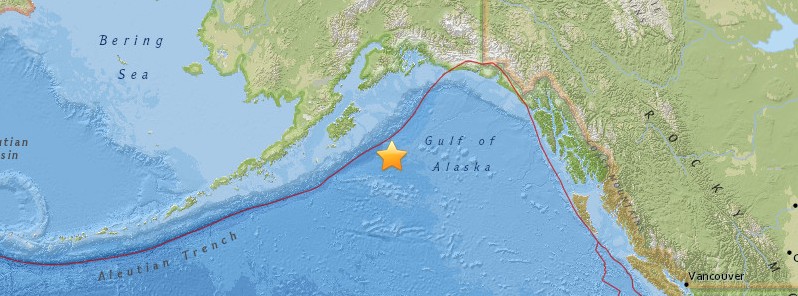
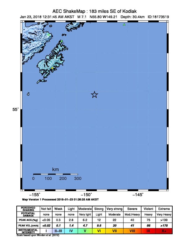
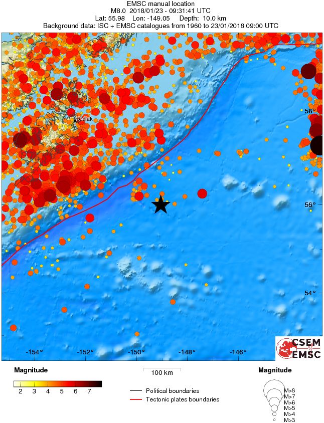
A massive earthquake registered by the USGS as M7.9 hit the Gulf of Alaska at 09:31 UTC on January 23, 2018 (00:31 local time). The agency is reporting a depth of 25 km (15.5 miles). EMSC is reporting M8.0 at a depth of 10 km (6.2 miles). Tsunami warnings, watches and advisories were issued following the quake. Over the next 3 hours, the USGS registered more than 20 aftershocks with magnitudes ranging from 2.5 to 5.3.
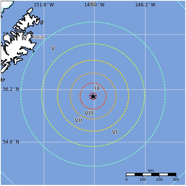
The epicenter was located 260.2 km (161.7 miles) SE of Chiniak (population 47) and 576.7 km (358.3 miles) S of Anchorage (population 291 826), Alaska, United States.
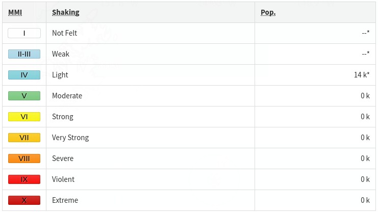
There are no people living within 100 km (62 miles). Some 14 000 people are estimated to have felt 14 000 light shaking.

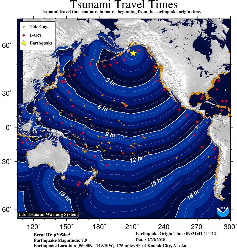
Based on the preliminary earthquake parameters, widespread hazardous tsunami waves are possible, PTWC said 09:43 UTC.
PRELIMINARY EARTHQUAKE PARAMETERS --------------------------------- * MAGNITUDE 8.0 * ORIGIN TIME 0932 UTC JAN 23 2018 * COORDINATES 56.0 NORTH 149.2 WEST * DEPTH 19 KM / 12 MILES * LOCATION GULF OF ALASKA EVALUATION ---------- * AN EARTHQUAKE WITH A PRELIMINARY MAGNITUDE OF 8.0 OCCURRED IN THE GULF OF ALASKA AT 0932 UTC ON TUESDAY JANUARY 23 2018. * BASED ON THE PRELIMINARY EARTHQUAKE PARAMETERS... WIDESPREAD HAZARDOUS TSUNAMI WAVES ARE POSSIBLE. TSUNAMI THREAT FORECAST ----------------------- * HAZARDOUS TSUNAMI WAVES FROM THIS EARTHQUAKE ARE POSSIBLE WITHIN THE NEXT THREE HOURS ALONG SOME COASTS OF NO AREAS COVERED BY THIS MESSAGE APPEAR TO BE IMMEDIATELY THREATENED. HOWEVER... THE SITUATION IS STILL UNDER INVESTIGATION. THIS THREAT EVALUATION WILL BE UPDATED AS SOON AS FURTHER INFORMATION BECOMES AVAILABLE. RECOMMENDED ACTIONS ------------------- * GOVERNMENT AGENCIES RESPONSIBLE FOR THREATENED COASTAL AREAS SHOULD TAKE ACTION TO INFORM AND INSTRUCT ANY COASTAL POPULATIONS AT RISK IN ACCORDANCE WITH THEIR OWN EVALUATION... PROCEDURES AND THE LEVEL OF THREAT. * PERSONS LOCATED IN THREATENED COASTAL AREAS SHOULD STAY ALERT FOR INFORMATION AND FOLLOW INSTRUCTIONS FROM NATIONAL AND LOCAL AUTHORITIES. POTENTIAL IMPACTS ----------------- * A TSUNAMI IS A SERIES OF WAVES. THE TIME BETWEEN WAVE CRESTS CAN VARY FROM 5 MINUTES TO AN HOUR. THE HAZARD MAY PERSIST FOR MANY HOURS OR LONGER AFTER THE INITIAL WAVE. * IMPACTS CAN VARY SIGNIFICANTLY FROM ONE SECTION OF COAST TO THE NEXT DUE TO LOCAL BATHYMETRY AND THE SHAPE AND ELEVATION OF THE SHORELINE. * IMPACTS CAN ALSO VARY DEPENDING UPON THE STATE OF THE TIDE AT THE TIME OF THE MAXIMUM TSUNAMI WAVES. * PERSONS CAUGHT IN THE WATER OF A TSUNAMI MAY DROWN... BE CRUSHED BY DEBRIS IN THE WATER... OR BE SWEPT OUT TO SEA.
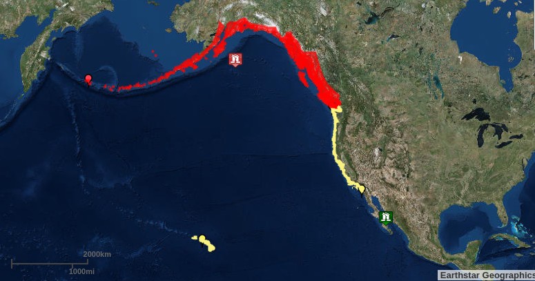
As of 12:35 AKST, a Tsunami Warning is in effect for:
BRITISH COLUMBIA, The Juan de Fuca Strait coast, the outer west coast of Vancouver Island, the central coast and northeast Vancouver Island, and the north coast and Haida Gwaii
SOUTHEAST ALASKA, The inner and outer coast from The BC/Alaska Border to Cape Fairweather, Alaska (80 miles SE of Yakutat)
SOUTH ALASKA AND THE ALASKA PENINSULA, Pacific coasts from Cape Fairweather, Alaska (80 miles SE of Yakutat) to Unimak Pass, Alaska (80 miles NE of Unalaska)
ALEUTIAN ISLANDS, Unimak Pass, Alaska (80 miles NE of Unalaska) to Attu, Alaska including the Pribilof Islands
A Tsunami Watch is in effect for:
CALIFORNIA, The coast from The Cal./Mexico Border to The Oregon/Cal. Border including San Francisco Bay
OREGON, The coast from The Oregon/Cal. Border to The Oregon/Wash. Border including the Columbia River estuary coast
WASHINGTON, Outer coast from the Oregon/Washington border to Slip Point, Columbia River estuary coast, and the Juan de Fuca Strait coast
BULLETIN Public Tsunami Message Number 1 NWS National Tsunami Warning Center Palmer AK 1235 AM AKST Tue Jan 23 2018 ...A TSUNAMI WARNING IS NOW IN EFFECT... ...A TSUNAMI WATCH IS NOW IN EFFECT... Tsunami Warning in Effect for; * BRITISH COLUMBIA, The Juan de Fuca Strait coast, the outer west coast of Vancouver Island, the central coast and northeast Vancouver Island, and the north coast and Haida Gwaii * SOUTHEAST ALASKA, The inner and outer coast from The BC/Alaska Border to Cape Fairweather, Alaska (80 miles SE of Yakutat) * SOUTH ALASKA AND THE ALASKA PENINSULA, Pacific coasts from Cape Fairweather, Alaska (80 miles SE of Yakutat) to Unimak Pass, Alaska (80 miles NE of Unalaska) * ALEUTIAN ISLANDS, Unimak Pass, Alaska (80 miles NE of Unalaska) to Attu, Alaska including the Pribilof Islands Tsunami Watch in Effect for; * CALIFORNIA, The coast from The Cal./Mexico Border to The Oregon/Cal. Border including San Francisco Bay * OREGON, The coast from The Oregon/Cal. Border to The Oregon/Wash. Border including the Columbia River estuary coast * WASHINGTON, Outer coast from the Oregon/Washington border to Slip Point, Columbia River estuary coast, and the Juan de Fuca Strait coast PRELIMINARY EARTHQUAKE PARAMETERS --------------------------------- * The following parameters are based on a rapid preliminary assessment and changes may occur. * Magnitude 8.0 * Origin Time 0032 AKST Jan 23 2018 0132 PST Jan 23 2018 0932 UTC Jan 23 2018 * Coordinates 56.0 North 149.2 West * Depth 12 miles * Location 175 miles SE of Kodiak City, Alaska 365 miles S of Anchorage, Alaska FORECASTS OF TSUNAMI ACTIVITY ----------------------------- * Tsunami activity is forecasted to start at the following locations at the specified times. FORECAST START SITE OF TSUNAMI ---- ---------- * Alaska Kodiak 0145 AKST Jan 23 Seward 0155 AKST Jan 23 Elfin Cove 0155 AKST Jan 23 Sitka 0200 AKST Jan 23 Yakutat 0205 AKST Jan 23 Valdez 0215 AKST Jan 23 Sand Point 0220 AKST Jan 23 Cordova 0225 AKST Jan 23 Unalaska 0240 AKST Jan 23 Homer 0255 AKST Jan 23 Craig 0300 AKST Jan 23 Cold Bay 0300 AKST Jan 23 Adak 0305 AKST Jan 23 Shemya 0350 AKST Jan 23 Saint Paul 0400 AKST Jan 23 * British Columbia Langara 0210 AKST Jan 23 Tofino 0340 AKST Jan 23 * Washington Neah Bay 0455 PST Jan 23 Long Beach 0500 PST Jan 23 Moclips 0500 PST Jan 23 Westport 0510 PST Jan 23 Port Angeles 0530 PST Jan 23 Port Townsend 0555 PST Jan 23 * Oregon Port Orford 0505 PST Jan 23 Charleston 0510 PST Jan 23 Seaside 0510 PST Jan 23 Newport 0515 PST Jan 23 Brookings 0515 PST Jan 23 * California Crescent City 0520 PST Jan 23 Horse Mountain 0525 PST Jan 23 Fort Bragg 0525 PST Jan 23 Monterey 0555 PST Jan 23 San Francisco 0620 PST Jan 23 Port San Luis 0620 PST Jan 23 Santa Barbara 0635 PST Jan 23 Los Angeles Harb 0650 PST Jan 23 Newport Beach 0700 PST Jan 23 La Jolla 0705 PST Jan 23 Oceanside 0705 PST Jan 23 OBSERVATIONS OF TSUNAMI ACTIVITY -------------------------------- * No tsunami observations are available to report. RECOMMENDED ACTIONS ------------------- Actions to protect human life and property will vary within tsunami warning areas. If you are in a tsunami warning area; * Evacuate inland or to higher ground above and beyond designated tsunami hazard zones or move to an upper floor of a multi-story building depending on your situation. * Move out of the water, off the beach, and away from harbors, marinas, breakwaters, bays and inlets. * Be alert to and follow instructions from your local emergency officials because they may have more detailed or specific information for your location. * If you feel a strong earthquake or extended ground rolling take immediate protective actions such as moving inland and/or uphill preferably by foot. * Boat operators, * Where time and conditions permit, move your boat out to sea to a depth of at least 180 feet. * If at sea avoid entering shallow water, harbors, marinas, bays, and inlets to avoid floating and submerged debris and strong currents. * Do not go to the shore to observe the tsunami. * Do not return to the coast until local emergency officials indicate it is safe to do so. If you are in a tsunami watch area; * Prepare to take action and stay alert for further information. IMPACTS ------- Impacts will vary at different locations in the warning areas. If you are in a tsunami warning area; * A tsunami with damaging waves and powerful currents is possible. * Repeated coastal flooding is possible as waves arrive onshore, move inland, and drain back into the ocean. * Strong and unusual waves, currents and inland flooding can drown or injure people and weaken or destroy structures on land and in water. * Water filled with floating or submerged debris that can injure or kill people and weaken or destroy buildings and bridges is possible. * Strong and unusual currents and waves in harbors, marinas, bays, and inlets may be especially destructive. * Some impacts may continue for many hours to days after arrival of the first wave. * The first wave may not be the largest so later waves may be larger. * Each wave may last 5 to 45 minutes as a wave encroaches and recedes. * Coasts facing all directions are threatened because the waves can wrap around islands and headlands and into bays. * Strong shaking or rolling of the ground indicates an earthquake has occurred and a tsunami may be imminent. * A rapidly receding or receded shoreline, unusual waves and sounds, and strong currents are signs of a tsunami. * The tsunami may appear as water moving rapidly out to sea, a gentle rising tide like flood with no breaking wave, as a series of breaking waves, or a frothy wall of water. ADDITIONAL INFORMATION AND NEXT UPDATE -------------------------------------- * Refer to the internet site tsunami.gov for more information. * Pacific coastal residents outside California, Oregon, Washington, British Columbia and Alaska should refer to the Pacific Tsunami Warning Center messages at tsunami.gov. * This message will be updated within 30 minutes. $$
Estimated population exposure to earthquake shaking
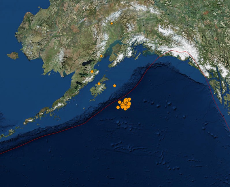
The USGS issued a green alert for shaking-related fatalities and economic losses. There is a low likelihood of casualties and damage.
Overall, the population in this region resides in structures that are resistant to earthquake shaking, though vulnerable structures exist. The predominant vulnerable building types are unreinforced brick masonry and reinforced masonry construction.
Regional seismicity
Updates
At 12:13 UTC (03:13 AKST), the Tsunami Advisory was canceled for the coastal areas of South Alaska and the Alaska Peninsula. Residents are advised not to re-occupy hazard zones until local emergency officials indicate it is safe to do so.
Some areas may continue to see small sea level changes.
BULLETIN Public Tsunami Message Number 7 NWS National Tsunami Warning Center Palmer AK 413 AM AKST Tue Jan 23 2018 ...THE TSUNAMI ADVISORY IS CANCELLED... * The Tsunami Advisory is canceled for the coastal areas of South Alaska and the Alaska Peninsula OBSERVATIONS OF TSUNAMI ACTIVITY - UPDATED ------------------------------------------ * Observed max tsunami height is the highest recorded water level above the tide level up to the time of this message. TIME OBSERVED MAX SITE OF MEASUREMENT TSUNAMI HEIGHT ---------------------------- ---------------- -------------- Kodiak Alaska 0329 PST Jan 23 0.6ft Seward Alaska 0331 PST Jan 23 0.4ft Old Harbor Alaska 0338 PST Jan 23 0.7ft Sitka Alaska 0318 PST Jan 23 0.4ft Yakutat Alaska 0335 PST Jan 23 0.5ft Langara BC 0330 PST Jan 23 0.4ft RECOMMENDED ACTIONS - UPDATED ----------------------------- * Do not re-occupy hazard zones until local emergency officials indicate it is safe to do so. IMPACTS - UPDATED ----------------- * A tsunami was generated by this event, but no longer poses a threat. * Some areas may continue to see small sea level changes. * The determination to re-occupy hazard zones must be made by local officials. ADDITIONAL INFORMATION AND NEXT UPDATE -------------------------------------- * Refer to the internet site tsunami.gov for more information. * Pacific coastal regions outside California, Oregon, Washington, British Columbia, and Alaska should refer to the Pacific Tsunami Warning Center messages at tsunami.gov. * This will be the final U.S. National Tsunami Warning Center message issued for this event. $$
Between 09:31 and 12:48 UTC, the USGS registered a total of 24 earthquakes in this region, including M7.9. Magnitudes ranged from 2.5 to 7.9.
Image credit: USGS
Featured image credit: USGS
If you value what we do here, create your ad-free account and support our journalism.
Your support makes a difference
Dear valued reader,
We hope that our website has been a valuable resource for you.
The reality is that it takes a lot of time, effort, and resources to maintain and grow this website. We rely on the support of readers like you to keep providing high-quality content.
If you have found our website to be helpful, please consider making a contribution to help us continue to bring you the information you need. Your support means the world to us and helps us to keep doing what we love.
Support us by choosing your support level – Silver, Gold or Platinum.
Other support options include Patreon pledges, one-off payments using PayPal and purchasing products from our webshop.
Thank you for your consideration. Your support is greatly appreciated.
Sincerely,
Teo Blašković
Commenting rules and guidelines
We value the thoughts and opinions of our readers and welcome healthy discussions on our website. In order to maintain a respectful and positive community, we ask that all commenters follow these rules:
We reserve the right to remove any comments that violate these rules. By commenting on our website, you agree to abide by these guidelines. Thank you for helping to create a positive and welcoming environment for all.