
Very strong M7.1 earthquake hits near the coast of central Peru
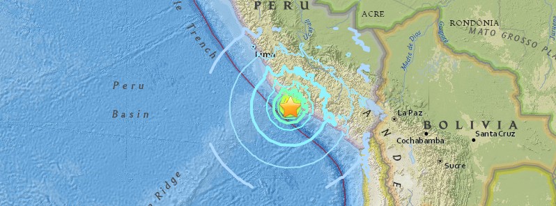
Image credit: USGS
A very strong earthquake registered by the USGS as M7.1 (downgraded from M7.3) hit near the coast of central Peru at 09:18 UTC (04:18 local time) on Sunday, January 14, 2018. The agency is reporting a depth of 36.3 km (22.7 miles). EMSC is reporting M7.1 at a depth of 41 km (25.5 miles).
According to the USGS, the epicenter was located 25.7 km (15.9 miles) SSE of Lomas (population 0) and 73.7 km (45.8 miles) SSE of Minas de Marcona (population 15 468), Peru.
There are about 41 000 people living within 100 km (62 miles).
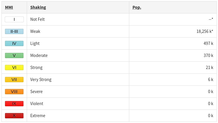
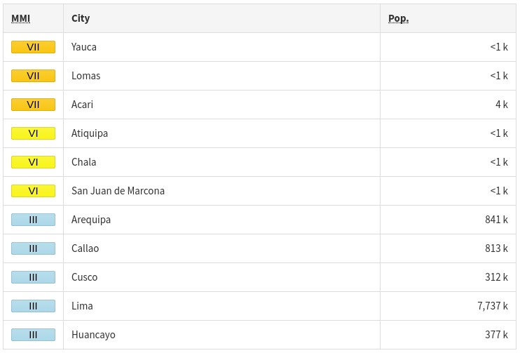
Some 6 000 people are estimated to have felt very strong shaking, 21 000 strong, 37 000 moderate and 497 000 weak.
Based on the preliminary earthquake parameters, hazardous tsunami waves are possible for coasts located within 300 km (186 miles) of the earthquake epicenter, PTWC said 09:26 UTC.
In an updated message issued 10:29 UTC, PTWC said that the tsunami threat from this earthquake has now passed. No tsunami waves were observed on the nearest sea level gauges available.
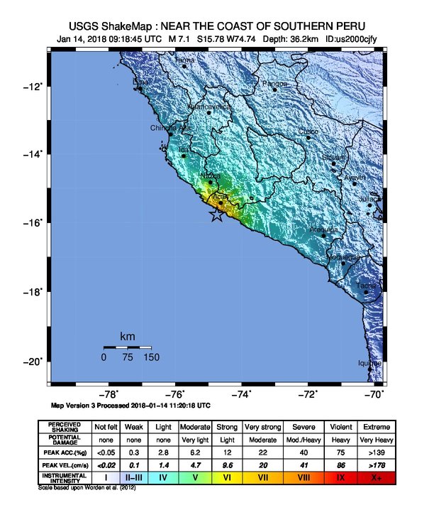
The USGS issued a green alert for shaking-related fatalities.
A yellow alert was issued for economic losses. Some damage is possible and the impact should be relatively localized. Estimated economic losses are less than 1% of GDP of Peru. Past events with this alert level have required a local or regional level response.
Overall, the population in this region resides in structures that are highly vulnerable to earthquake shaking, though some resistant structures exist. The predominant vulnerable building types are mud wall and ductile reinforced concrete frame construction.
Recent earthquakes in this area have caused secondary hazards such as tsunamis and landslides that might have contributed to losses.
Estimated population exposure to earthquake shaking
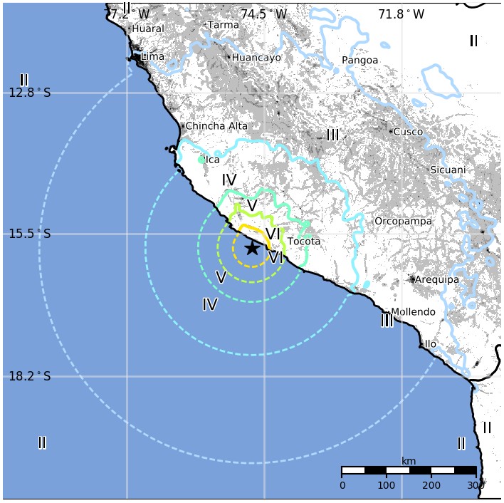
Selected cities exposed
Regional seismicity
Updates
14:28 UTC
At least two people have been killed and 115 injured. In addition, there are reports of at least 17 people missing and 25 houses destroyed.
A 55-year-old man was crushed by a rock in Yauca, Yamila Osorio, governor of the Arequipa region in southern Peru said. The other victim died in the same region, Hernando Tavera, president of the Geophysics Institute of Peru, told TV Peru, without providing further details.
Más fotografías y últimas noticias sobre el reciente #terremoto de 7.1 ML ocurrido frente a costas Arequipeñas. Se confirma segundo fallecido en distrito de #BellaUnión y más de 100 heridos hasta el momento.
Capturas: Frase Corta Arequipa – Santiago Neyra#Arequipa #Acarí #Chala pic.twitter.com/Z4Jy4OCNkN— Julio Montenegro G. (@Juliohydraulics) January 14, 2018
Tectonic summary
The January 14, 2018, M7.1 earthquake offshore southern Peru occurred as the result of shallow thrust faulting on or near the boundary between the South America plate and the subducting Nazca plate.
The Nazca plate subducts beneath the South America plate at the Peru-Chile Trench offshore of western South America, 80 km (50 miles) to the southwest of today’s earthquake, and dips east-northeast beneath the South American continent. At the location of the January 14, 2018 earthquake, the Nazca plate moves to the east-northeast with respect to the South America plate at a velocity of about 70 mm/yr. The location, depth and focal mechanism solution of today’s earthquake are consistent with it occurring on the megathrust interface between the two plates.
While commonly plotted as points on maps, earthquakes of this size are more appropriately described as slip over a larger fault area. Thrust-faulting events of the size of the January 14, 2018 earthquake are typically about 50×25 km / 31 x 15.5 miles (length x width).
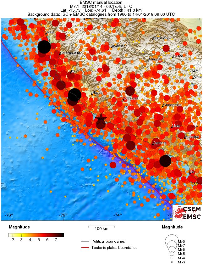
The plate boundary region between the Nazca and South America plates experiences a large number of earthquakes.
The region within 250 km (155 miles) of the epicenter of the January 14 earthquake has experienced 13 previous earthquakes of M6.5+ over the preceding century. The largest of these, the M8.4 earthquake of June 23, 2001, occurred along the plate boundary 130 km (81 miles) to the southeast (and ruptured from there ~ 200 km / 124 miles to the southeast). It resulted in at least 74 fatalities and destroyed more than 17 000 homes.
The epicenter of the M7.7 earthquake of November 12, 1996, is about 130 km (81 miles) to the northwest of today’s earthquake. That event ruptured much of the megathrust between its epicenter and the epicenter of the January 14, 2018 earthquake, and resulted in at least 14 fatalities and left 12 000 people homeless.
The September 25, 2013, M7.1 earthquake, just 25 km (15.5 miles) to the southeast of today’s event, is not known to have caused any fatalities.
Seismotectonics of South America (Nazca Plate Region)
The South American arc extends over 7,000 km, from the Chilean margin triple junction offshore of southern Chile to its intersection with the Panama fracture zone, offshore of the southern coast of Panama in Central America. It marks the plate boundary between the subducting Nazca plate and the South America plate, where the oceanic crust and lithosphere of the Nazca plate begin their descent into the mantle beneath South America. The convergence associated with this subduction process is responsible for the uplift of the Andes Mountains, and for the active volcanic chain present along much of this deformation front. Relative to a fixed South America plate, the Nazca plate moves slightly north of eastwards at a rate varying from approximately 80 mm/yr in the south to approximately 65 mm/yr in the north. Although the rate of subduction varies little along the entire arc, there are complex changes in the geologic processes along the subduction zone that dramatically influence volcanic activity, crustal deformation, earthquake generation and occurrence all along the western edge of South America.
Most of the large earthquakes in South America are constrained to shallow depths of 0 to 70 km resulting from both crustal and interplate deformation. Crustal earthquakes result from deformation and mountain building in the overriding South America plate and generate earthquakes as deep as approximately 50 km. Interplate earthquakes occur due to slip along the dipping interface between the Nazca and the South American plates. Interplate earthquakes in this region are frequent and often large, and occur between the depths of approximately 10 and 60 km. Since 1900, numerous magnitude 8 or larger earthquakes have occurred on this subduction zone interface that were followed by devastating tsunamis, including the 1960 M9.5 earthquake in southern Chile, the largest instrumentally recorded earthquake in the world. Other notable shallow tsunami-generating earthquakes include the 1906 M8.5 earthquake near Esmeraldas, Ecuador, the 1922 M8.5 earthquake near Coquimbo, Chile, the 2001 M8.4 Arequipa, Peru earthquake, the 2007 M8.0 earthquake near Pisco, Peru, and the 2010 M8.8 Maule, Chile earthquake located just north of the 1960 event.
Large intermediate-depth earthquakes (those occurring between depths of approximately 70 and 300 km) are relatively limited in size and spatial extent in South America, and occur within the Nazca plate as a result of internal deformation within the subducting plate. These earthquakes generally cluster beneath northern Chile and southwestern Bolivia, and to a lesser extent beneath northern Peru and southern Ecuador, with depths between 110 and 130 km. Most of these earthquakes occur adjacent to the bend in the coastline between Peru and Chile. The most recent large intermediate-depth earthquake in this region was the 2005 M7.8 Tarapaca, Chile earthquake.
Earthquakes can also be generated to depths greater than 600 km as a result of continued internal deformation of the subducting Nazca plate. Deep-focus earthquakes in South America are not observed from a depth range of approximately 300 to 500 km. Instead, deep earthquakes in this region occur at depths of 500 to 650 km and are concentrated into two zones: one that runs beneath the Peru-Brazil border and another that extends from central Bolivia to central Argentina. These earthquakes generally do not exhibit large magnitudes. An exception to this was the 1994 Bolivian earthquake in northwestern Bolivia. This M8.2 earthquake occurred at a depth of 631 km, which was until recently the largest deep-focus earthquake instrumentally recorded (superseded in May 2013 by a M8.3 earthquake 610 km beneath the Sea of Okhotsk, Russia), and was felt widely throughout South and North America.
Subduction of the Nazca plate is geometrically complex and impacts the geology and seismicity of the western edge of South America. The intermediate-depth regions of the subducting Nazca plate can be segmented into five sections based on their angle of subduction beneath the South America plate. Three segments are characterized by steeply dipping subduction; the other two by near-horizontal subduction. The Nazca plate beneath northern Ecuador, southern Peru to northern Chile, and southern Chile descend into the mantle at angles of 25° to 30°. In contrast, the slab beneath southern Ecuador to central Peru, and under central Chile, is subducting at a shallow angle of approximately 10° or less. In these regions of “flat-slab” subduction, the Nazca plate moves horizontally for several hundred kilometers before continuing its descent into the mantle, and is shadowed by an extended zone of crustal seismicity in the overlying South America plate. Although the South America plate exhibits a chain of active volcanism resulting from the subduction and partial melting of the Nazca oceanic lithosphere along most of the arc, these regions of inferred shallow subduction correlate with an absence of volcanic activity. (USGS)
I'm a dedicated researcher, journalist, and editor at The Watchers. With over 20 years of experience in the media industry, I specialize in hard science news, focusing on extreme weather, seismic and volcanic activity, space weather, and astronomy, including near-Earth objects and planetary defense strategies. You can reach me at teo /at/ watchers.news.
Have you checked out dutchsinse on YouTube? He gives a great explanation and commentary on earthquakes