
Very strong M7.0 earthquake hits New Caledonia, small tsunami produced
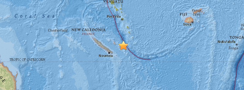
Image credit: USGS
A very strong and shallow earthquake registered by the USGS as M7.0 hit the Loyalty Islands, New Caledonia at 22:43 UTC (09:43 local time) on November 19, 2017. The agency is reporting a depth of 10 km (6.2 miles). EMSC is reporting M7.0 at a depth of 12 km (7.4 miles). This is the second M6+ earthquake to hit this region today.
Hazardous tsunami waves from this earthquake are possible within 300 km (186 miles) of the epicenter along the coasts of Vanuatu and New Caledonia, PTWC said 22:50 UTC.
ESTIMATED TIMES OF ARRIVAL
--------------------------

  * ESTIMATED TIMES OF ARRIVAL -ETA- OF THE INITIAL TSUNAMI WAVE
    FOR PLACES WITH A POTENTIAL TSUNAMI THREAT. ACTUAL ARRIVAL
    TIMES MAY DIFFER AND THE INITIAL WAVE MAY NOT BE THE
    LARGEST. A TSUNAMI IS A SERIES OF WAVES AND THE TIME BETWEEN
    WAVES CAN BE FIVE MINUTES TO ONE HOUR.

    LOCATION         REGION             COORDINATES    ETA(UTC)
    ------------------------------------------------------------
    ANATOM ISLAND    VANUATU           20.2S 169.9E   2305 11/19
    NOUMEA           NEW CALEDONIA     22.3S 166.5E   2355 11/19


POTENTIAL IMPACTS
-----------------

  * A TSUNAMI IS A SERIES OF WAVES. THE TIME BETWEEN WAVE CRESTS
    CAN VARY FROM 5 MINUTES TO AN HOUR. THE HAZARD MAY PERSIST
    FOR MANY HOURS OR LONGER AFTER THE INITIAL WAVE.

  * IMPACTS CAN VARY SIGNIFICANTLY FROM ONE SECTION OF COAST TO
    THE NEXT DUE TO LOCAL BATHYMETRY AND THE SHAPE AND ELEVATION
    OF THE SHORELINE.

  * IMPACTS CAN ALSO VARY DEPENDING UPON THE STATE OF THE TIDE AT
    THE TIME OF THE MAXIMUM TSUNAMI WAVES.

  * PERSONS CAUGHT IN THE WATER OF A TSUNAMI MAY DROWN... BE
    CRUSHED BY DEBRIS IN THE WATER... OR BE SWEPT OUT TO SEA.
From PTWC Threat Message issued 23:18 UTC:
TSUNAMI THREAT FORECAST...UPDATED
---------------------------------

  * TSUNAMI WAVES REACHING 0.3 TO 1 METERS ABOVE THE TIDE LEVEL
    ARE POSSIBLE FOR SOME COASTS OF

      NEW CALEDONIA.


  * TSUNAMI WAVES ARE FORECAST TO BE LESS THAN 0.3 METERS ABOVE
    THE TIDE LEVEL FOR THE COASTS OF

      VANUATU.


  * ACTUAL AMPLITUDES AT THE COAST MAY VARY FROM FORECAST
    AMPLITUDES DUE TO UNCERTAINTIES IN THE FORECAST AND LOCAL
    FEATURES. IN PARTICULAR MAXIMUM TSUNAMI AMPLITUDES ON ATOLLS
    AND AT LOCATIONS WITH FRINGING OR BARRIER REEFS WILL LIKELY
    BE MUCH SMALLER THAN THE FORECAST INDICATES.

  * FOR OTHER AREAS COVERED BY THIS PRODUCT A FORECAST HAS NOT
    YET BEEN COMPUTED. THE FORECAST WILL BE EXPANDED IF
    NECESSARY IN SUBSEQUENT PRODUCTS.


RECOMMENDED ACTIONS
-------------------

  * GOVERNMENT AGENCIES RESPONSIBLE FOR THREATENED COASTAL AREAS
    SHOULD TAKE ACTION TO INFORM AND INSTRUCT ANY COASTAL
    POPULATIONS AT RISK IN ACCORDANCE WITH THEIR OWN
    EVALUATION... PROCEDURES AND THE LEVEL OF THREAT.

  * PERSONS LOCATED IN THREATENED COASTAL AREAS SHOULD STAY ALERT
    FOR INFORMATION AND FOLLOW INSTRUCTIONS FROM NATIONAL AND
    LOCAL AUTHORITIES.


ESTIMATED TIMES OF ARRIVAL
--------------------------

  * ESTIMATED TIMES OF ARRIVAL -ETA- OF THE INITIAL TSUNAMI WAVE
    FOR PLACES WITHIN THREATENED REGIONS ARE GIVEN BELOW. ACTUAL
    ARRIVAL TIMES MAY DIFFER AND THE INITIAL WAVE MAY NOT BE THE
    LARGEST. A TSUNAMI IS A SERIES OF WAVES AND THE TIME BETWEEN
    WAVES CAN BE FIVE MINUTES TO ONE HOUR.

    LOCATION         REGION             COORDINATES    ETA(UTC)
    ------------------------------------------------------------
    NOUMEA           NEW CALEDONIA     22.3S 166.5E   2352 11/19


POTENTIAL IMPACTS
-----------------

  * A TSUNAMI IS A SERIES OF WAVES. THE TIME BETWEEN WAVE CRESTS
    CAN VARY FROM 5 MINUTES TO AN HOUR. THE HAZARD MAY PERSIST
    FOR MANY HOURS OR LONGER AFTER THE INITIAL WAVE.

  * IMPACTS CAN VARY SIGNIFICANTLY FROM ONE SECTION OF COAST TO
    THE NEXT DUE TO LOCAL BATHYMETRY AND THE SHAPE AND ELEVATION
    OF THE SHORELINE.

  * IMPACTS CAN ALSO VARY DEPENDING UPON THE STATE OF THE TIDE AT
    THE TIME OF THE MAXIMUM TSUNAMI WAVES.

  * PERSONS CAUGHT IN THE WATER OF A TSUNAMI MAY DROWN... BE
    CRUSHED BY DEBRIS IN THE WATER... OR BE SWEPT OUT TO SEA.


NEXT UPDATE AND ADDITIONAL INFORMATION
--------------------------------------

  * THE NEXT MESSAGE WILL BE ISSUED IN ONE HOUR... OR SOONER IF
    THE SITUATION WARRANTS.
From PTWC Threat Message issued 23:23 UTC:
TSUNAMI OBSERVATIONS
--------------------

  * THE FOLLOWING ARE TSUNAMI WAVE OBSERVATIONS FROM COASTAL
    AND/OR DEEP-OCEAN SEA LEVEL GAUGES AT THE INDICATED
    LOCATIONS. THE MAXIMUM TSUNAMI HEIGHT IS MEASURED WITH
    RESPECT TO THE NORMAL TIDE LEVEL.

                            GAUGE      TIME OF   MAXIMUM     WAVE
                         COORDINATES   MEASURE   TSUNAMI   PERIOD
    GAUGE LOCATION        LAT   LON     (UTC)     HEIGHT    (MIN)
    -------------------------------------------------------------
    LENAKEL VU           19.5S 169.3E    2309   0.20M/ 0.7FT  06
    LIFOU NEW CALEDONIA  20.9S 167.3E    2305   0.19M/ 0.6FT  06
    MARE NEW CALEDONIA   21.5S 167.9E    2307   0.25M/ 0.8FT  06
From PTWC Final Threat Message issued 00:07 UTC:
TSUNAMI THREAT FORECAST...UPDATED
---------------------------------
* THE TSUNAMI THREAT HAS NOW LARGELY PASSED.
RECOMMENDED ACTIONS
-------------------
* GOVERNMENT AGENCIES RESPONSIBLE FOR ANY IMPACTED COASTAL
AREAS SHOULD MONITOR CONDITIONS AT THE COAST TO DETERMINE IF
AND WHEN IT IS SAFE TO RESUME NORMAL ACTIVITIES.
* PERSONS LOCATED NEAR IMPACTED COASTAL AREAS SHOULD STAY ALERT
FOR INFORMATION AND FOLLOW INSTRUCTIONS FROM LOCAL
AUTHORITIES.
* REMAIN OBSERVANT AND EXERCISE NORMAL CAUTION NEAR THE SEA.
POTENTIAL IMPACTS
-----------------
* MINOR SEA LEVEL FLUCTUATIONS OF UP TO 0.3 METERS ABOVE AND
BELOW THE NORMAL TIDE MAY CONTINUE OVER THE NEXT FEW HOURS.
TSUNAMI OBSERVATIONS
--------------------
* THE FOLLOWING ARE TSUNAMI WAVE OBSERVATIONS FROM COASTAL
AND/OR DEEP-OCEAN SEA LEVEL GAUGES AT THE INDICATED
LOCATIONS. THE MAXIMUM TSUNAMI HEIGHT IS MEASURED WITH
RESPECT TO THE NORMAL TIDE LEVEL.
GAUGE TIME OF MAXIMUM WAVE
COORDINATES MEASURE TSUNAMI PERIOD
GAUGE LOCATION LAT LON (UTC) HEIGHT (MIN)
-------------------------------------------------------------
THIO NEW CALEDONIA 21.6S 166.2E 2346 0.09M/ 0.3FT 10
OUINNE NEW CALEDONI 22.0S 166.7E 2342 0.37M/ 1.2FT 06
MARE NEW CALEDONIA 21.5S 167.9E 2329 0.28M/ 0.9FT 06
LENAKEL VU 19.5S 169.3E 2314 0.22M/ 0.7FT 04
LIFOU NEW CALEDONIA 20.9S 167.3E 2305 0.19M/ 0.6FT 06
NEXT UPDATE AND ADDITIONAL INFORMATION
--------------------------------------
* THIS WILL BE THE FINAL STATEMENT ISSUED FOR THIS EVENT UNLESS
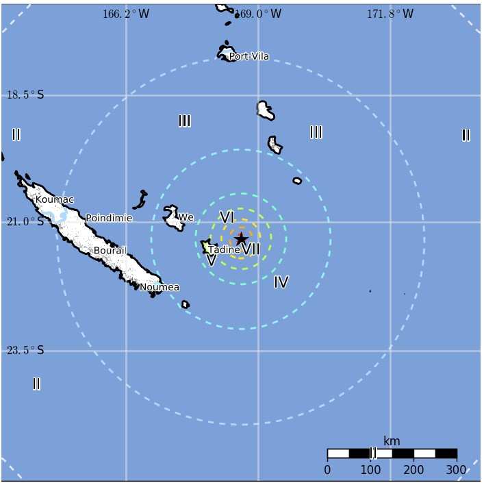
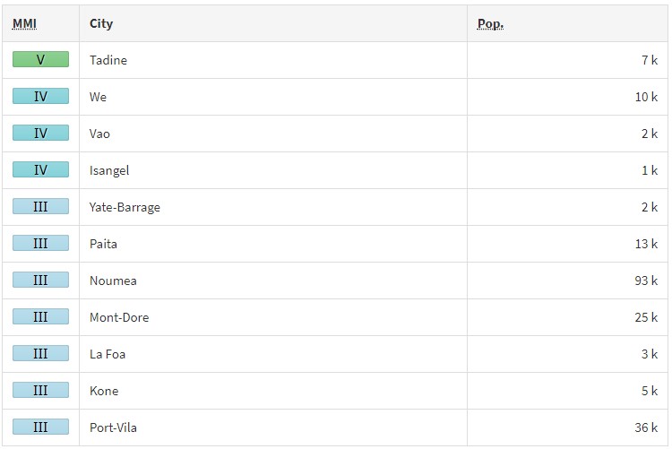
NEW INFORMATION IS RECEIVED OR THE SITUATION CHANGES.According to the USGS, the epicenter was located 82.2 km (51.1 miles) ENE of Tadine (population 7 492) and 149.9 km (93.1 miles) ESE of Wé (population 10 375), New Caledonia.
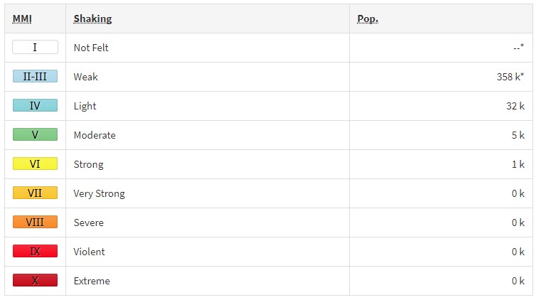
There are about 5 000 people living within 100 km (62 miles). Some 1 000 people are estimated to have felt strong shaking and 5 000 moderate.
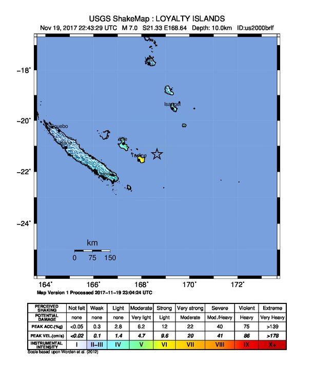
The USGS issued a green alert for shaking-related fatalities and economic losses. There is a low likelihood of casualties and damage.
Overall, the population in this region resides in structures that are highly vulnerable to earthquake shaking, though some resistant structures exist. The predominant vulnerable building types are unknown/miscellaneous types and wood construction.
Recent earthquakes in this area have caused secondary hazards such as tsunamis that might have contributed to losses.
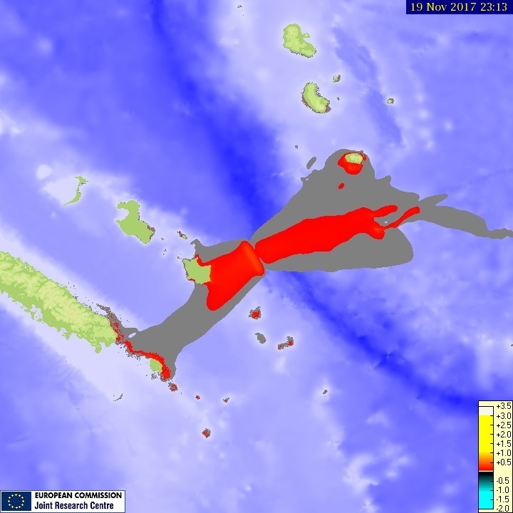
Tsunami maximum wave height
Estimated population exposure to earthquake shaking
Selected cities exposed
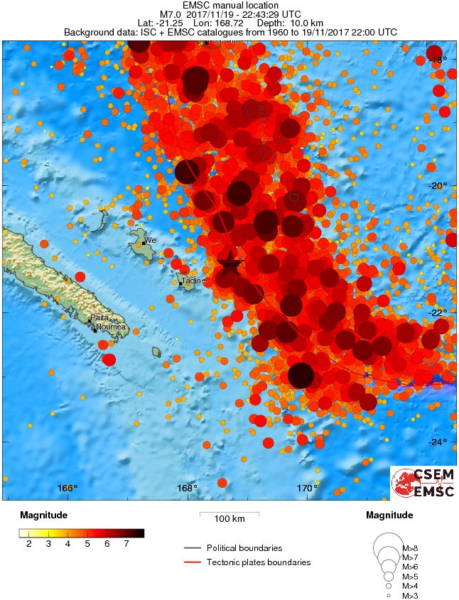
Regional seismicity
Seismotectonics of the eastern margin of the Australia plate
The eastern margin of the Australia plate is one of the most seismically active areas of the world due to high rates of convergence between the Australia and Pacific plates. In the region of New Zealand, the 3000 km long Australia-Pacific plate boundary extends from south of Macquarie Island to the southern Kermadec Island chain. It includes an oceanic transform (the Macquarie Ridge), two oppositely verging subduction zones (Puysegur and Hikurangi), and a transpressive continental transform, the Alpine Fault through South Island, New Zealand.
Since 1900 there have been 15 M7.5+ earthquakes recorded near New Zealand. Nine of these, and the four largest, occurred along or near the Macquarie Ridge, including the 1989 M8.2 event on the ridge itself, and the 2004 M8.1 event 200 km to the west of the plate boundary, reflecting intraplate deformation. The largest recorded earthquake in New Zealand itself was the 1931 M7.8 Hawke's Bay earthquake, which killed 256 people. The last M7.5+ earthquake along the Alpine Fault was 170 years ago; studies of the faults' strain accumulation suggest that similar events are likely to occur again.
North of New Zealand, the Australia-Pacific boundary stretches east of Tonga and Fiji to 250 km south of Samoa. For 2,200 km the trench is approximately linear, and includes two segments where old (>120 Myr) Pacific oceanic lithosphere rapidly subducts westward (Kermadec and Tonga). At the northern end of the Tonga trench, the boundary curves sharply westward and changes along a 700 km-long segment from trench-normal subduction, to oblique subduction, to a left lateral transform-like structure.
Australia-Pacific convergence rates increase northward from 60 mm/yr at the southern Kermadec trench to 90 mm/yr at the northern Tonga trench; however, significant back arc extension (or equivalently, slab rollback) causes the consumption rate of subducting Pacific lithosphere to be much faster. The spreading rate in the Havre trough, west of the Kermadec trench, increases northward from 8 to 20 mm/yr. The southern tip of this spreading center is propagating into the North Island of New Zealand, rifting it apart. In the southern Lau Basin, west of the Tonga trench, the spreading rate increases northward from 60 to 90 mm/yr, and in the northern Lau Basin, multiple spreading centers result in an extension rate as high as 160 mm/yr. The overall subduction velocity of the Pacific plate is the vector sum of Australia-Pacific velocity and back arc spreading velocity: thus it increases northward along the Kermadec trench from 70 to 100 mm/yr, and along the Tonga trench from 150 to 240 mm/yr.
The Kermadec-Tonga subduction zone generates many large earthquakes on the interface between the descending Pacific and overriding Australia plates, within the two plates themselves and, less frequently, near the outer rise of the Pacific plate east of the trench. Since 1900, 40 M7.5+ earthquakes have been recorded, mostly north of 30°S. However, it is unclear whether any of the few historic M8+ events that have occurred close to the plate boundary were underthrusting events on the plate interface, or were intraplate earthquakes. On September 29, 2009, one of the largest normal fault (outer rise) earthquakes ever recorded (M8.1) occurred south of Samoa, 40 km east of the Tonga trench, generating a tsunami that killed at least 180 people.
Across the North Fiji Basin and to the west of the Vanuatu Islands, the Australia plate again subducts eastwards beneath the Pacific, at the North New Hebrides trench. At the southern end of this trench, east of the Loyalty Islands, the plate boundary curves east into an oceanic transform-like structure analogous to the one north of Tonga.
Australia-Pacific convergence rates increase northward from 80 to 90 mm/yr along the North New Hebrides trench, but the Australia plate consumption rate is increased by extension in the back arc and in the North Fiji Basin. Back arc spreading occurs at a rate of 50 mm/yr along most of the subduction zone, except near ~15°S, where the D'Entrecasteaux ridge intersects the trench and causes localized compression of 50 mm/yr in the back arc. Therefore, the Australia plate subduction velocity ranges from 120 mm/yr at the southern end of the North New Hebrides trench, to 40 mm/yr at the D'Entrecasteaux ridge-trench intersection, to 170 mm/yr at the northern end of the trench.
Large earthquakes are common along the North New Hebrides trench and have mechanisms associated with subduction tectonics, though occasional strike slip earthquakes occur near the subduction of the D'Entrecasteaux ridge. Within the subduction zone 34 M7.5+ earthquakes have been recorded since 1900. On October 7, 2009, a large interplate thrust fault earthquake (M7.6) in the northern North New Hebrides subduction zone was followed 15 minutes later by an even larger interplate event (M7.8) 60 km to the north. It is likely that the first event triggered the second of the so-called earthquake "doublet". (USGS)
I'm a dedicated researcher, journalist, and editor at The Watchers. With over 20 years of experience in the media industry, I specialize in hard science news, focusing on extreme weather, seismic and volcanic activity, space weather, and astronomy, including near-Earth objects and planetary defense strategies. You can reach me at teo /at/ watchers.news.
Commenting rules and guidelines
We value the thoughts and opinions of our readers and welcome healthy discussions on our website. In order to maintain a respectful and positive community, we ask that all commenters follow these rules.