
Drone views steam plumes inside the crater of Agung volcano, Bali
Featured image: Steam rising from the crater of Mount Agung, Bali, Indonesia - October 21, 2017. Credit: Sutopo Purwo Nugroho / BNPB
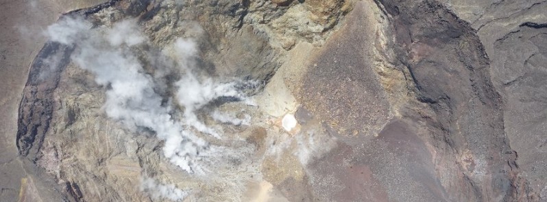
On Thursday, October 19, a surveillance drone detected that the fracture in the crater of Agung volcano, Bali, Indonesia had widened since the satellite image taken Wednesday. While seismic activity under Agung is still increased, the seismic energy continues to decline. Authorities are urging people to stop spreading fake news, adding Bali is safe four tourists.
"The fracture is located on the eastern side of the volcano," BNPB's spokesman Sutopo Purwo Nugroho said, as reported by The Jakarta Post.
"The sulfuric gases emanating from the fracture are also denser than before,” he said yesterday, adding that the drone's photos also revealed a small fracture in the southeastern part of the crater.
Beautiful drone Tawon1.8 IOF-BNPB video of the #Agung crater showing where the steam plumes are coming from. pic.twitter.com/zI5gLh5j4k
— Sutopo Purwo Nugroho (@Sutopo_BNPB) October 21, 2017
Drone Tawon 1.8 videokan kawah Gunung Agung. Rekahan di dinding sisi timur-timur laut terus keluarkan gas solfatara. Status Awas (level 4). pic.twitter.com/lI0kpbNtjG
— Sutopo Purwo Nugroho (@Sutopo_BNPB) October 20, 2017
Mount Agung seismic energy continues to decline. The highest energy was 22-9-2017, when raised to Alert 4. After that it was downhill. pic.twitter.com/zdaPDSm0Ui
— Sutopo Purwo Nugroho (@Sutopo_BNPB) October 16, 2017
Kondisi kawah Gunung Agung dari hasil foto drone Deru buatan UGM. Asap solfara keluar dari rekahan kawah pada 21-10-2017. pic.twitter.com/AFSYKFoWDV
— Sutopo Purwo Nugroho (@Sutopo_BNPB) October 21, 2017
While seismic activity under Agung is still increased, the seismic energy continues to decline. "The highest energy was on September 22, 2017, when the status was raised to 4. After that it was downhill," Nugroho said.
On numerous occasions, Nugroho urged people to stop spreading fake news, adding Bali is safe four tourists.
Mount Agung is located on the east side of Bali. The volcano is about 70 km (43 miles) from the main tourist areas of Kuta and Seminyak, which remain unaffected for now.
Really, Bali is safe. I'm in Bali now. pic.twitter.com/KJecgrRiLZ
— Sutopo Purwo Nugroho (@Sutopo_BNPB) October 19, 2017
Geological summary
Symmetrical Agung stratovolcano, Bali's highest and most sacred mountain, towers over the eastern end of the island. The volcano, whose name means " Paramount," rises above the SE caldera rim of neighboring Batur volcano, and the northern and southern flanks of Agung extend to the coast.
The 3142-m-high (10 308 feet) summit contains a steep-walled, 500-m-wide (1 640 feet), 200-m-deep (656 feet) crater. The flank cone Pawon is located low on the SE side.
Only a few eruptions dating back to the early 19th century have been recorded in historical time. The 1963-64 eruption, one of the world's largest of the 20th century, produced voluminous ashfall along with devastating pyroclastic flows and lahars that caused extensive damage and many fatalities. (GVP)
I'm a dedicated researcher, journalist, and editor at The Watchers. With over 20 years of experience in the media industry, I specialize in hard science news, focusing on extreme weather, seismic and volcanic activity, space weather, and astronomy, including near-Earth objects and planetary defense strategies. You can reach me at teo /at/ watchers.news.
Commenting rules and guidelines
We value the thoughts and opinions of our readers and welcome healthy discussions on our website. In order to maintain a respectful and positive community, we ask that all commenters follow these rules.