
Alert level for Agung volcano raised to highest (4 of 4), Bali
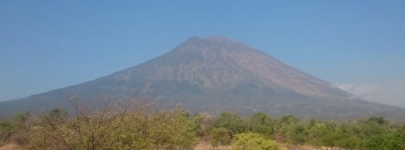
Featured image: Agung volcano - September 22, 2017. Credit: BPBP, Sutopo Purwo Nugroho
Following a sharp increase in seismic activity, Indonesian authorities have raised the alert level for Agung volcano in Bali from 3 to 4 (of 4) at 20:30 local time (13:30 UTC) on September 22, 2017. Massive evacuation of communities around the volcano is in progress.
Nearly 6 000 people were evacuated from villages near the volcano, according to media reports. BNPB's spokesperson, Sutopo Purwo Nugroho, said many of the residents are independently evacuating to the city of Klungkung.
Warga Kec Rendang Kab Karangasem evakuasi mandiri ke Kota Klungkung pasca ditetapkan status Awas Gunung Agung. pic.twitter.com/21bRFkNPsw
— Sutopo Purwo Nugroho (@Sutopo_BNPB) September 22, 2017
While seismicity is still elevated and smoke can be seen above the crater, the eruption has not yet started. There are, however, indications of magma rising to the surface.
Authorities warned residents and tourists that no activity is allowed within 9 km (5.6 miles) from the crater, and within 12 km (7.4 miles) to the north, northeast, southeast and south-southwest.
Residents are asked to remain calm and not to trust unverified sources.
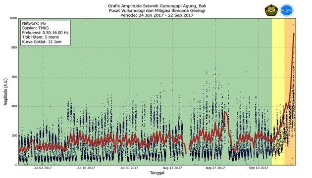
PVMBG first raised the alert level to 2 on September 14 and to 3 on September 18.
The last eruption of this volcano started in February 1963 and ended in January 1964. This was one of the world's largest eruptions of the 20th century (VEI 5). It produced voluminous ashfall along with devastating pyroclastic flows and lahars that caused extensive damage and some 1 100 fatalities.
Geological summary
Symmetrical Agung stratovolcano, Bali's highest and most sacred mountain, towers over the eastern end of the island. The volcano, whose name means "Paramount," rises above the SE caldera rim of neighboring Batur volcano, and the northern and southern flanks of Agung extend to the coast.
The 3142-m-high (10 308 feet) summit contains a steep-walled, 500-m-wide (1 640 feet), 200-m-deep (656 feet) crater. The flank cone Pawon is located low on the SE side.
Only a few eruptions dating back to the early 19th century have been recorded in historical time. The 1963-64 eruption, one of the world's largest of the 20th century, produced voluminous ashfall along with devastating pyroclastic flows and lahars that caused extensive damage and many fatalities. (GVP)
I'm a dedicated researcher, journalist, and editor at The Watchers. With over 20 years of experience in the media industry, I specialize in hard science news, focusing on extreme weather, seismic and volcanic activity, space weather, and astronomy, including near-Earth objects and planetary defense strategies. You can reach me at teo /at/ watchers.news.
Commenting rules and guidelines
We value the thoughts and opinions of our readers and welcome healthy discussions on our website. In order to maintain a respectful and positive community, we ask that all commenters follow these rules.