
Irma for the history books: Meteorological records and most notable facts
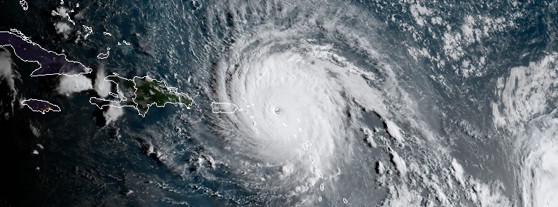
Featured image: Hurricane "Irma" at 11:30 UTC on September 6, 2017. Credit: NOAA/GOES-16 (preliminary and non-operational)
Irma was born as a tropical storm on August 30, 2017 and became a hurricane on August 31. It then rapidly intensified into Category 5 hurricane and passed over several Caribbean islands, destroying everything in its path. It made landfall over Cudjoe Key in the lower Florida on September 10 and degenerated into a remnant low on Tuesday, September 12. This hurricane is responsible for 22 lives in the United States, 10 in Cuba, 11 in St Martin-St Maarten-St Barth, 1 in Anguilla and 4 in the British Virgin Islands.
Much has been said about this hurricane over the past couple of days, so this article only serves to archive Irma's meteorological records and most notable facts. The list was compiled by Dr. Philip Klotzbach, a meteorologist at CSU specializing in Atlantic basin seasonal hurricane forecasts. The source can be found, here.
Recap intensity/day measures
- 297.7 km/h (185 mph) lifetime max winds – tied with Florida Keys (1935), Gilbert (1988) and Wilma (2005) for second strongest max winds of all time in Atlantic hurricane. Allen had max winds of 305.7 km/h (190 mph) in 1980.
- 297.7 km/h (185 mph) mph lifetime max winds – the strongest storm to exist in the Atlantic Ocean outside of the Caribbean and Gulf of Mexico on record.
- 297.7 km/h (185 mph) max winds for 37 hours – the longest any cyclone around the globe has maintained that intensity on record. The previous record was Haiyan in the NW Pacific at 24 hours.
- 914 hPa lifetime minimum central pressure – lowest in the Atlantic since Dean (2007) and 10th lowest in satellite era (since 1966).
- 914 hPa lifetime minimum central pressure – lowest pressure by an Atlantic hurricane outside of the western Caribbean and Gulf of Mexico on record.
- First Category 5 hurricane in the Atlantic since Matthew (2016) and first Category 5 hurricane in the tropical Atlantic (7.5-20°N, 60-20°W) since Hugo (1989).
- 3.25 day lifetime as a Category 5 hurricane – tied with Cuba (1932) for longest lifetime as Category 5 in Atlantic.
- 3 consecutive days as a Category 5 hurricane – the longest for an Atlantic hurricane in the satellite era (since 1966).
- 12.75 named storm days – the most since Nicole (2016) and tied for 23rd most in satellite era for the Atlantic.
- 11.25 hurricane days – the most since Ivan (2004) and tied for 9th most in satellite era (since 1966) for the Atlantic – satellite-era record is Ginger (1971) with a whopping 19.5 hurricane days.
- 8.50 major hurricane days – the 2nd most in satellite era (since 1966) for the Atlantic – trailing Ivan (2004).
- 3.75 major hurricane days in the tropical Atlantic (7.5-20°N, 60-20°W) – trailing only Luis (1995) for major hurricane days in the tropical Atlantic.
ACE measures
- Generated the most Accumulated Cyclone Energy by a tropical cyclone on record in the tropical Atlantic (7.5-20°N, 60-20°W).
- Generated more Accumulated Cyclone Energy than the first eight named storms of the Atlantic hurricane season (Arlene-Harvey) combined.
- Generated the most Atlantic Accumulated Cyclone Energy in a 24-hour period on record, breaking old record set by Allen (1980).
- 67.5 Accumulated Cyclone Energy – the 2nd most by an Atlantic hurricane in satellite era (since 1966) – trailing only Ivan (70.4).
- Generated enough Accumulated Cyclone Energy to satisfy NOAA ACE definition for an average Atlantic hurricane season.
- Generated more Accumulated Cyclone Energy than 18 entire Atlantic hurricane seasons in the satellite era (since 1966).
Landfall records
- Leeward Islands: Strongest storm on record to impact the Leeward Islands defined as 15-19°N, 65-60°W for this calculation, with max winds of 297.7 km/h (185 mph). Okeechobee Hurricane (1928) and David (1979) were previous strongest at 257 km/h (160 mph).
- Turks and Caicos: Closest approach of a Category 5 hurricane on record.
- The Bahamas: First Category 5 hurricane to make landfall since Andrew (1992).
- Cuba: 257 km/h (160 mph), 924 hPa – Category 5. First Category 5 hurricane to make landfall since the Cuba Hurricane of 1924.
- Continental United States: 1st landfall (Cudjoe Key, FL): 209 km/h (130 mph), 929 hPa – Category 4. First Category 4 hurricane to make landfall in Florida since Charley (2004) and major hurricane to make landfall in Florida since Wilma (2005). 929 hPa pressure is tied for 7th lowest on record for U.S. landfall with Lake Okeechobee Hurricane of 1928. 2nd landfall (Marco Island, FL): 185 km/h (115 mph), 940 hPa – Category 3 – Exact same latitude/longitude as well as same Saffir/Simpson Category at landfall as Wilma (2005): 25.9°N, 81.7°W.
I'm a dedicated researcher, journalist, and editor at The Watchers. With over 20 years of experience in the media industry, I specialize in hard science news, focusing on extreme weather, seismic and volcanic activity, space weather, and astronomy, including near-Earth objects and planetary defense strategies. You can reach me at teo /at/ watchers.news.
Commenting rules and guidelines
We value the thoughts and opinions of our readers and welcome healthy discussions on our website. In order to maintain a respectful and positive community, we ask that all commenters follow these rules.