
Fierce storm hits New Zealand, causing widespread flooding
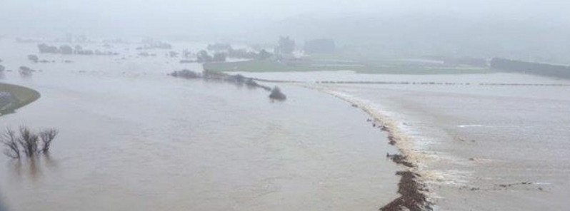
Featured image: Widespread flooding hits Taieri Plain, South Island, New Zealand - July 22, 2017. Credit: Grant Vickers
A powerful storm system dumped very heavy rain on New Zealand's South Island on Friday, July 21, 2017 into July 22, causing widespread flooding. By 08:00 UTC today, 4 areas declared states of emergency – Christchurch, Dunedin, Timaru and Otago. Weather stations in some areas recorded more than 220 mm (8.7 inches) of rain within 24 hours, more than twice the July average. The very deep low which brought this heavy rain and strong winds across much of New Zealand moved east of the North Island by late Saturday (local time), and should continue moving away to the east into Sunday. Another front is expected to start affecting the country on Monday, followed by yet another on Wednesday, July 26.
Christchurch declared a state of emergency Saturday morning, July 22, 2017, after Heathcote River burst its banks Friday, thus becoming the fourth area to do so within 24 hours as a powerful storm marched through the region.
According to The Sydney Morning Herald, about 1 500 people in settlements north of Christchurch were told to leave their homes after water levels rose overnight, while more than 100 homes were evacuated outside Dunedin. Emergency services are now focused on the Taieri River near Dunedin after predictions it would rise to near-record levels on Saturday.
The weather bureau said rivers in affected areas remained at very high levels on Saturday morning after some areas were hit with more than 200 mm (7.9 inches) of rain in 24 hours – more than twice the July average. More than 220 mm (8.7 inches) of rain was recorded on the hills north of Dunedin, 162 mm (6.4 inches) in Oamaru and 104 mm (4 inches) in Ashburton.
The state of emergency in Timaru area has been lifted around noon Saturday, and residents have started a big cleanup after the second largest flood of the Taieri River on record.
At around the same time, the rain has begun to ease in Dunedin, but the state of emergency for the city continues. "We are dealing with a very severe rainfall event," said civil affairs minister Nathan Guy, who flew to Dunedin on Saturday to assist local authorities.
Dunedin Civil Defence controller David Campbell said the main areas of concern were the Taieri River, which remains high, slips and other widespread issues throughout the roading network. Civil Defence has evacuated several rural properties in the Mill Creek area, Taieri because of concerns about the structure of the pump station due to high river flows, NZ Herald reports. There are approximately 26 slips on roads across the city, including on Ravenswood St in St Clair which has been closed and where 12 houses have been evacuated due to a slip.
Another 30 to 50 mm (1.2 – 2 inches) of rain was expected to fall on south-eastern parts of the South Island on Saturday, according to the MetService, while heavy snowfall is expected in Central Otago.
The New Zealand Transport Authority was asking people to avoid all non-essential travel and stay home. Prime Minister Bill English called residents to follow official advice and take care of each other.
According to MetService, a front is forecast to move up the South Island on Monday, then to weaken as it crosses the North Island overnight Monday. This system will bring a period of heavy rain to western regions of the South Island, with moderate confidence of rainfall amounts reaching warning criteria in Fiordland and Westland, while the confidence is low in Buller.
The front is forecast to move to the east of the country by Tuesday, and is followed by westerly flow.
A second active front is forecast move up the South Island during Wednesday and Thursday, bringing another period of heavy rain into western regions of the island. There is moderate confidence that rainfall accumulations will reach warning criteria in Fiordland and southern Westland on Wednesday, while on Thursday there is moderate confidence for northern Westland and low confidence for Buller.
In addition, this front is expected to bring a cold southerly change into eastern regions of the South Island on Thursday from Southland through to Canterbury. Snow is forecast to lower down to about 200 to 300 m (650 – 980 feet) with the passage of the front, and possibly lower in the far south, but warning amounts of snow are not expected at this stage.
I'm a dedicated researcher, journalist, and editor at The Watchers. With over 20 years of experience in the media industry, I specialize in hard science news, focusing on extreme weather, seismic and volcanic activity, space weather, and astronomy, including near-Earth objects and planetary defense strategies. You can reach me at teo /at/ watchers.news.
Commenting rules and guidelines
We value the thoughts and opinions of our readers and welcome healthy discussions on our website. In order to maintain a respectful and positive community, we ask that all commenters follow these rules.