
Large gustnado near Exeter, Nebraska
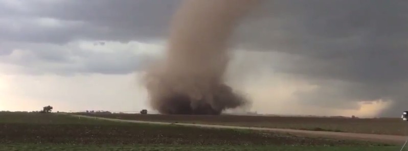
Featured image: Landspout (gustnado) near Exeter, Nebraska on May 16, 2017. Credit: Jerry Boeck
A large gustnado or landspout was spotted and recorded near Exeter, Nebraska on May 16, 2017. The event was followed by rain and pea-sized hail soon after.
Although there were no damage or injuries reported, the sight evoked horrible memories to Jerry and Theresa Boeck who recorded the event. Three years ago, they lost part of their business to the 2014 Mother's Day tornadoes in southeast Nebraska, the couple told 10/11 News. "I was just moments from getting my family and customers into the storm shelter," Jerry said.
Northeast of Exeter…followed by rain and pea-sized hail. @LukeDorrisKLKN @NWSHastings #NEwx pic.twitter.com/Duqim9n0es
— Boeck Seed Services (@BoeckSeed) May 16, 2017
A landspout, also known as gustnado, is a term coined by meteorologist Howard B. Bluestein in 1985 for a kind of tornado not associated with the mesocyclone of a thunderstorm.
It is a colloquial expression describing tornadoes occurring with a parent cloud in its growth stage and with its vorticity originating in the boundary layer. The parent cloud does not contain a preexisting midlevel mesocyclone. The landspout was so named because it looks like "a weak Florida Keys waterspout over land."
Landspouts can extend anywhere from 9 to 90 m (30 to 300 feet) above the surface and usually last a few seconds to a few minutes. They may have wind speeds of 96 – 129 km/h (60 to 80 mph) and may cause damage equivalent to an EF-0 or EF-1 tornado.
There are reports of landspouts that lasted for more than 15 minutes and those that produced an EF-3 tornado equivalent damage. However, most of them rarely produce damage.

Teo Blašković founded The Watchers in 2011 and edited it until 2026, covering seismic and volcanic activity, extreme weather, space weather and near-Earth objects. Articles on this page are his archive.
Published in the last 24 hours
- The storms drenching California this week are fed by a river in the sky, a band of water vapor that can carry up to 15 times the flow of the Mississippi River, and this winter’s near-record El Niño could keep aiming more of them at the West Coast
- Malawi continues Bris AI weather forecasting tests ahead of operational integration Epicenter
- Right about now, Voyager 1 is crossing a line no human-made object has ever reached, a full light-day from Earth, which means a message NASA sends tonight won't arrive until tomorrow night, and the spacecraft's answer won't make it home until the night after that
- G1 geomagnetic storm watch remains in effect as NOAA forecasts Kp 4.67 late on November 17 and early on November 18
