
Possible eruption of Cerro Azul in the next few days to weeks
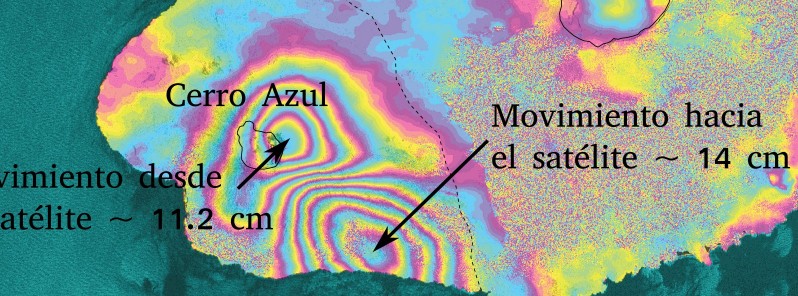
Featured image: Cerro Azul radar interferogram between March 8 and 20, 2017. Credit: ESA/Sentinel-1 processed by Marco Bagnardi, Comet, University of Leeds
Seismic and deformation data indicate magma is trying to rise to the surface at Cerro Azul volcano in Galapagos, Ecuador. An eruption can be expected in the next few days or weeks, probably of the same type as those previously occurring at the volcano – the emission of lava flows, IGEPN said in a special report released March 24, 2017.
Seismic activity in the vicinity of Sierra Negra volcano started increasing on February 15, 2017 and between March 18 and 19 migrated south, concentrating southeast of the Cerro Azul volcano.
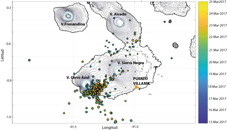
Cerro Azul earthquakes between March 13 and 25, 2017. Credit: IGEPN
On March 21, between 19:15 and 22:00 local time, a new swarm occurred under the volcano. Most events had magnitudes between 2.4 and 3.6. After this episode, the seismicity continued but earthquakes were more dispersed.
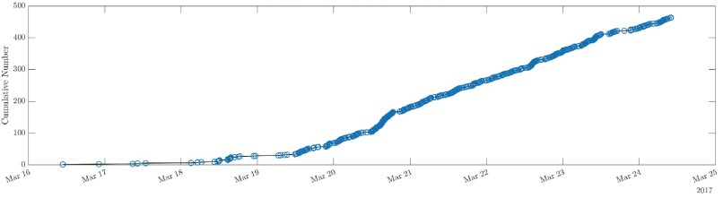
The number of daily earthquakes under Cerro Azul volcano between March 20 and 21, 2017. Credit: IGEPN
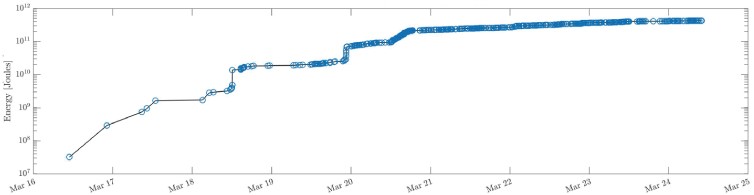
Energy released in Cerro Azul region from March 16, 2017. Credit: IGEPN
A clear deformation of the Cerro Azul volcano was observed between March 8 and 20, 2017 on Sentinel-1 radar interferogram. The deformation is characterized by an inflation of the southeastern flank of the volcano of approximately 14 cm (5.5 inches) and associated with a summit deflation of approximately 11.2 cm (4.4 inches).
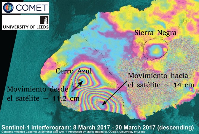
Cerro Azul radar interferogram between March 8 and 20, 2017. Credit: ESA/Sentinel-1 processed by Marco Bagnardi, Comet, University of Leeds
"These data reproduce very well in the numerical model, corresponding to a volume of 20 to 40 million m3 of magma that left the reservoir 5.5 to 7 km (3.4 – 4.3 miles) below the summit and that feeds an intrusion in the form of sill located between 3.5 and 6.3 km (2.1 and 3.9 miles) under the southeastern flank," IGEPN said.
There is a possibility that a new eruption of Cerro Azul will take place in the next few days to weeks. However, it is also possible that observed activity will decay without magma reaching the surface.
The Cerro Azul eruption in 2008
The last known eruption of this volcano started on May 29, 2008 after an increase in seismic activity. The eruptive episode lasted until June 11 with two distinguished eruptive phases.
The first phase, which occurred between May 29 and June 1, consisted of a rapid emission of lava flows from the top of the cone along concentric and radial fractures. This activity generated a low ash eruptive column that drifted to the NW. Some lava flows emitted from the summit entered the caldera of the volcano. During this phase, the highest magnitude earthquake (3.7, May 30) was located in the northern part of the volcano with a SO2 emission of 10 597 kt. The largest SO2emission was observed by the IMO instrument on May 31 with 21 820 kt.
In contrast, during the second eruptive phase the lava flows were emitted from a radial fissure in the lower part of the building. These flows descended up to 10 km (6.2 miles) along the SE and E flanks of the volcano with an average width of 2 – 3 km (1.2 – 1.8 miles). Eruptive activity declined sharply between June 16 and 17.
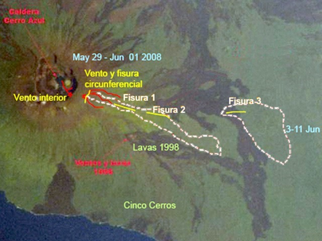
Lava flows emitted during the eruption of Cerro Azul volcano in 2008. Credit: IG
Geological summary
Located at the SW tip of the J-shaped Isabela Island, Cerro Azul contains a steep-walled 4 x 5 km nested summit caldera complex that is one of the smallest diameter, but at 650 m one of the deepest in the Galápagos Islands. The 1640-m-high shield volcano is the second highest of the archipelago. A conspicuous bench occupies the SW and west sides of the caldera, which formed during several episodes of collapse. Youthful lava flows cover much of the caldera floor, which has also contained ephemeral lakes. A prominent tuff cone located at the ENE side of the caldera is evidence of episodic hydrovolcanism.
Numerous spatter cones dot the western flanks. Fresh-looking lava flows, many erupted from circumferential fissures, descend the NE and NW flanks. Historical eruptions date back only to 1932, but Cerro Azul has been one of the most active Galápagos volcanoes since that time. Solfataric activity continues within the caldera. (GVP)
I'm a dedicated researcher, journalist, and editor at The Watchers. With over 20 years of experience in the media industry, I specialize in hard science news, focusing on extreme weather, seismic and volcanic activity, space weather, and astronomy, including near-Earth objects and planetary defense strategies. You can reach me at teo /at/ watchers.news.
I like this pages.