
Rapidly intensifying storm hits Ireland and UK
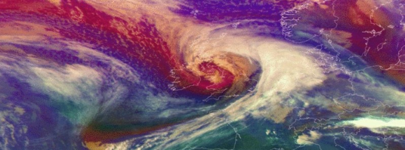
Featured image: Rapidly intensifying Storm Doris over Ireland and the United Kingdom on February 23, 2017. Credit: EUMETSAT/SEVIRI
Storm Doris rapidly intensified as it moved over Ireland and the United Kingdom Thursday morning, February 23, 2017, bringing powerful winds, heavy rain and snow. As of late afternoon, at least one person has been killed.
Doris tracked across Ireland and the United Kingdom with wind gusts up to 151 km/h (94 mph), downing trees and power lines and cutting power to over 23 000 customers across Northern Ireland. By 17:00 UTC, power was restored to 21 500 customers. Officials said the main cause of damage to UK's power grid were trees and branches falling onto overhead electricity lines.
The strongest winds were reported in Wales, where one woman died when she was hit by debris falling into the street in the Midlands city of Wolverhampton. Heavy snow in Scotland forced school closures.
A number of Amber and Yellow National Severe Weather Warning warnings are in place across the UK for snow, rain, wind and ice.
In the Republic of Ireland, Doris cut off power to about 56 000 customers, most of it in counties Galway, Mayo, Sligo, Leitrim and Dublin.
Video courtesy UK Met Office
The storm caused serious road and rail traffic disruption and delayed numerous flights and ferries.
“Apart from the fact that some places over southern Scotland have had less snow than expected, storm Doris is behaving itself. It has undergone explosive cyclogenesis, and is giving damaging winds across parts of England and Wales,” UK Met Office's Chief Meteorologist Eddy Carroll said.
"As it moves eastwards over the North Sea later today the winds and snow will ease, but ice could be a hazard over parts of the north overnight.”
View #StormDoris from space with this satellite image showing her moving eastwards across the UK pic.twitter.com/Oa3ELPaMBj
— Met Office (@metoffice) February 23, 2017
satellite loop (SEVIRI RGB Airmass) highlighting intense storm force low lashing Ireland, the UK, and now pushing into the North Sea pic.twitter.com/BjZVOubp0K
— NWS OPC (@NWSOPC) February 23, 2017
Member @PaulKingstonNNP reports knee deep sea foam earlier in Cleveleys, UK #Stormhour #StormDoris 25/30 #eustorm pic.twitter.com/I5NNk0WieG
— #eustorm (@EUStormMap) February 23, 2017
The "Lesser Used Trampoline" on its annual migration from Pwllheli to Fflint today. #stormdoris pic.twitter.com/LIqeia2OYz
— Welsh Bollocks (@welshbollocks) February 23, 2017
Here are some of the strongest gusts we have seen so far today from #StormDoris pic.twitter.com/SzkoRG0pH3
— Met Office (@metoffice) February 23, 2017
Friday will bring a welcome break from the unsettled conditions with some sunny spells for many and much calmer winds after a cold start with a risk of icy patches.
“Saturday, however, will see further strong winds and another spell of wet weather, particularly over the northwest of the UK where the rain is likely to be locally heavy and persistent,” deputy Chief Meteorologist Dan Harris added.
The storm is now moving further east into Europe.
What is a weather bomb
Video courtesy UK Met Office
The Watchers team and our contributors bring the latest on extreme weather, earthquakes, volcanic eruptions, space weather, and all things science. We're all about making sense of the natural world and keeping you informed on what’s happening. Got a tip or a question? Hit us up using the form at newstips!
Commenting rules and guidelines
We value the thoughts and opinions of our readers and welcome healthy discussions on our website. In order to maintain a respectful and positive community, we ask that all commenters follow these rules.