
Scientists identify a new continent and name it Zealandia

Image credit: Mortimer et al. / GSA
Scientists have identified a new continent in the southwest Pacific Ocean recently, formerly a part of Gondwana, and named it Zealandia. Basically, from a well-reasoned geoscience perspective, Earth has well-established continents, but also an extra one, mostly underwater.
A new paper published by the Geological Society of America states that several islands, notably New Zealand and New Caledonia, are connected by submerged continental crust across a large area of Earth's surface and that this mostly underwater continent is geologically separate and distinct from Australia and Antarctica.
"This is not a sudden discovery but a gradual realization. As recently as 10 years ago we would not have had the accumulated data or confidence in interpretation to write this paper," the authors say.
This region of the southwest Pacific Ocean is as large as 4.9 km2 (1.9 million mi2). It has elevated bathymetry relative to surrounding oceanic crust, diverse and silica-rich rocks, and relatively thick and low-velocity crustal structure. Its isolation from Australia and large area support its definition as a continent.
Zealandia was formerly part of Gondwana, but today it is 94% submerged, mainly as a result of widespread Late Cretaceous crustal thinning preceding supercontinent breakup and consequent isostatic balance.
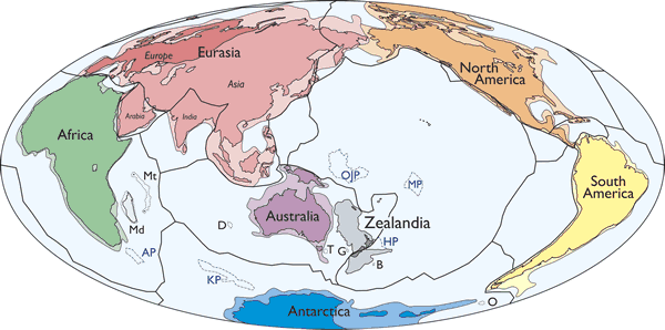
Simplified map of Earth’s tectonic plates and continents, including Zealandia. Continental shelf areas shown in pale colors. Large igneous province (LIP) submarine plateaus shown by blue dashed lines: AP—Agulhas Plateau; KP—Kerguelen Plateau; OJP—Ontong Java Plateau; MP—Manihiki Plateau; HP—Hikurangi Plateau. Selected microcontinents and continental fragments shown by black dotted lines: Md—Madagascar; Mt—Mauritia; D—Gulden Draak; T—East Tasman; G—Gilbert; B—Bollons; O—South Orkney. Hammer equal area projection. Credit: Mortimer et al. / GSA
Satellite gravity-derived bathymetry maps have been of immense use in visualizing Zealandia, clarifying its limits, focusing attention on intra-Zealandia structures, and planning research voyages.
If the elevation of Earth’s solid surface had first been mapped in the same way as those of Mars and Venus (which lack the arbitrary datums of opaque liquid oceans), authors say that Zealandia would have been investigated and identified as one of Earth’s continents much earlier.
They see Zealandia as a coherent, albeit thinned and stretched, continent with interconnected and through going geological provinces. Like parts of North America and Eurasia, Zealandia has undergone active deformation in a zone between two essentially rigid plates—in Zealandia’s case, the Pacific and Australian.
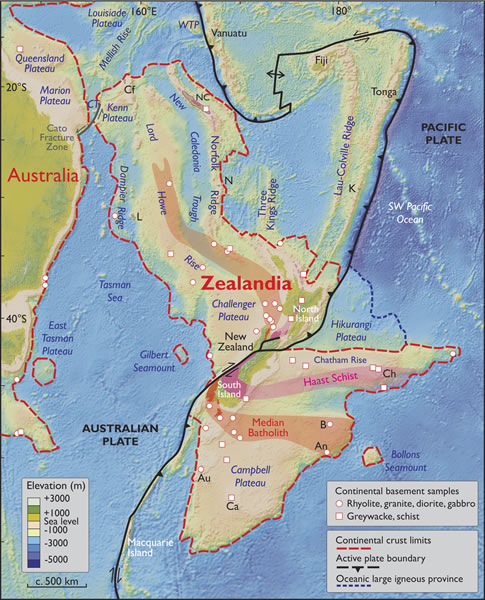
Spatial limits of Zealandia. Base map from Stagpoole (2002) based on data from Smith and Sandwell (1997). Continental basement samples from Suggate et al. (1978), Beggs et al. (1990), Tulloch et al. (1991, 2009), Gamble et al. (1993), McDougall et al. (1994), and Mortimer et al. (1997, 1998, 2006, 2008a, 2008b, 2015). NC—New Caledonia; WTP—West Torres Plateau; CT—Cato Trough; Cf—Chesterfield Islands; L—Lord Howe Island; N—Norfolk Island; K—Kermadec Islands; Ch—Chatham Islands; B—Bounty Islands; An—Antipodes Islands; Au—Auckland Islands; Ca—Campbell Island. Mercator projection. Credit: Mortimer et al. / GSA
"Zealandia once made up ~5% of the area of Gondwana. It contains the principal geological record of the Mesozoic convergent margin of southeast Gondwana and, until the Late Cretaceous, lay Pacificward of half of West Antarctica and all of eastern Australia. Thus, depictions of the Paleozoic-Mesozoic geology of Gondwana, eastern Australia, and West Antarctica are both incomplete and misleading if they omit Zealandia," they write.
The importance of Zealandia is not so much that there is now a case for a formerly little-known continent, but that, by virtue of its being thinned and submerged, but not shredded into microcontinents, it is a new and useful continental end member. Zealandia started to separate from Gondwana in the Late Cretaceous as an ~4 000-km-long (2 500 miles) ribbon continent but has since undergone substantial intracontinental deformation, to end up in its present shape and position.
As well as being the seventh largest geological continent, Zealandia is the youngest, thinnest, and most submerged. The scientific value of classifying Zealandia as a continent is much more than just an extra name on a list. That a continent can be so submerged yet unfragmented makes it a useful and thought-provoking geodynamic end member in exploring the cohesion and breakup of continental crust.
Reference:
- "Zealandia: Earth’s Hidden Continent" – Nick Mortimer, Hamish J. Campbell, Andy J. Tulloch, Peter R. King, Vaughan M. Stagpoole, Ray A. Wood, Mark S. Rattenbury, Rupert Sutherland, Chris J. Adams, Julien Collot, Maria Seton – The Geological Society of America (2017) – doi: 10.1130/GSATG321A.1
The Watchers team and our contributors bring the latest on extreme weather, earthquakes, volcanic eruptions, space weather, and all things science. We're all about making sense of the natural world and keeping you informed on what’s happening. Got a tip or a question? Hit us up using the form at newstips!
Commenting rules and guidelines
We value the thoughts and opinions of our readers and welcome healthy discussions on our website. In order to maintain a respectful and positive community, we ask that all commenters follow these rules.