
Powerful winter storm aims US Northeast and Canada
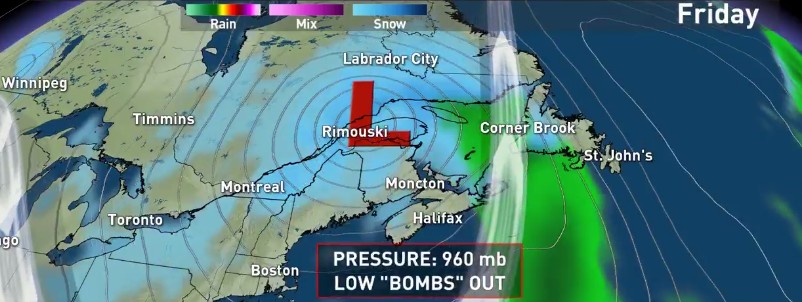
Image credit: The Weather Network
A powerful, fast-moving winter storm is expected to bring significant snowfall, rain and strong winds to portions of the US Northeast and Atlantic Canada on Thursday and Friday, December 29 and 30, 2016. The storm is expected to undergo a rapid strengthening within a period of only 24 hours.
A surface low moving through the Eastern United States will rapidly deepen as it exists the Mid-Atlantic and moves up the Northeast coast on Thursday, NWS warns.
Heavy snowfall will begin by Thursday afternoon (local time) and continue into Friday with storm total accumulations of a foot or more possible for places from the Adirondacks to western Maine, US.
In addition to the heavy snowfall, gusty winds will also accompany the storm making travel across much of the region hazardous and difficult.
On the backside of the system, cold air and favorable flow over the Great Lakes should be enough to produce lake enhanced heavy snowfall downwind of lakes Erie and Ontario through at least Friday with accumulating snow also expected along favorable upslope regions of the central Appalachians.
Weather.com named the storm Fortis and warned that the low is expected to undergo "bombogenesis," a rapid strengthening within a period of only 24 hours, Thursday night into Friday. As a result, about a 12- to 18-hour period of heavy snow and strong winds is expected over much of New England.
Winter storm warnings have been posted from western Massachusetts to Maine, over areas likely to see the heaviest snow. A winter storm warning is also in effect in the highest mountains of eastern West Virginia.
Lake-effect snow watches, warnings and advisories cover parts of central and western New York, northwest Pennsylvania, northeast Ohio, the Upper Peninsula of Michigan and far northern Wisconsin.
On the other side of the border, this major system is expected to 'bomb out' as it tracks across Atlantic Canada, bringing damaging winds, heavy snow and rain to the region through Friday, The Weather Network reported.
A swath of weather alerts are in effect for Nova Scotia, New Brunswick, Prince Edward Island, and Newfoundland ahead of the low. Nova Scotia and P.E.I. remain under a wind warning, and most of New Brunswick is under a snowfall warning. Much of Newfoundland is under a special weather statement.
"A deepening upper level trough in the jet stream over Central Canada will cause the rapid intensification of a low pressure system off the New Jersey shores, allowing the system to bomb out (possibly 30-40 mb drop in pressure over 24 hours – forecast low pressure: 960 mb)," said The Weather Network meteorologist Erin Wenckstern. "The low will be fast-moving, so it will drop a significant amount of snow or rain in a quick period of time as it tracks across New Brunswick Friday morning into Labrador by the evening."
Powerful wind gusts of up to 130 km/h (80.7 mph) are possible with this system for coastal sections, with scattered power outages likely across the region.
"If you live in the Maritimes, particularly New Brunswick, expect a slow or difficult commute Friday morning," Wenckstern added.
The Watchers team and our contributors bring the latest on extreme weather, earthquakes, volcanic eruptions, space weather, and all things science. We're all about making sense of the natural world and keeping you informed on what’s happening. Got a tip or a question? Hit us up using the form at newstips!
Must be Global Warming…