
Scientists create 3-D view of ancient flood channels beneath Martian surface

Image credit: Bruce Irving - CC BY 2.0
While Curiosity is drilling Martian rocks, NASA’s Mars reconnaissance orbiter is continuing its observations to demystify the Red planet. Recently, scientists created 3-D reconstruction of ancient water channels beneath martian surface using images taken by the orbiter, NASA reported on March 7. These images show flood channels created by catastrophic flooding in the last 500 million years – era during which Mars was thought to have been cold and dry.
These images will help understanding the extent to which recent hydrologic activity prevailed during such arid conditions and determine whether the floods could have induced episodes of climate change. Gareth Morgan, a geologist at the National Air and Space Museum’s Center for Earth and Planetary Studies in Washington and lead author on the paper said,
“Our findings show the scale of erosion that created the channels previously was underestimated and the channel depth was at least twice that of previous approximations. This work demonstrates the importance of orbital sounding radar in understanding how water has shaped the surface of Mars.”
Dubbed as Marte Vallis channel system, these channels lie in Elysium Planitia, an expanse of plains along the Martian equator and the youngest volcanic region on the planet. Extensive volcanism throughout the last several hundred million years covered most of the surface of Elysium Planitia, and this buried evidence of Mars’ older geologic history, including the source and most of the length of the 620-mile-long (1000-kilometer-long) Marte Vallis channel system.
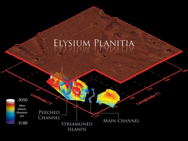 This illustration schematically shows where the Shallow Radar instrument on NASA’s Mars Reconnaissance Orbiter detected flood channels that had been buried by lava flows in the Elysium Planitia region of Mars. Marte Vallis consists of multiple perched channels formed around streamlined islands. These channels feed a deeper and wider main channel.
Image Credit: NASA/JPL-Caltech/Sapienza University of Rome/Smithsonian Institution/USGS
Researchers used the Mars Reconnaissance Orbiter’s Shallow Radar (SHARAD) to probe the length, width and depth of these underground channels. Marte Vallis’ morphology is similar to more ancient channel systems on Mars, especially those of the Chryse basin. Many scientists think the Chryse channels likely were formed by the catastrophic release of ground water, although others suggest lava can produce many of the same features. In comparison, little is known about Marte Vallis.
With the SHARAD radar, the team was able to map the buried channels in three dimensions with enough detail to see evidence suggesting two different phases of channel formation. One phase etched a series of smaller branching, or “anastomosing,” channels that are now on a raised “bench” next to the main channel. These smaller channels flowed around four streamlined islands. A second phase carved the deep, wide channels. Lynn Carter, the paper’s co-author from NASA’s Goddard Space Flight Center in Greenbelt, Md. said,
“In this region, the radar picked up multiple ‘reflectors,’ which are surfaces or boundaries that reflect radio waves, so it was possible to see multiple layers. We have rarely seen that in SHARAD data outside of the polar ice regions of Mars.”
The mapping also provided sufficient information to establish the floods that carved the channels originated from a now-buried portion of the Cerberus Fossae fracture system. The water could have accumulated in an underground reservoir and been released by tectonic or volcanic activity.
Source: NASA
Commenting rules and guidelines
We value the thoughts and opinions of our readers and welcome healthy discussions on our website. In order to maintain a respectful and positive community, we ask that all commenters follow these rules.