
Magnitude 6.9 – Near the coast of central Peru
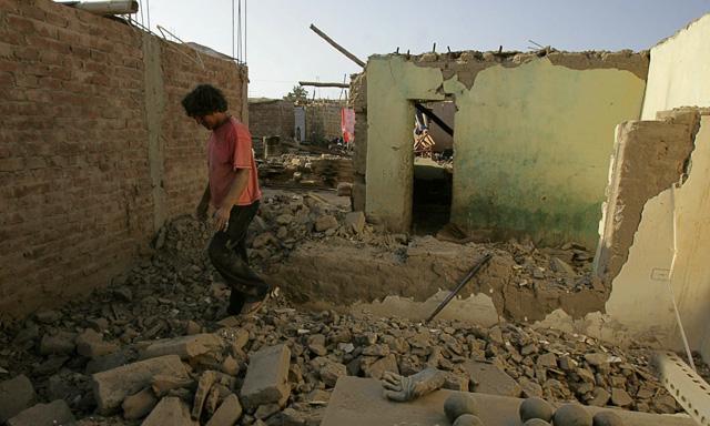
Image credit: TW
According to USGS, magnitude 6.9 earthquake struck near the coast of central Peru at 18:54:33 UTC; 51 km (31 miles) SSW of Ica, 112 km (69 miles) S of Chincha Alta, 201 km (124 miles) W of Puquio and 288 km (178 miles) SSE of LIMA, Peru (14.515°S, 76.009°W) at depth of 23.9 km (14.9 miles). EMSC registered magnitude 7.0 earthquake at depth of 27km. Peruvian IGP registered 6-7 magnitude at depth of 14km.


USGS PAGER issued YELLOW ALERT. Yellow alert level for shaking-related fatalities. Some casualties are possible and the impact should be relatively localized. Past events with this alert level have required a local or regional level response. Green alert level for economic losses. There is a low likelihood of damage.
Peru’s RPP radio reported that people in cities along the southern coast ran out of their homes and into the streets during the quake, but said damages were limited to loss of cell phone signals and isolated electricity outages in Ica.
Southern Copper, a major global mining firm, said its operations were normal and not impacted by the earthquake. Most other major mines in Peru, a leading global metals exporter, are located farther away from the quake zone. (GMA)


Yellow alert level for shaking-related fatalities. Some casualties are possible and the impact should be relatively localized. Past events with this alert level have required a local or regional level response. Green alert level for economic losses. There is a low likelihood of damage.
The Peru-Chile Trench, also known as the Atacama Trench, is an oceanic trench in the eastern Pacific Ocean, about 160 kilometres (100 mi) off the coast of Peru and Chile. It reaches a maximum depth of 8,065 metres (26,460 ft) below sea level in Richards Deep and is approximately 5,900 kilometres (3,666 mi) long; its mean width is 64 kilometres (40 mi) and it covers an expanse of some 590,000 square kilometres (228,000 mi²).
The trench is a result of the eastern edge of the Nazca Plate being subducted under the South American Plate. The trench subducts two seamount ridges; the Nazca Ridge and the Juan Fernández Ridge.
The Peru-Chile Trench, the forearc and the western edge of the central Andean plateau (Altiplano), delineate the dramatic “Bolivian Orocline” that defines the Andean slope of southern Peru, northern Chile, and Bolivia. From the Chile Triple Junction to Juan Fernández Ridge the trench is filled with 2.0 to 2.5 km of mainly turbidite sediments, creating thus a flat bottom topography. (Wikipedia)
Regional Center for Seismology for South America: CERESIS
UPDATE:
Seismologist Julio Kuroiwa in saying that very strong earthquake could be called an “aftershock ” of the massive 2007 earthquake. Massive earthquakes can trigger very strong to massive aftershocks for decades. Mr. Koraiwa compared both the 2007 earthquake with aftershock, as he called it. The 2007 7.9 magnitude earthquake was 30 times stronger than the one from Friday.
The video below from 24Horas a Peruvian TV station is showing emotional scenes and a lot of chaos in Ica. Luckily not too much damage, but as you will see People were panicking a lot.
The Peruvian Civil Defense, responsible for organizing the rescue and relief support to the people have reported that at least 83 people were injured by this earthquake. 132 houses have been reported collapsed and many more damaged.
The people living at the coastal town of Pisco have been seriously alarmed by a fast retiring Ocean. Retiring oceans can be a signal for an upcoming tsunami.
The Theoretical models of GDACS using an epicenter close to the coast are returning very damaging tsunami waves up to 4.8 meter high (this is VERY high for tsunami waves). So far we have NO news from these coastal localities. We remind our readers that theoretical models are based on historical information and on information from seismological agencies. GDACS has used the USGS data for their computing. Acording to the peruvian newspaper LA REPUBLICA, the earthquake was also felt in Northern Chile.

IGP, Peru is giving the following (little weaker) data for this earthquake : Depth : 30 km, Magnitude 6.7 and very good news for Ica : 117 km South East of Ica. The IGP data are completely different than those from USGS. The distance to the major city of Ica is almost double. Local seismological agencies are often very close to the real epicenter because their instruments are mostly closest to the epicenter.
The epicenter following IGP is at least 50 km out of the coast and is right in the middle of the subduction slope. This very steep subducting hang has a height of 3,000 meter!. Hopefully, NO sea-slides will occur on this steep mountain. All this means that the THINLY POPULATED COASTAL AREA IS AT HIGH RISK for the strong shaking and an eventual tsunami. Earthquakes below 7.0 are seldom generating tsunamis. (EarthquakeReport)
Commenting rules and guidelines
We value the thoughts and opinions of our readers and welcome healthy discussions on our website. In order to maintain a respectful and positive community, we ask that all commenters follow these rules.