
San Juan River cuts through 300-million-year-old rocks while retaining its winding course in Utah
At Utah’s Goosenecks, the San Juan River winds through a canyon about 300 m (1 000 feet) deep, yet its tight bends were established before the gorge was carved. An astronaut photograph published by NASA on November 6, 2026, shows the result of a long geological process in which the river retained its winding course as uplift of the Colorado Plateau helped drive deeper erosion into ancient rock.
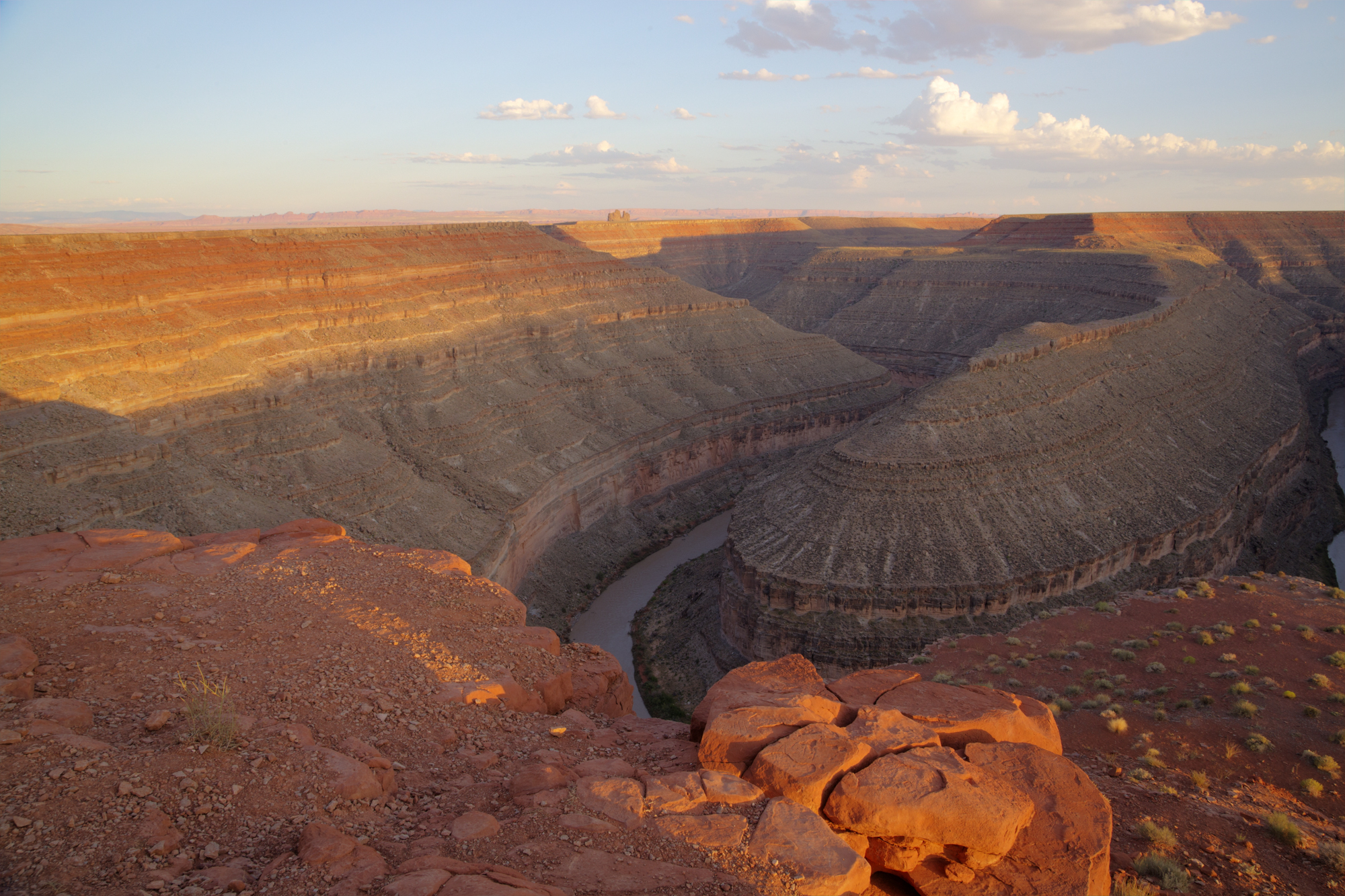
Sunlight illuminates the layered canyon walls at Goosenecks State Park on August 8, 2016. Erosion has exposed thick sequences of sedimentary rock along the San Juan River. Credit: Bob Wick / Bureau of Land Management
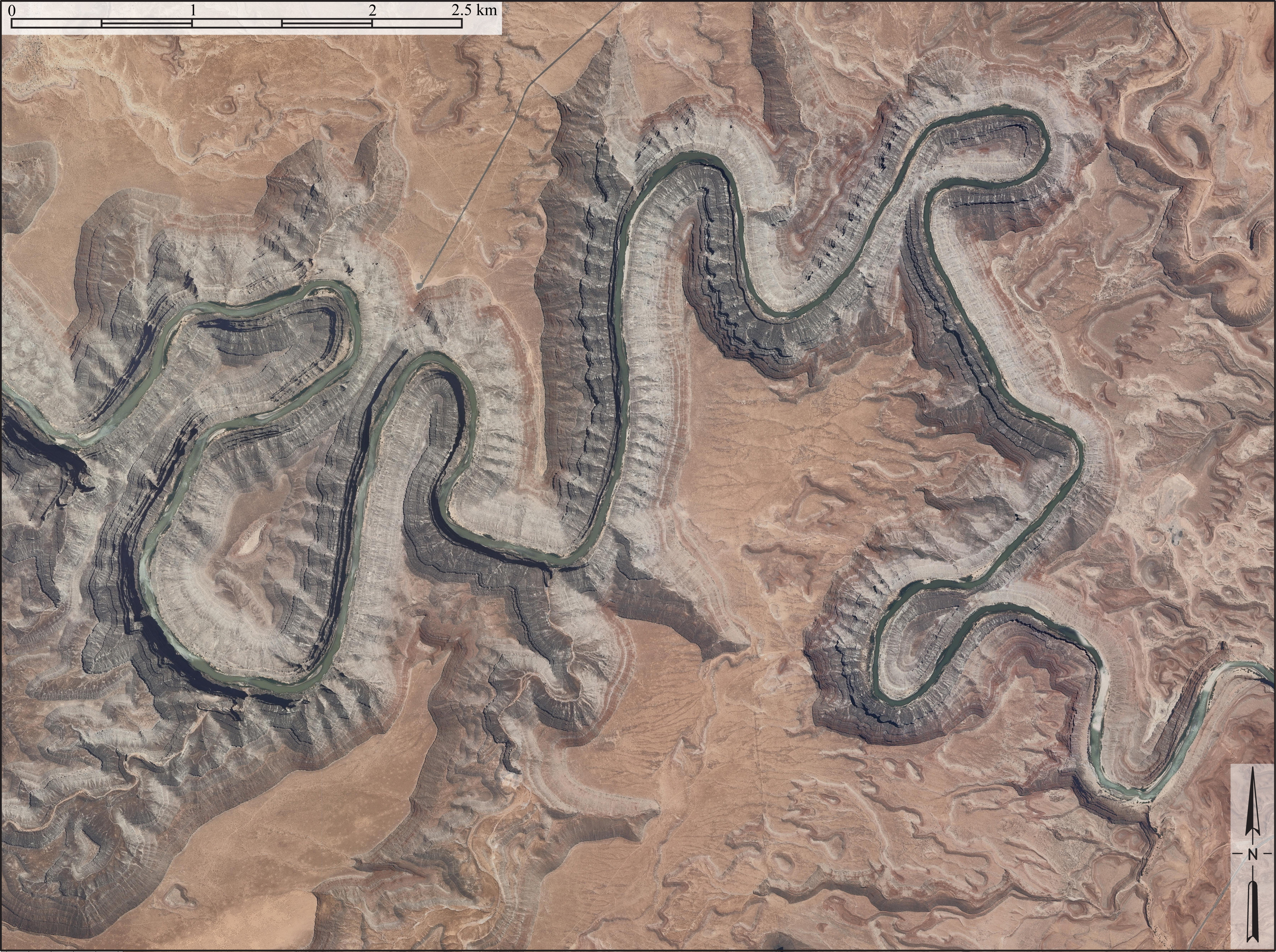
NASA Earth Observatory published the astronaut view on November 6, 2026, one month after it was acquired by a member of the International Space Station’s Expedition 75 crew on October 6. The image shows the San Juan River crossing southern Utah in a succession of sharply curved canyons. In one section of the Goosenecks, the river travels 8.9 km (5.5 miles) along its channel between points separated by only 2.1 km (1.3 miles) in a straight line.

The tightly curved channel is an example of an entrenched meander, a river bend preserved as the channel cuts downward into bedrock. The significance lies in the combination of two processes that ordinarily develop under different landscape conditions. Broad river bends tend to form where gradients are gentle enough for channels to migrate sideways. Deep canyon incision is more closely associated with conditions that promote vertical erosion. The Goosenecks preserve a winding river pattern within a deeply incised canyon.
The aerial geometry makes the relationship especially clear. Narrow ridges separate adjacent reaches of the river, but the channel follows the full length of each loop rather than crossing directly over those ridges. The river’s route is therefore much longer than the straight-line distance across the same part of the landscape. From above, the meanders also expose the contrast between the relatively broad plateau surface and the much narrower canyon occupied by the river.
The Utah Geological Survey reconstructs an earlier landscape in which the ancestral San Juan flowed across comparatively gentle terrain. Meandering channels can shift laterally through erosion along their outer banks and deposition along their inner banks. Over time, that movement produces broad curves and looping channels. According to the survey, the San Juan had already established its winding route before the later phase of accelerated downcutting formed the present canyon.
That earlier course became important as regional elevation changed. Uplift associated with the Colorado Plateau increased the river’s gradient, the amount of elevation lost along a given distance of channel. A greater gradient can increase the energy available for erosion, allowing water and transported sediment to cut more effectively into the riverbed. At the Goosenecks, downward erosion became sufficiently important that much of the inherited winding pattern was retained as the river incised into the underlying rock.

The contour lines show how sharply the landscape descends toward the channel. Closely spaced contours indicate steep slopes, while wider spacing indicates gentler terrain. Around the Goosenecks, these contours follow the same looping geometry as the river, reflecting the depth of the canyon cut into the plateau. The pattern also helps explain why the feature is described as entrenched rather than simply meandering across a floodplain.

The canyon walls provide a separate record of the region’s geological history. The Utah Geological Survey identifies the Paradox Formation in the lower cliffs and the Honaker Trail Formation above it. These formations consist of sedimentary rocks more than 300 million years old, including limestone, siltstone, sandstone and shale. Their layers record conditions in an ancient marine environment where changes in sea level repeatedly altered the sediments being deposited.
The Halgaito Formation overlies the Honaker Trail Formation and extends across parts of the surrounding desert surface, according to the Utah Geological Survey. The rock sequence therefore records a much older environmental history than the river incision responsible for the modern canyon. The approximately 300-million-year age of the exposed rocks should not be confused with the age of the Goosenecks themselves. The rocks formed long before the river carved its present deeply entrenched course.
The survey places an important later stage of regional uplift approximately 15–20 million years ago, while acknowledging continuing debate over its timing. NASA gives a similar qualified explanation, describing interpretations in which uplift beginning around 20 million years ago raised the San Juan’s headwaters, increased the channel gradient and accelerated erosion. The dates refer to a proposed phase of regional tectonic and drainage development, not a direct measurement of the age of individual river bends.

A 2022 scientific review by Karl Karlstrom and colleagues places the uplift of the Colorado Plateau within a longer, multi-stage tectonic history. The researchers identify three broad episodes of uplift: approximately 70–50 million years ago, 38–23 million years ago and a younger phase beginning less than 20 million years ago. Those intervals describe the evolution of the wider plateau rather than three separately dated stages in the formation of the Goosenecks.
The review associates the earlier episodes with processes including the interaction of tectonic plates beneath western North America and regional magmatism. Its interpretation of the youngest phase involves basaltic magmatism advancing inward from the plateau margins and the erosion of the lithospheric core by mantle processes. The lithosphere is the comparatively rigid outer layer of Earth, including the crust and uppermost mantle. Changes beneath it can contribute to the elevation and deformation of the overlying landscape over geological time.
This broader history complicates attempts to assign the formation of the San Juan canyon to one precisely dated uplift event. River incision responds not only to changes in regional elevation but also to the development of connected drainage systems and the movement of sediment through them. The observable Goosenecks establish that deep incision followed the formation of a strongly winding channel, while the timing and tectonic mechanisms of plateau uplift must be investigated through additional geological evidence.

The 2026 astronaut photograph adds a recent orbital observation to this established geological interpretation. NASA identifies the image as ISS075-E-188830, acquired with a Nikon Z9 digital camera and a focal length of 400 mm. The photograph was taken through the ISS Crew Earth Observations program, which documents terrestrial landscapes and environmental conditions from orbit.
NASA states that the published image was cropped, enhanced to improve contrast and processed to remove lens artifacts. Those changes improve the visibility of the landscape but do not make the photograph a direct measurement of when the river began incising or when the Colorado Plateau rose. The observational contribution is the detailed view of the present canyon network, which can be examined alongside geological mapping, stratigraphy and existing tectonic reconstructions.

The physical contrast preserved at the Goosenecks remains central to their geological importance. A river that once moved across relatively gentle terrain now follows deeply entrenched bends through ancient sedimentary rocks. The formation demonstrates how river networks can retain inherited characteristics while the surrounding landscape undergoes large changes in elevation and erosion over millions of years.
The unresolved question concerns the timing and relative importance of the processes that produced the modern canyon. The Utah Geological Survey’s reconstruction links the inherited meanders with later accelerated incision, while Karlstrom and colleagues describe a plateau uplift history involving several tectonic episodes. Determining how those regional changes relate to the detailed incision history of the San Juan requires evidence beyond the astronaut photograph, particularly geological constraints on when the river cut downward through the exposed formations.
References:
1 Taking a Gander at Utah’s Goosenecks – NASA Earth Observatory – November 6, 2026
2 GeoSights: The Goosenecks of the San Juan River, San Juan County, Utah – Utah Geological Survey – September 2013
3 Karlstrom, K. E., Wilgus, J., Thacker, J. O., Schmandt, B., Coblentz, D., & Albonico, M. (2022). Tectonics of the Colorado Plateau and its margins. Annual Review of Earth and Planetary Sciences, 50, 295–322. DOI: 10.1146/annurev-earth-032320-111432

I’m a science journalist and researcher at The Watchers, contributing to the Epicenter edition, where I cover peer-reviewed scientific research and emerging discoveries across Earth and space sciences. With a background in astronomy and a passion for environmental science, I’ve worked in shark and coral conservation in Fiji, conducting reef and shark-behavior research, contributing to mangrove restoration, and earning PADI Open Water and Coral Reef Certifications. I bring a blend of scientific rigor and storytelling to illuminate the discoveries shaping our planet and beyond.
Published in the last 24 hours
- In April 2014, golden-winged warblers in the mountains of Tennessee, songbirds weighing about as much as four dimes, fled their breeding grounds a day or two before a tornado outbreak and flew hundreds of miles south, while the scientists tracking them sheltered in a Waffle House Epicenter
- After record Nordic heatwave, Swedish researchers to recreate indoor heat to study older adults Epicenter
- Haze from Indonesia’s fires was like smoking 23 cigarettes a day at its worst in one Malaysian district, an MP told parliament Epicenter
- In 2022, Hurricane Ian made a direct hit on Babcock Ranch, a Florida town of about 5,000 people built beside 700,000 solar panels with every power line buried; gusts topped 150 mph, and not a single resident lost power Epicenter
