• M 6.4 earthquake occurred near Neiafu, Tonga

    Strong earthquake registered as M 6.4 (USGS) occurred off Neiafu, Tonga at 18:53 UTC on November 2, 2013. The epicenter was located 152 km (94 miles) ESE of Neiafu, Tonga and 596 km (370 miles) S of Apia, Samoa at coordinates 19.157°S 172.642°W.

  • Strong M 6.6 earthquake offshore Coquimbo, Chile

    Very strong and shallow earthquake registered as M 6.6 (USGS, PTWC) at depth of 10.7 km (6.6 miles) occurred offshore Coquimbo, Chile at 23:03 UTC on October 31, 2013. The epicenter was located 54 km (34 miles) SW of Coquimbo and 363 km (226 miles)

  • Very strong and shallow earthquake M 6.3 struck Taiwan

    A very strong and shallow earthquake M 6.3 struck Taiwan at 12:02 UTC on October 31, 2013. USGS measured depth at 12 km, EMSC at 10 km. CWA Taiwan is reporting a magnitude of 6.3 at a depth of 20 km, still very dangerous but less dangerous than the USGS

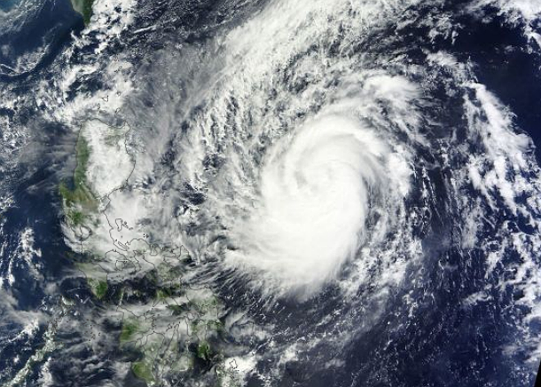
  • Tropical Storm Krosa (Vinta) formed in Philippine Sea

    Tropical Depression 29W organized and strengthened into Tropical Storm Krosa (Vinta) in the Philippine Sea late on October 29, 2013. The system will affect the northernmost parts of Luzon, Philippines and move into the South China Sea after.

    According to latest

  • M 6.2 earthquake struck offshore Maule, Chile

    Strong earthquake registered as M 6.2 (USGS, EMSC) occurred at 02:51 UTC on October 30, 2013. The epicenter was located 9 km (6 miles) SSE of Constitucion and 268 km (167 miles) SW of Santiago, Chile at coordinates 35.413°S

  • M 6.0 earthquake struck Balleny Islands region, Antarctica

    Earthquake registered as M 6.0 (USGS) occurred near uninhabited Balleny Islands in the Southern Ocean at 10:37 UTC on October 29, 2013. Epicenter was recorded at depth of 10 km (6.2 miles). The coordinates of the epicenter are 61.694&d

  • First tropical cyclone of the Southern Indian Ocean season forms

    The first tropical cyclone of the Southern Indian Ocean season lasted about one day. Tropical Cyclone 01S formed on October 27, 2013, about 570 nautical miles northeast of Port Louis, Mauritus. It was moving to the west-southwest at 7 knots (13 km/h, 8 mph). Maximum…