Hurricane “Beryl” leaves 12 people dead in the United States, 16 across the Caribbean

At least 12 people have been killed and millions were left without power in the United States after Category 1 Hurricane “Beryl” made landfall near Matagorda in Texas on July 8, 2024. This brought the total death toll caused by the system to 28, as of July 10.
Beryl formed on June 29 as the second named storm of the 2024 Atlantic hurricane season and soon became the first hurricane and first major hurricane of the season. It was an unusually strong hurricane for the time of year that broke many meteorological records and caused widespread destruction across its path.
Observations from the Hurricane Hunters indicated that Beryl became a major hurricane on June 30. Beryl’s initial intensification culminated with the storm becoming a Category 4 hurricane, attaining an initial peak intensity with winds of 215 km/h (130 mph).
Beryl then underwent an eyewall replacement cycle, weakening slightly going into July 1. The hurricane recovered and quickly re-strengthened, and at 15:10 UTC the same day, Beryl made landfall in Carriacou, Grenada, as a high-end Category 4 hurricane, with sustained winds of 240 km/h (150 mph).
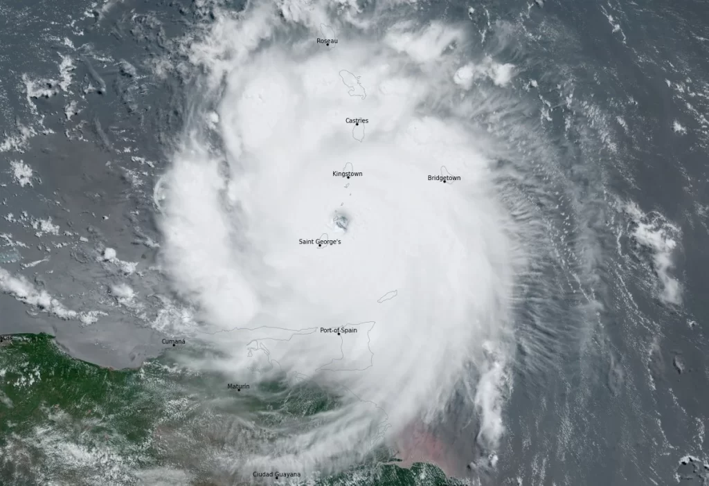
Further intensification took place as Beryl entered the Caribbean Sea, with deep convection cooling around the well-defined eye, and Beryl became a Category 5 hurricane early on July 2. The hurricane peaked later that morning with maximum sustained winds of 270 km/h (165 mph) and a pressure of 934 hPa. Increasing wind shear due to a tropical upper tropospheric trough eventually caused Beryl to slowly weaken to a Category 4 storm as it passed south of the Dominican Republic.
Moving generally west-northwestward under the influence of the strong ridge to its north, Beryl’s eye passed very near the southern coast of Jamaica on the afternoon of July 3. But despite the unfavorable conditions, it remained relatively steady as a Category 4 hurricane.

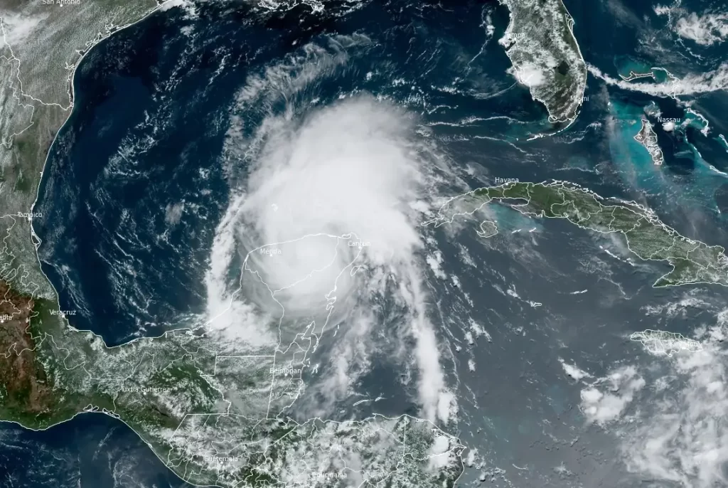
Continued weakening eventually resumed, with Beryl falling below major hurricane intensity on July 4, although it briefly regained Category 3 intensity that evening before weakening once more as the pressure again rose quickly.
At around 11:05 UTC on July 5, the system made landfall just northeast of Tulum, Quintana Roo, Mexico with sustained winds of 175 km/h (110 mph). Beryl quickly weakened due to land interaction, degrading to a tropical storm.
The storm emerged into the Gulf of Mexico the following morning (LT) and steered west-northwestward at 20 km/h (13 mph) by the mid-level ridge located over the southeastern U.S.
That night and into the next day, in addition to a broader inner core, Beryl was beset by an infusion of dry air and by moderate wind shear which kept the storm from strengthening appreciably. Even so, by the afternoon of July 6, its convective structure had improved some and had become more persistent.
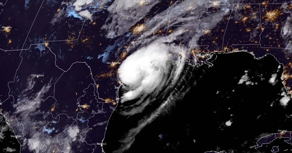
Beryl turned to the north-northwest on July 7, slowed to 17 km/h (10 mph), and re-intensified to hurricane strength near 04:00 UTC on July 8, as its 52 km-wide (32 miles) eye approached the Texas coast.
It then made its third and final landfall at 09:00 UTC near Matagorda, Texas with sustained winds of 130 km/h (80 mph). Eight hours later, the system was downgraded to a tropical storm while centered about 70 km (45 mi) north-northwest of Houston, Texas.
Beryl continued to lose strength that afternoon as it moved quickly north-northeastward at 26 km/h (16 mph). Late that same day, the storm weakened to a tropical depression in the vicinity of Tyler, Texas.
The depression moved quickly to the northeast overnight, and Beryl transitioned into a post-tropical cyclone on the morning of July 9, about 260 km (160 miles) west-southwest of Paducah, Kentucky.
In total, Tropical Cyclone “Beryl” caused at least 28 deaths, as of July 10. Of those, 12 were in the United States, 7 in Saint Vincent and the Grenadines, 3 in Grenada, and 3 in Jamaica.
The fatalities in the United States include 11 in Houston, Texas, and one in Louisiana, with many victims killed by falling trees and flooding.
The storm caused extensive damage in eastern Texas and western Louisiana, with multiple tornadoes reported. A total of 113 tornado warnings were issued by the NWS on July 8 breaking the previous record of 67 tornado warnings issued in a single day, set on July 6, 2005, during the impact of Hurricane “Cindy.” The latest tornado warning, covering Riverside, McCrory, and Grays in Arkansas, remained in effect until 06:45 UTC (01:45 CDT) on July 10, 2024.
The NWS noted that the tornado threat from Beryl was more significant than other impacts, including flash flooding.
Houston, Texas was directly impacted by Beryl’s eyewall. Over 200 mm (8 inches) of rain fell in and around Houston, with a peak rainfall amount for the state being west-southwest of the city at 344 mm (13.55 inches).
Two tornadoes were spotted in Beaumont, one of which caused some roof damage. An EF2 tornado caused major damage on the west side of Jasper, injuring one person. Another passed through the town of Timpson, causing roads to become unpassable with one person trapped.
So far, the damages caused by Beryl are estimated between $750 million to $1.2 billion, according to the BMS group.
Due to the impact of the storm, millions of people in Texas were left without power and air conditioning.
The power outages, which peaked at over 2.7 million on July 8 have reduced to about 2.3 million by the morning of July 9.
Officials said restoring power will take days or even weeks in some areas, which means that many will have to endure the upcoming heat wave without power.
A heat advisory is in effect for the Houston area and beyond through July 10, with temperatures expected to reach the 30s °C (90s °F) and heat indices as high as 40.6 °C (105 °F).
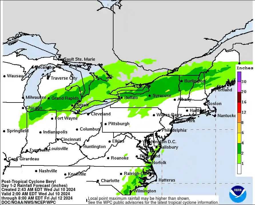
The remnants of Beryl will move through the Ohio Valley and Northeast on Wednesday, July 10, with heavy rainfall which may bring flooding and a few severe thunderstorms with damaging winds and tornadoes.
The NWS Weather Prediction Center said there is a Moderate Risk for Excessive Rainfall for portions of Upstate New York through much of Vermont and northern New Hampshire on July 10 and 11.
Remnant moisture and mid-level energy from Beryl will move northeastward out of the Ohio Valley and Great Lakes, creating a heightened threat for widespread heavy rain and flash flooding across Southeast Michigan through New York and Central/Northern New England.
The highest heavy rain prospects lie within the Adirondacks and points east into north-central Vermont and New Hampshire, including the Green and White Mountains in the respective states.
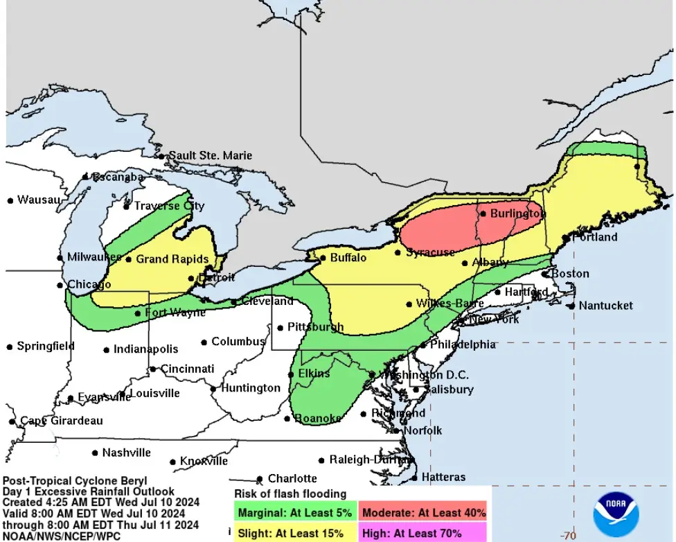
“12z HREF EAS probabilities were much more aggressive in the signals for at least 51 mm (2 inches) and 76 mm (3 inches) across the aforementioned areas, with a 50-80% probability for at least 51 mm (2 inches) within the Adirondacks to just south of the Champlain Valley, a strong signal for higher totals given the necessary overlap of CAMs to exhibit such a large probability,” WPC forecaster Kleebauer said.
“Historically, when an EAS signal is above 70%, the expectation for widespread coverage of that value of rain or more is very certain and warrants a higher risk consideration if the areal FFG indices allow. HREF EAS for 76 mm (3 inches) was not as strong, but still manages a large coverage of 20-35%, with the highest potential across the Adirondacks and northern Mohawk Valley.”
This is right within the inflection of where the warm front is forecast to reside, creating a zone of higher confidence for heavy rainfall. The main prospects for flash flooding will occur between 18:00 UTC Wednesday until about 06:00 UTC across New York state.
Heavy rain will be possible all the way into Maine, where the elevated PWAT anomalies between +2 to +3 standard deviations will be recognized, leading to a higher-end SLGT risk residing from Southeast Michigan all the way into western and central Maine.
Totals of 51 to 102 mm (2 to 4 inches) are anticipated, with local maxima up to 152 mm (6 inches) plausible within the above areas in the Moderate Risk.
Totals of 25 to 76 mm (1 to 3 inches) will be possible as far south as central and northeastern Pennsylvania, up through the NY Capital District, due to convection developing along and ahead of the trailing cold front moving through the area tomorrow afternoon and evening.
Much of the remnant moisture and ascent from Beryl will be out of the region on July 11 into 12; however, additional rainfall of upwards of 25 to 38 mm (1 to 1.5 inches) will be possible across New England, mainly during the morning hours.
Further south, the trailing cold front will be the focus for convective potential, with the highest risk of flash flooding aligning within the Del-Mar-Va Coastal Plain down through the eastern Carolinas. A deep layer of moisture over this region will help bolster rainfall, and with the expected training of cells, 51 to 102 mm (2 to 4 inches) may spread over the Mid-Atlantic.
“Should the guidance persist with this setup and/or trend up with amounts, there may be the need to upgrade the Risk level,” Kleebauer noted.

Hurricane “Beryl” is the easternmost hurricane to form in the tropical Atlantic in June, at 49.3°W, beating the mark set by the 1933 Trinidad hurricane at 58.9°W.
Additionally, it became the earliest Category 4 hurricane on record in the basin, surpassing the previous record set on July 8, 2005, by Hurricane “Dennis”. It also became the strongest June hurricane as measured by wind speed, surpassing Hurricane “Audrey” of 1957.
Hurricane “Beryl” later became the earliest Category 5 hurricane on record, surpassing the record set on July 16, 2005, by Hurricane “Emily”, as well as becoming the strongest July hurricane on record by wind speed and the highest accumulated cyclone energy generating storm before August.
Hurricane “Beryl” also became the first tropical system on record to undergo rapid intensification in the Main Development Region of the Atlantic during the month of June.
Further, it intensified from a tropical storm to a Category 5 hurricane in only 42 hours. Six other Atlantic storms are known to have achieved this rate of intensification, with Hurricane “Beryl” being the only one to do so earlier than September.
References:
1 Post-Tropical Cyclone BERYL Advisory Number 44 – NWS – July 9, 2024
2 Beryl leaves hot misery in the Houston area. It still threatens flooding on its path northward – AP – July 9, 2024
3 National Weather Service in Shreveport set record for most Tornado Warnings issued in single day as Beryl moved through East Texas – CBS19 – July 9, 2024
4 Excessive Rainfall Discussion – NWS/WPC – Day 1 Valid 12Z Wed Jul 10 2024 – 12Z Thu Jul 11 2024
Featured image credit: Donald Sparks/NWS
Commenting rules and guidelines
We value the thoughts and opinions of our readers and welcome healthy discussions on our website. In order to maintain a respectful and positive community, we ask that all commenters follow these rules.