
Magma volume rising, increased likelihood of eruption on Reykjanes Peninsula, Iceland
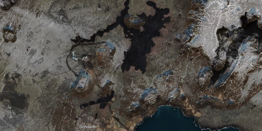
Image credit: Copernicus EU/Sentinel-2, The Watchers. Acquired on March 2, 2024
Magma volume beneath Svartsengi, Reykjanes Peninsula, Iceland continues to increase, which could result in a new dike propagation and/or volcanic eruption in the coming days, the Icelandic Met Office (IMO) reported at 14:00 UTC on March 5, 2024. Weather conditions over the next few days could affect IMO’s monitoring system.
The likely scenarios over the next few days include the continued increase in magma volume within the Svartsengi reservoir, which could result in a new dike propagation and/or volcanic eruption. A volcanic eruption could start with very little warning time, even less than 30 minutes. The most likely location for an eruption is between Mt. Stóra-Skógfell and Mt. Hagafell.
While seismicity over the dike has been low since the magma propagation ended on Saturday, March 2, there has been slightly more activity at Mt. Fagradalsfjall, where around 20 earthquakes have been detected in the last 24 hours.
Model calculations indicate a volume loss of about 1.3 million m3 (46 million ft3) from the Svartsengi magma reservoir on Saturday, which fed a 3 km (1.8 miles) long dike intrusion between Mt. Stóra-Skógfell and Mt. Hagafell.
The volume loss from the Svartsengi reservoir was much lower than that which occurred during previous events, where a volume loss of about 10 million m3 (353 million ft3) was calculated.
Continuous land uplift is detected on GNSS observations since Saturday‘s magma propagation. Magma inflow beneath Svartsengi thus continues and model calculations suggest an inflow/accumulation rate of about 500 000 m3 (17.6 million ft3) per day, making a total of about 9.5 million m3 (335.5 million ft3) of magma recharged to the reservoir beneath Svartsengi since the eruption on February 8 and 9.
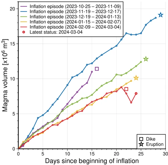
“Therefore, pressure in the magma reservoir continues to build up, and there is an increased likelihood of another dike propagation within the Sundhnúkur crater row and/or a volcanic eruption in the coming days,” IMO said.
The hazard assessment map is unchanged from the previous hazard assessment and is valid until March 7, unless developments in activity call for a re-evaluation.
Weather conditions over the next few days could affect IMO’s monitoring system, further complicating eruption forecasting.
Read more:
References:
1 Increased likelihood of eruption – IMO – March 5, 2024
I'm a dedicated researcher, journalist, and editor at The Watchers. With over 20 years of experience in the media industry, I specialize in hard science news, focusing on extreme weather, seismic and volcanic activity, space weather, and astronomy, including near-Earth objects and planetary defense strategies. You can reach me at teo /at/ watchers.news.
Commenting rules and guidelines
We value the thoughts and opinions of our readers and welcome healthy discussions on our website. In order to maintain a respectful and positive community, we ask that all commenters follow these rules.