
Powerful winter storm to rapidly strengthen over the Central U.S. early next week
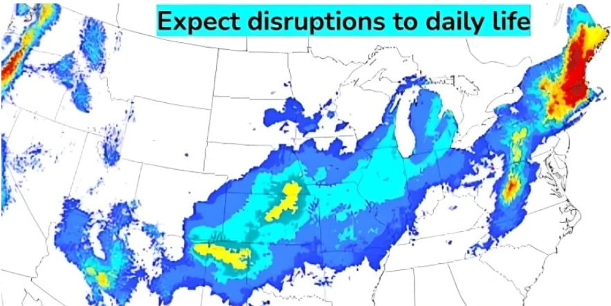
Image credit: NWS/WPC
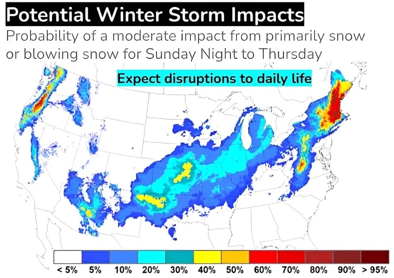
The United States braces for a powerful winter storm, forecasted to strengthen rapidly over the Central region early next week, affecting areas from the West to the East Coast. According to NWS predictions on Thursday, January 4, 2024, the storm may bring heavy snow, blizzard conditions, destructive winds exceeding 80 km/h (50 mph), and heightened flooding risks.
As one winter storm affects the Northeast this weekend, another winter storm will arrive on the West Coast. The next storm will then rapidly strengthen over the Central U.S. and progress to the East Coast early next week.
While there is still some uncertainty in the exact track and details of the storm, heavy snow is likely in the higher elevations of the Western U.S. this weekend; in a swath over parts of the Southern High Plains, Central Plains, and Midwest Monday and Tuesday, January 8 and 9; and in the interior Northeast Tuesday and Wednesday, January 9 and 10. Given the intensity of the storm, strong winds may create areas of blizzard conditions.
NWS is urging residents living in affected areas to continue checking for forecast updates as the area of greatest threat will become clearer in the coming days.
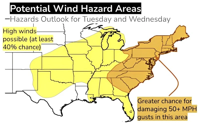
Gusty winds are expected on the warm side of the storm too, and may exceed 80 km/h (50 mph) and cause damage, even outside of thunderstorm activity. The strongest gusts are most likely near the Appalachians and on the East Coast.
Heavy rain on Tuesday and Wednesday is likely to lead to flooding, including river flooding, in the Eastern U.S. Powerful onshore winds are also likely to lead to coastal flooding issues along much of the East Coast.
NWS forecaster Otto has noted an upper-level disturbance tracking eastward tonight from the southern Rockies into the central and southern Great Plains. Eastern Colorado and northeastern New Mexico are expected to receive mostly light to moderate snowfall accumulations through early Friday morning, spreading eastward into parts of Kansas throughout the day.
Farther south, a cold rain will affect regions into Oklahoma, Texas, and the Lower Mississippi Valley. Warm and weakly unstable air moving northward through the Gulf of Mexico will reach the Gulf Coast by Friday into Saturday, heightening the risk of strong to severe thunderstorms, heavy rain, and localized flash flooding.
As the storm system continues eastward through Friday night, southeastern U.S. states will see rain overspreading the region as low pressure advances toward the Carolinas.
Freezing rain is expected in parts of the southern and central Appalachians, with significant ice accumulations over 2.5 cm (0.1 inches) impacting travel.
The storm’s track northward along the Mid-Atlantic coast on Saturday is likely to bring rain mainly to the I-95 corridor from New York City southward, although some areas may begin with light snow. Interior regions of the Mid-Atlantic and Northeast are more likely to see accumulations as the storm persists through Saturday night.
In the Western U.S., a temporary lull in precipitation is anticipated behind a weakening cold front and upper-level disturbance on Friday. However, a stronger storm system is expected to reach the Pacific Northwest by Friday night, bringing coastal rain and mountain snow. Heavy snow is possible for the Cascades and parts of the northern Rockies.
As the disturbance moves inland on Saturday, precipitation will move southward along the West Coast, affecting California with heavy snow anticipated in the Sierra Nevada.
References:
1 Key Messages for Jan 8-11 Major Winter Storm – NWS/WPC – January 4, 2024
2 Short Range Forecast Discussion – NWS Weather Prediction Center College Park MD – 301 PM EST Thu Jan 04 2024
I'm a dedicated researcher, journalist, and editor at The Watchers. With over 20 years of experience in the media industry, I specialize in hard science news, focusing on extreme weather, seismic and volcanic activity, space weather, and astronomy, including near-Earth objects and planetary defense strategies. You can reach me at teo /at/ watchers.news.
Commenting rules and guidelines
We value the thoughts and opinions of our readers and welcome healthy discussions on our website. In order to maintain a respectful and positive community, we ask that all commenters follow these rules.