
Major lake-effect snow event expected in Great Lakes region, threatening road closures and power outages
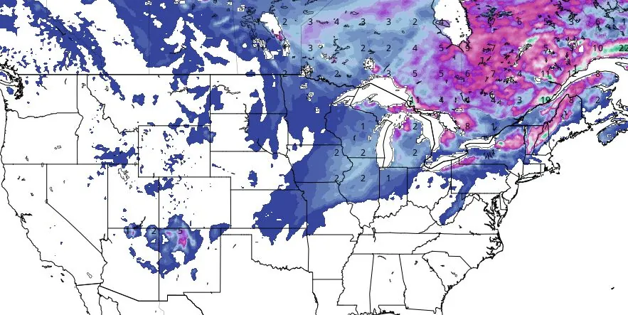
Image credit: GFS Total Snowfall November 26 - December 1, 2023
As Arctic air sweeps across the Great Lakes, meteorologists are warning of the season’s first significant lake-effect snow event, poised to cause travel disruptions and potentially feet of snow in some areas. This weather phenomenon, intensifying early next week, is expected to bring hazardous conditions, particularly along I-90 and in snow-prone regions of Michigan, Ohio, and New York.
The upcoming week will see some of the coldest air of the season over the Great Lakes, triggering a significant lake-effect snow event. AccuWeather senior meteorologist Alex Sosnowski notes this will be the first major snow event of the season, with potential travel disruptions from the Upper Midwest to the interior Northeast. Feet of snow (equivalent to several meters) are possible in some locations, leading to dangerous travel conditions.
AccuWeather Storm Warning Meteorologist Jake Sojda warns of the intensity of this lake-effect snow, which could lead to temporary road closures. The event will develop as three storms converge over eastern Ontario and Quebec, Canada, creating a large storm system. This system will strengthen, bringing gusty winds and funneling Arctic air across the Great Lakes, leading to varying snow conditions, including heavy bands and snow squalls. Thundersnow, a phenomenon involving thunder and lightning during a snowstorm, is also possible.
The unpredictability of lake-effect snow poses a significant risk to travelers, with visibility dropping suddenly in heavy snow bands and squalls. Combined with strong winds, this can lead to power outages and rapidly changing road conditions. Sojda highlights the risk along I-90 from Buffalo, New York, to Cleveland, with other prone areas including Interstate 81 in New York and Interstates 94 and 196 in Michigan.
Snowfall is expected to exceed 30 cm (1 foot) in parts of Michigan, Ohio, and New York, with some areas potentially receiving over 90 cm (3 feet) of snow. Northwestern Indiana will also experience several cm of snow. The lake-effect snow is expected to diminish in Michigan and Indiana by Tuesday night, November 28 but may persist in eastern areas until Wednesday or Thursday, November 29 and 30.
An Alberta clipper storm from Canada will influence the pattern, potentially enhancing snowfall in some areas and bringing new bands of lake-effect snow later in the week. This cold, blustery pattern will be the most persistent of its kind this season.
Strong winds from the Arctic air outbreak will create low AccuWeather RealFeel® Temperatures, with frequent wind gusts between 48 and 80 km/h (30 and 50 mph) near the Great Lakes, and a maximum gust of 104 km/h (65 mph), potentially causing sporadic power outages.
RealFeel® Temperatures will be up to 11 °C (20 °F) lower than the actual temperature and even minus double digits Celsius (teens Fahrenheit) in northern areas.
The persistent winds will also impact lake shorelines, with overwash and freezing spray likely in some areas, adding to the challenges posed by this significant lake-effect snow event.
References:
1 1st significant, widespread lake-effect snow event of the season to threaten travel – AccuWeather – November 24/26, 2023
2 Short Range Forecast Discussion – NWS Weather Prediction Center College Park MD – 300 AM EST Sun Nov 26 2023
I'm a dedicated researcher, journalist, and editor at The Watchers. With over 20 years of experience in the media industry, I specialize in hard science news, focusing on extreme weather, seismic and volcanic activity, space weather, and astronomy, including near-Earth objects and planetary defense strategies. You can reach me at teo /at/ watchers.news.
Commenting rules and guidelines
We value the thoughts and opinions of our readers and welcome healthy discussions on our website. In order to maintain a respectful and positive community, we ask that all commenters follow these rules.