
Nearly 17 000 people evacuating due to unrest at Mayon volcano, Philippines
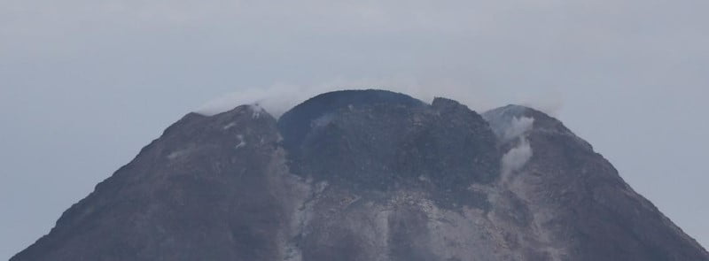
Image credit: PHIVOLCS
The Mayon volcano in the province of Albay, Bicol Region, central Philippines, is showing signs of increased activity since June 5, 2023, when the Alert Level was raised to 2. On June 8, the Alert Level was raised to 3, prompting authorities to issue evacuation orders for all residents living within a 6 km (6 miles) radius of the crater — about 17 000 people. Another 40 000 people will have to evacuate if the Alert Level is raised to 4.
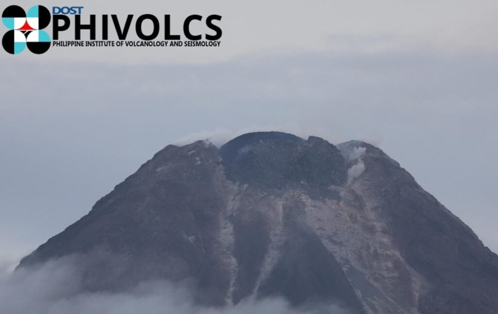
The alert status of Mayon Volcano was raised to Alert Level 2 (Increasing Unrest) on June 5, 2023, following a sharp increase in the incidence of rockfall from its summit lava dome from an average of 5 events/day in May 2023 to 49 events/day on June 5, 2023.
Pronounced increases in rockfall signify the extrusion of new lava beneath the summit lava dome, destabilizing the dome and causing its spalling or collapse, the Philippine Institute of Science and Technology (PHIVOLCS) said.1
Rockfall activity increased while volcanic earthquake activity was absent to sparse, SO2 emissions were at background or baseline levels and short-term ground deformation consisted mainly of swelling of the middle to upper slopes of the edifice. The extremely slow growth of Mayon’s lava dome was first detected by visual monitoring on August 20, 2022, warranting the raise to Alert Level 2 on October 7, 2022, which was lowered to Alert Level 1 on March 16, 2023. Between August 2022 and May 2023, the summit lava dome grew by approximately 164 000 m3.
Days of increased incidence and volume of rockfall based on seismic records were followed by the generation of short pyroclastic density currents (PDCs) during the morning hours (LT) of June 8.
The PDCs were emplaced on the Bonga (Legaspi City), Miisi (Daraga), and Basud (Sto. Domingo) Gullies as far as 2 km (1.2 miles) from the summit crater.
This indicated that new, less degassed lava was already being spalled from the summit dome and that eruption of very slowly extruding magma had slightly increased.
Alert Level 3 (Increased Tendency Towards Hazardous Eruption) was raised at 12:00 LT on June 8. In the evening thereof, incandescent rockfall generated by the intermittent collapse of an apparent fluidal lava portion of the summit dome was deposited on the above gullies within 1 km (6.2 miles) of the crater.
A new summit dome impinging a remnant on the southeast crater floor was observed in the early morning of June 10.
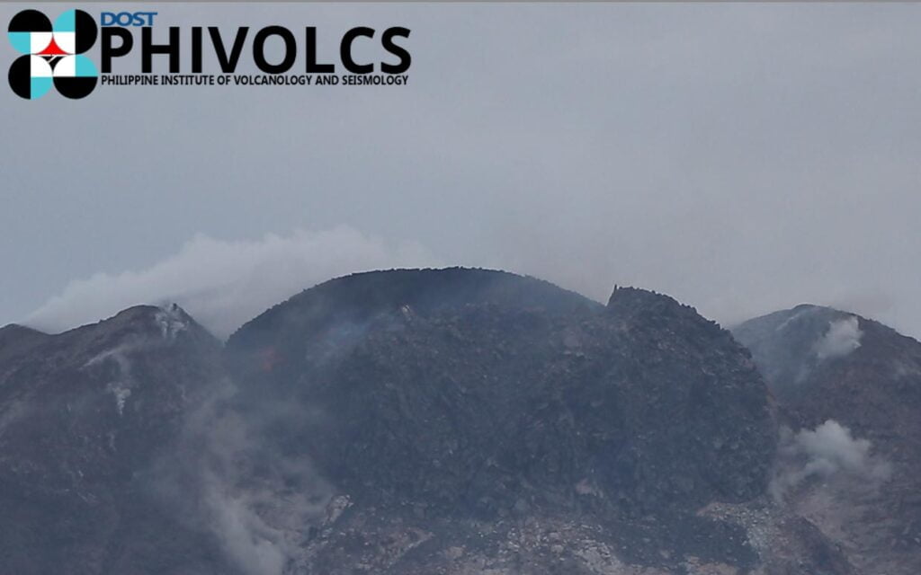
As of 19:00 LT on June 10, a total of 654 rockfall events since June 1 and 7 PDCs have been recorded by the Mayon Volcano Network. Average SO2 flux increased beyond baseline levels today to 1 205 tonnes/day. All other monitoring parameters remain unchanged.
As a result of increased activity at the volcano, Albay province was placed in a state of calamity on June 9.
On June 10, President Ferdinand R. Marcos Jr. said government funds and food packs are available for those who will be affected by the possible eruption. “Residents who are within the 6 km (3.7 miles) radius permanent danger zone are being evacuated,” Marcos said and urged affected residents to heed the instructions and directives of their local government officials to ensure their safety.2
Data from the Albay Public Safety Emergency Management Office showed 4 390 families or 16 823 individuals from nine municipalities namely, Camalig, Daraga, Guinobatan, Ligao City, Malilipot, Tabaco City, Sto. Domingo, Bacacay and Legazpi City, are affected.
Another 40 000 individuals are set to be evacuated from the 7 km (4.3 miles) extended danger zone if Mayon’s status is escalated to Alert Level 4.
PHIVOLCS said possible hazards that can occur are rockfalls, landslides or avalanches; ballistic fragments; lava flows and lava fountaining; pyroclastic density currents; and moderate-sized explosions.
Alert Level 3, according to the agency, means magma is near or at the surface, and activity could lead to a hazardous eruption in weeks. Occurrences of low-frequency earthquakes, volcanic tremor, and rumbling sounds are also likely.
Current outlook:
Ongoing slow extrusive eruption of new lava at the summit is currently accompanied by moderately elevated SO2 and low-level seismic and ground deformation parameters. This state of unrest may progress into the following eruption scenarios under various changes in monitored parameters:
a) Slow lava dome and short lava flow extrusion (e.g. 2014 eruption), if the current rate of extrusion and low-level parameters persist. Activity may persist for a few months. Alert Level 3 is maintained.
b) Slow and sustained lava extrusion (e.g. 2006 eruption), if apparent rates of extrusion increase, SO2 emission increases persist and seismic activity (e.g. low-level tremor) and a cycle of inflation (swelling) and deflation (unswelling) of the edifice occur. Activity may last for a few months. Alert Level 4 will be raised.
c) Lava fountaining and lava flow with occasional explosions and PDCs within the 6km-PDZ (e.g. 2018 eruption), if significant increases in SO2 emission, increased seismicity (low-frequency and tremor events) and inflation (swelling) of the entire edifice occur. Activity may last for a few months. Alert Level 4 will be raised.
d) Explosive eruption with high-intensity lava fountaining, long lava flows, and PDCs on all sectors that could exceed the 6km-PDZ (e.g. 2000 eruption), if rapid escalation in SO2 (or sudden drop), volcanic earthquake activity, and ground deformation occur. Activity may last for a few days to weeks. Alert Level 5 will be raised.
Geological summary
Beautifully symmetrical Mayon volcano, which rises to 2 462 m (8 077 feet) above the Albay Gulf, is the Philippines’ most active volcano.
The structurally simple volcano has steep upper slopes averaging 35-40 degrees that are capped by a small summit crater. Historical eruptions at this basaltic-andesitic volcano date back to 1616 and range from strombolian to basaltic plinian, with cyclical activity beginning with basaltic eruptions, followed by longer-term andesitic lava flows.
Eruptions occur predominately from the central conduit and have also produced lava flows that travel far down the flanks.
Pyroclastic flows and mudflows have commonly swept down many of the approximately 40 ravines that radiate from the summit and have often devastated populated lowland areas.
Mayon’s most violent eruption, in 1814, killed more than 1 200 people and devastated several towns.3
References:
1 MAYON VOLCANO BULLETIN – PHIVOLCS – June 10, 2023
2 Marcos assures funds, food packs ready amid Mayon unrest – PNA – June 10, 2023
3 Mayon – Geological summary – GVP
I'm a dedicated researcher, journalist, and editor at The Watchers. With over 20 years of experience in the media industry, I specialize in hard science news, focusing on extreme weather, seismic and volcanic activity, space weather, and astronomy, including near-Earth objects and planetary defense strategies. You can reach me at teo /at/ watchers.news.
Commenting rules and guidelines
We value the thoughts and opinions of our readers and welcome healthy discussions on our website. In order to maintain a respectful and positive community, we ask that all commenters follow these rules.