
Major spring blizzard to hit southern Prairies and Ontario – potentially the worst in decades, Canada
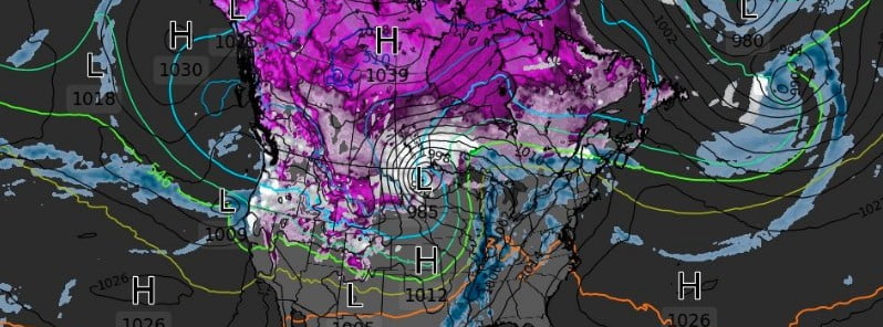
Image credit: WXcharts.com
A major spring blizzard is forecast to hit southern Prairies and parts of Ontario, Canada this week, with widespread snowfall accumulations of 30 – 50 cm (12 – 20 inches) accompanied by northerly winds gusting 70 – 90 km/h (45 – 55 mph) giving zero visibility at times in snow and blowing snow.
- Winter storm watches are in effect for SE Saskatchewan, southern Manitoba and NW Ontario.
- Do not plan to travel – this storm has the potential to be the worst blizzard in decades, Environment Canada warns.
- Stock up on needed supplies and medications now. Power outages are likely, rural areas in particular should be prepared for extended outages.
- Public Safety Canada encourages everyone to make an emergency plan and get an emergency kit with drinking water, food, medicine, a first-aid kit, and a flashlight.
A Colorado low will move towards Minnesota Tuesday night bringing a heavy swath of snow from southeastern Saskatchewan through most of southern Manitoba.1
The snow will start early Tuesday evening (LT), April 12 near the International border and then push northward throughout the night.
By Wednesday morning heavy snow will be falling in much of the area as the storm continues to push northward. Strong northerly winds will develop with this system and persist into Friday morning as the low slowly pivots through Minnesota on its way into northwestern Ontario.
By Friday morning, April 15 widespread snowfall accumulations of 30 – 50 cm (12 – 20 inches) are expected, with possible accumulations as high as 80 cm (31 inches) possible along terrain features such as the western escarpment of the Red River Valley, the Riding Mountains, and the Turtle Mountains.
Travel will become increasingly difficult as the day progresses Wednesday, with widespread highway closures a near certainty.
By Wednesday evening even travel within communities may become impossible as the heavy snow and strong winds continue, and more of the same is expected on Thursday.
Conditions should begin to improve on Friday as the winds taper off and the heaviest snow moves into northern Ontario.
References:
1 Winter storm watch issued by Environment Canada at 4:04 PM CDT – April 11, 2022
I'm a dedicated researcher, journalist, and editor at The Watchers. With over 20 years of experience in the media industry, I specialize in hard science news, focusing on extreme weather, seismic and volcanic activity, space weather, and astronomy, including near-Earth objects and planetary defense strategies. You can reach me at teo /at/ watchers.news.
Thanks for this important message.
Mardel Mitchell