
Phreatomagmatic eruption at Taal volcano, Alert Level raised to 3, Philippines
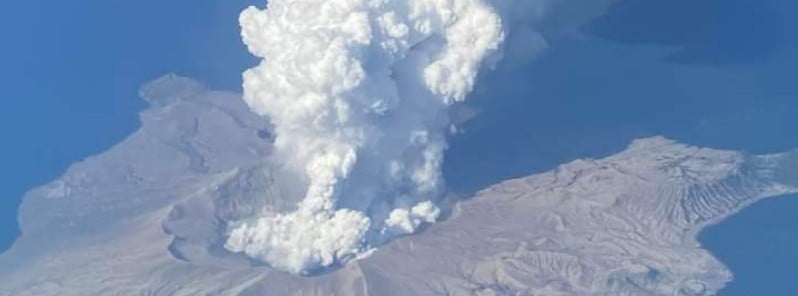
Image credit: Enelra
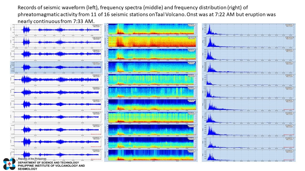
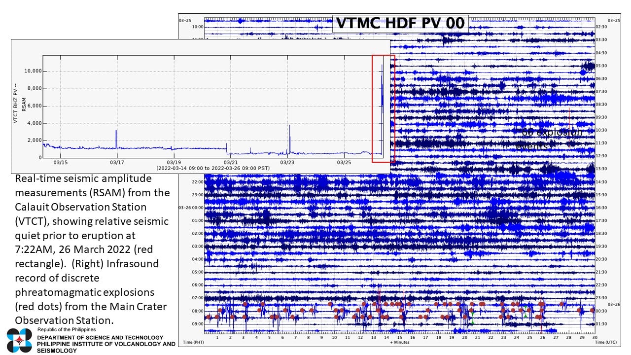
The Philippine Institute of Volcanology and Seismology (PHIVOLS) has raised the alert status of Taal volcano from Alert Level 2 (increasing unrest) to Alert Level 3 (magmatic unrest) after a phreatomagmatic eruption at 23:22 UTC on March 25, 2022 (07:22 LT, March 26).
The eruption was short-lived, followed by a nearly continuous phreatomagmatic activity that generated plumes 1.5 m (4 900 feet) above the crater, accompanied by volcanic earthquakes and infrasound signals.
According to the Tokyo VAAC, volcanic ash was continuously observed in satellite imagery rising up to 3.3 km (11 000 feet) a.s.l. at 05:20 UTC on March 26, moving W at 28 km/h (17 mph).
In view of the above, DOST-PHIVOLCS raised the Taal’s alert status from Alert Level 2 to Alert Level 3.
“This means that there is magmatic intrusion at the Main Crater that may further drive succeeding eruptions,” the Institute said.
PHIVOLCS strongly recommends Taal Volcano Island and high-risk barangays of Bilibinwang and Banyaga, Agoncillo and Boso-boso, Gulod and eastern Bugaan East, Laurel, Batangas Province be evacuated due to the possible hazards of pyroclastic density currents and volcanic tsunami should stronger eruptions subsequently occur.
The public is reminded that the entire Taal Volcano Island is a Permanent Danger Zone (PDZ), and entry into the island as well as high-risk barangays of Agoncillo and Laurel must be prohibited.
#Taal Volcano, 26.03.2022, timelapse
source: Taal Meditation, https://t.co/P1H3db0nDf
visit VolcanoVerse: https://t.co/gAMLAjyiSy pic.twitter.com/TNZBI77tQa— Rita Bauer (@wischweg) March 26, 2022
A netizen capture these Taal from the airplane window of Manila – Caticlan flight 8am this morning.#taalvolcano #taal #prayforBatangas pic.twitter.com/GEhpYGiKJq
— Enelra (@EOtirolf) March 26, 2022
On 2022-03-26 #TROPOMI has detected a strong SO2 signal at a distance of 113.2km to #Taal with 18.14DU of SO2 at an altitude of ~2km. Estimated mass within 300km: 6.0ktons. @tropomi #S5p #Sentinel5p @DLR_en @BIRA_IASB @ESA_EO #SO2LH pic.twitter.com/qvCVooaCF8
— TROPOMI SO2 (@DlrSo2) March 26, 2022
taal in our view
keep safe everyone ! pic.twitter.com/DqXvFEH8LJ— aki. (@kkukkthv) March 26, 2022
Taal activity as of 8:16am today. pic.twitter.com/xLCdoqw3KZ
— NING SHU CAN STEP ON ME (@canyixingforme) March 26, 2022
To everyone living near Taal Volcano. Be safe and alert!!! Praying for everyone’s safety#Taal pic.twitter.com/t6hP8gTzCC
— (@heraofharu) March 26, 2022
Not now #Taal pic.twitter.com/MSScVHoqtT
— Patt (@sirkyanxxi) March 26, 2022
Communities around the Taal Lake shores are advised to remain vigilant, take precautionary measures against possible airborne ash and vog and calmly prepare for possible evacuation should unrest intensify.
Civil aviation authorities advised pilots to avoid flying over Taal Volcano Island as airborne ash and ballistic fragments from sudden explosions and pyroclastic density currents such as base surges may pose hazards to aircraft.
“As compared to January 2020, the magma is slowly rising and explosions are not as explosive,” PHIVOLCS director Renato Solidum said.
“What we need to do right now is to monitor if magma will rise from below and how fast it will rise. Because if the magma rises fast, it will trigger a strong eruption.”
The Philippine Coast Guard (PCG), which was evacuating residents from the area, observed that the volcano has since calmed down.2
Geological summary
Taal is one of the most active volcanoes in the Philippines and has produced some of its most powerful historical eruptions. Though not topographically prominent, its prehistorical eruptions have greatly changed the topography of SW Luzon.
The 15 x 20 km (9 x 12 miles) Talisay (Taal) caldera is largely filled by Lake Taal, whose 267 km2 (103 mi2) surface lies only 3 m (9.8 feet) above sea level.
The maximum depth of the lake is 160 m (525 feet), and several eruptive centers lie submerged beneath the lake. The 5 km (3.1 miles) wide Volcano Island in north-central Lake Taal is the location of all historical eruptions.
The island is composed of coalescing small stratovolcanoes, tuff rings, and scoria cones that have grown about 25% in the area during historical time. Powerful pyroclastic flows and surges from historical eruptions have caused many fatalities.3
References:
1 TAAL Volcano bulletin update – 00:00 UTC on March 26, 2022 – PHIVOLCS
2 Taal Volcano elevated to Alert Level 3 after phreatomagmatic eruption – CNN Philippines
3 Geological summary – Taal volcano – GVP
I'm a dedicated researcher, journalist, and editor at The Watchers. With over 20 years of experience in the media industry, I specialize in hard science news, focusing on extreme weather, seismic and volcanic activity, space weather, and astronomy, including near-Earth objects and planetary defense strategies. You can reach me at teo /at/ watchers.news.
Commenting rules and guidelines
We value the thoughts and opinions of our readers and welcome healthy discussions on our website. In order to maintain a respectful and positive community, we ask that all commenters follow these rules.