
Sequence of tectonic earthquakes under the summit of Ruapehu volcano, New Zealand
Image credit: GeoNet
Tectonic earthquakes are being registered beneath the summit area of Ruapehu volcano in New Zealand since December 30, 2021. While these earthquakes are uncommon, none of the monitoring data suggests that the volcano is exhibiting increased levels of activity.
"Earthquakes regularly occur in the Tongariro National Park, and towards the southern portion around Ruapehu, we often record them near Waiouru and National Park Village," GNS Duty Volcanologist Geoff Kilgour noted.1
There are two broad styles of earthquakes at volcanoes: volcanic earthquakes (which includes tremors) that are directly related to the movement of fluids (magma and/or the hydrothermal system), and tectonic earthquakes which result from rocks fracturing (movement on small faults).
From December 30, 2021, GeoNet has recorded a sequence of tectonic earthquakes located beneath Ruapehu’s summit area. So far, there have been at least 30 distinct earthquakes in this sequence.
When compared to historical records, the number of earthquakes with epicenters closely confined to the summit area is unusual.
However, while these earthquake clusters are uncommon, none of the monitoring data suggests that the volcano is exhibiting increased levels of activity.
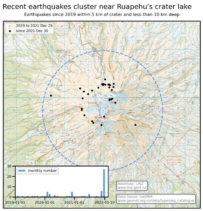
Image credit: GeoNet
There has been no observable response from other continuous monitoring data such as Crater Lake (Te Wai ā-moe) temperature, lake level, or volcanic tremor.
"Therefore, our current assessment is that a relatively deep stress release has occurred below the volcano, but this has not affected the volcano's hydrothermal system," Kilgour said.
"Our team will be conducting a scheduled gas flight and will sample Ruapehu’s Crater Lake (Te Wai ā-moe) in the coming days, weather permitting."
The Volcanic Alert Level for Ruapehu stays at Level 1, which reflects the current level of volcanic unrest, and the Aviation Colour Code remains at Green.
Kilgor added that Ruapehu is an active volcano with the potential to erupt with little or no warning when in a state of volcanic unrest.
Volcanic Alert Level 1 indicates the primary hazards are those expected during volcanic unrest: steam discharge, volcanic gas, earthquakes, landslides and hydrothermal activity.
While Volcanic Alert Level 1 is mostly associated with environmental hazards, eruptions can still occur with little or no warning.
Geological summary
Ruapehu, one of New Zealand's most active volcanoes, is a complex stratovolcano constructed during at least four cone-building episodes dating back to about 200 000 years ago.
The 110 km3 (26.4 mi3) dominantly andesitic volcanic massif is elongated in a NNE-SSW direction and surrounded by another 100 km3 (24 mi3) ring plain of volcaniclastic debris, including the Murimoto debris-avalanche deposit on the NW flank.
A series of subplinian eruptions took place between about 22 600 and 10 000 years ago, but pyroclastic flows have been infrequent. A single historically active vent, Crater Lake, is located in the broad summit region, but at least five other vents on the summit and flank have been active during the Holocene.
Frequent mild-to-moderate explosive eruptions have occurred in historical time from the Crater Lake vent, and tephra characteristics suggest that the crater lake may have formed as early as 3 000 years ago. Lahars produced by phreatic eruptions from the summit crater lake are a hazard to a ski area on the upper flanks and to lower river valleys.2
References:
1 Recent earthquakes under the summit of Ruapehu – unrest remains low – GeoNet
2 Ruapehu – Geological summary – GVP
I'm a dedicated researcher, journalist, and editor at The Watchers. With over 20 years of experience in the media industry, I specialize in hard science news, focusing on extreme weather, seismic and volcanic activity, space weather, and astronomy, including near-Earth objects and planetary defense strategies. You can reach me at teo /at/ watchers.news.
Commenting rules and guidelines
We value the thoughts and opinions of our readers and welcome healthy discussions on our website. In order to maintain a respectful and positive community, we ask that all commenters follow these rules.