
Tropical Cyclone “Ruby” makes landfall in New Caledonia, heading toward New Zealand
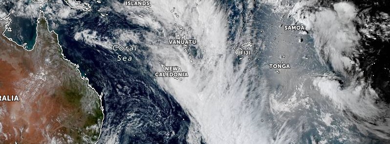
Image credit: JMA/Himawari-8, Zoom Earth, TW. Acquired at 04:30 UTC on December 14, 2021
Tropical Cyclone "Ruby" formed on December 12, 2021, as the first named storm of the 2021/22 South Pacific cyclone season. Ruby made landfall in western New Caledonia on December 14, moving fast toward the middle of the island with winds of 110 km/h (70 mph). This placed it on the upper edge of Category 2 Cyclone.
At 06:00 UTC on December 14, the center of Tropical Cyclone "Ruby" was located approximately 120 km (75 miles) north-northwest of Nouméa, New Caledonia.
Ruby's maximum 10-minute sustained winds were 100 km/h (65 mph), maximum 1-minute sustained winds were 100 km/h (65 mph), gusting up to 130 km/h (80 mph). The minimum barometric pressure was 981 hPa and the system was moving southeast at 30 km/h (20 mph).
The cyclone will continue bringing periods of heavy rain and strong winds to majority of New Caledonia today. Residents are urged to pay close attention to official weather updates.
Ruby will likely be clearing from New Caledonia by tonight, followed by high humidity and calmer conditions.1
At 08:00 UTC on December 14, Ruby was a strong tropical depression, moving SE at approximately 35 km/h (22 mph) and generating gusts of 140 km/h (87 mph) near its center, according to Meteo France – New Caledonia.
Maximum gusts of 162 km/h (100 mph) were registered at Montagne des Sources and 135 km/h (84 mph) at Nouméa.
Over the past 48 hours, the weather station at Méa (Kouaoua) registered 405 mm (15.9 inches) of rain.
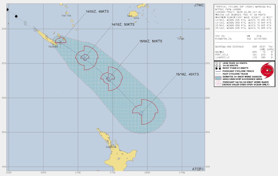
After moving over New Caledonia, the storm will head toward New Zealand.
"Ruby’s path to New Zealand is complicated – it’s likely to get swallowed up by a ‘mega’ low in the New Zealand area which will contribute to more wind and rain in the NZ area, but not as a direct single storm moving in. In fact, the center of Ruby’s remnants may well miss New Zealand out to the east," WeatherWatch meteorologists said.
The New Zealand MetService has issued an Orange alert for heavy rain.
"A complex low pressure system affects central and northern New Zealand through to early Thursday, delivering rain to many places," MetService said.2
Heavy Rain Warnings and Watches are in force for parts of the North Island, northwest Tasman, Canterbury, and Marlborough. Note, winds may approach severe gale over Auckland, Buller, and northern Westland.
People are advised to keep up to date with the latest forecasts in case any changes are made or further areas are added.
NZ Heavy Rain Warning – Orange
Impact: Heavy rain may cause streams and rivers to rise rapidly. Surface flooding and slips are also possible and driving conditions may be hazardous.
- Area: Coromandel Peninsula
- Period: 8 hours from 20:00 LT on December 14 – 04:00 on December 15
- Forecast: Periods of heavy rain. Expect 60 to 80 mm (2.4 – 3.1 inches) of rain to accumulate, especially about the ranges. Peak rates of 10 to 20 mm/h (0.4 – 0.8 inches per hour) about the ranges.
- Area: Bay of Plenty
- Period: 19 hours from 20:00 LT on December 14 – 15:00 on December 15
- Forecast: Expect a further 70 to 100 mm (2.7 – 4 inches) of rain, but 150 to 180 mm (5.9 – 7 inches) about inland areas east of Whakatane, on top of what has already fallen. Peak intensities of 20 to 30 mm/h (0.8 – 1.2 inches per hour) in the east Wednesday morning.
- Area: Gisborne from Tokomaru Bay northwards
- Period: 17 hours from 23:00 LT on December 14 – 16:00 on December 15
- Forecast: Expect 120 to 160 mm (4.7 – 6.3 inches) of rain about and north of Ruatoria, and 70 to 100 mm (2.7 – 4 inches) from south of Ruatoria to Tokomaru Bay. Peak intensities of 15 to 25 mm/hr (0.6 – 1 inches per hour) in the north.
- Area: Tasman, about and west of Motueka
- Period: 15 hours from 23:00 LT on December 14 to 14:00 on December 15
- Forecast: Expect 80 to 100 mm (3 – 4 inches) of rain. Peak intensities of 10 to 20 mm/h (0.4 – 0.8 inches per hour).
- Area: Eastern Marlborough south of Blenheim
- Period: 19 hours from 23:00 LT on December 14 – 18:00 on December 15
- Forecast: Expect 100 to 180 mm (4 – 7 inches) of rain to accumulate, especially about Kaikoura Coast. Peak rates of 15 to 25 mm/h (0.6 – 1 inches per hour).
- Area: Canterbury Plains north of Ashburton, including the foothills and Christchurch
- Period: 24 hours from 03:00 LT on December 15 to 03:00 on December 16
- Forecast: Periods of heavy rain. Expect 100 to 140 mm (4 – 5.5 inches) of rain to accumulate, especially north of Christchurch. Peak rates of 15 to 25 mm/h (0.6 – 1 inches per hour). Note, heavy rain is expected to ease north of Christchurch after midnight Wednesday.
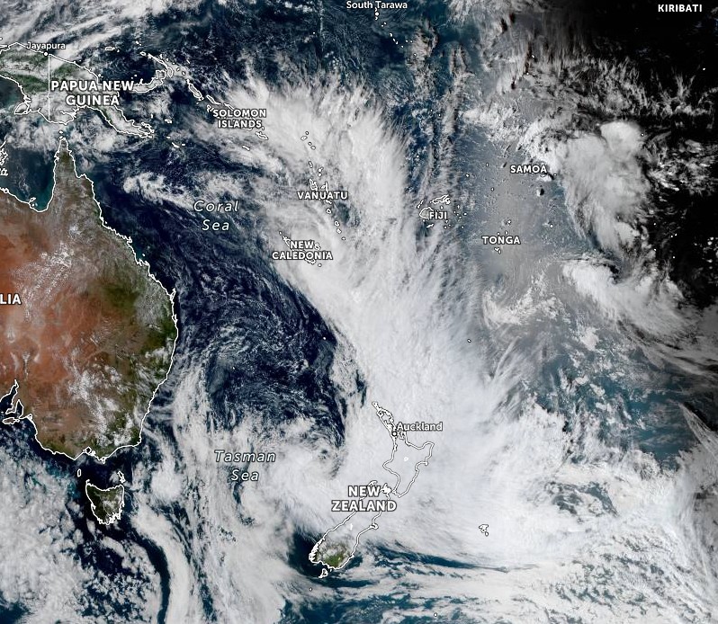
Image credit: JMA/Himawari-8, Zoom Earth, TW. Acquired at 04:30 UTC on December 14, 2021
References:
1 Tropical Cyclone Ruby makes landfall in New Caledonia as strong Category 2 storm – WeatherWatch
2 Heavy Rain Warning – Orange – NZ MetService
I'm a dedicated researcher, journalist, and editor at The Watchers. With over 20 years of experience in the media industry, I specialize in hard science news, focusing on extreme weather, seismic and volcanic activity, space weather, and astronomy, including near-Earth objects and planetary defense strategies. You can reach me at teo /at/ watchers.news.
Commenting rules and guidelines
We value the thoughts and opinions of our readers and welcome healthy discussions on our website. In order to maintain a respectful and positive community, we ask that all commenters follow these rules.