
Atmospheric river hits southern Alaska, dropping historic rainfall, U.S.
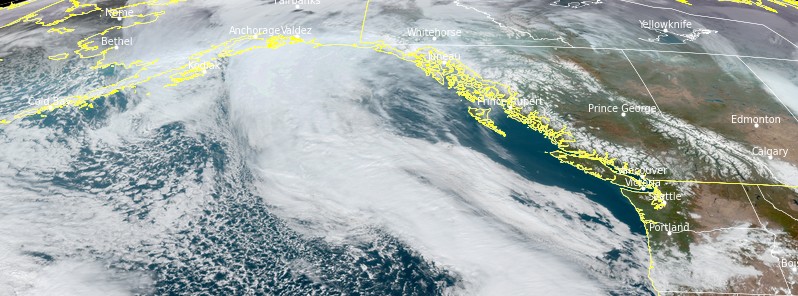
Image credit: NOAA/GOES-West. Acquired at 20:51 UTC on November 4, 2021
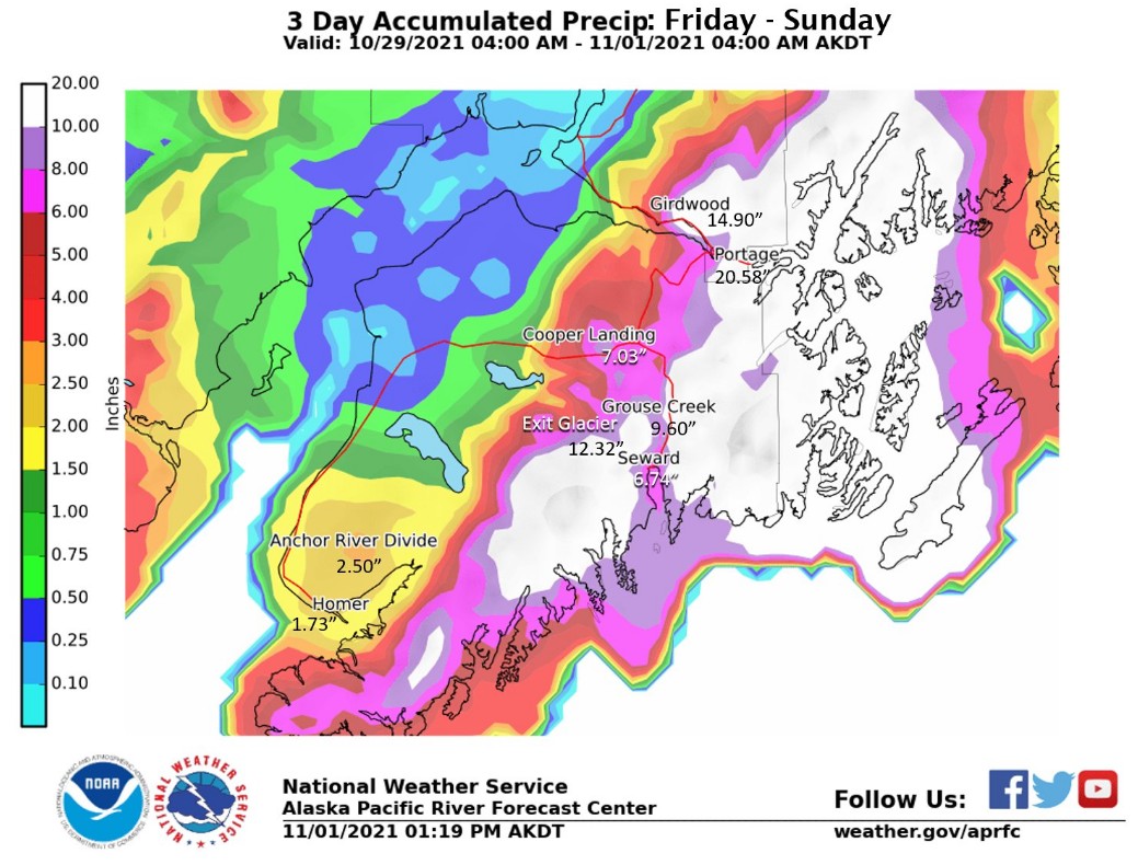
An atmospheric river impacted southern Alaska over the past couple of days, bringing prolonged heavy rainfall which resulted in historic rainfall totals. The rain began on Friday, October 29 and continued through November 3. Flooding was reported in Girdwood, near Alyeska while a landslide closed the Sterling Highway.
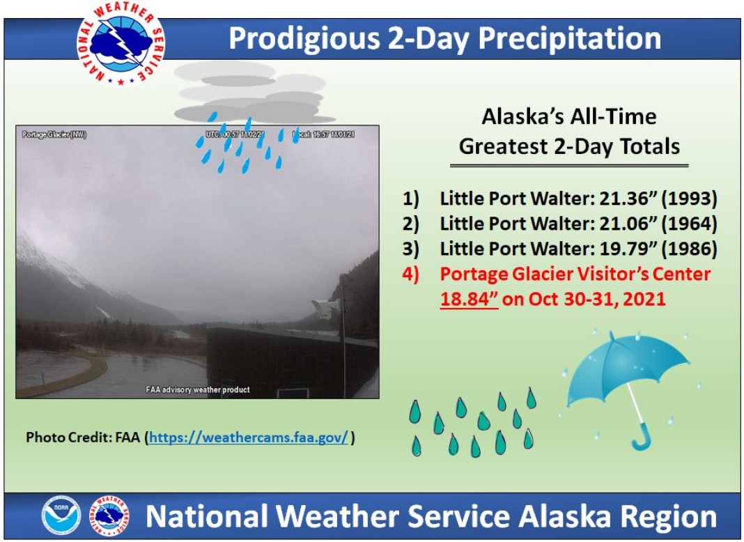
The Portage Glacier Visitor's Center, about 30 km (18 miles) SE of Girdwood observed historic rainfall totals, NWS Alaska Region said.
The area received 478.5 mm (18.84 inches) on October 30 and 31, 2021, making it their 4th greatest 2-day total.
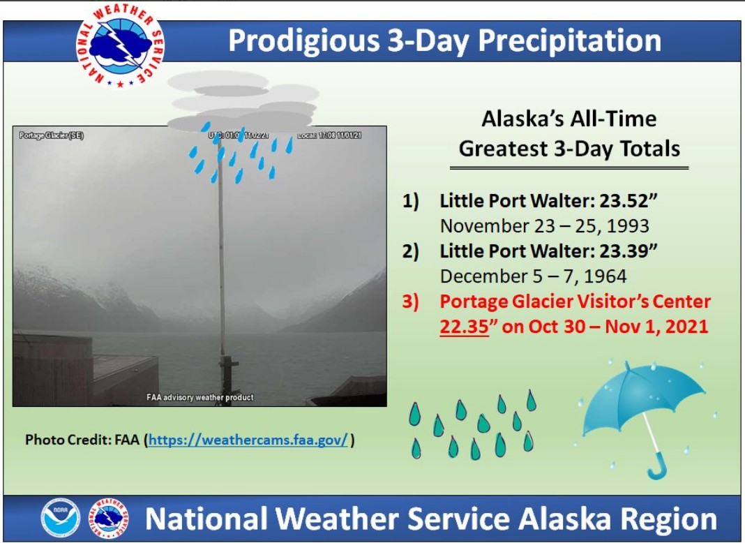
Another 76.2 mm (3 inches) fell there on November 1, bringing their 3-day total to 567.69 mm (22.35 inches). This marked their 3rd greatest 3-day total on record.1
"Girdwood and Portage absolutely crushed their all-time 1 and 2-day rainfall records. NOAA Atlas-14 estimated return intervals for these rainfall amounts were between 500 – 1 000 years," NWS Anchorage said.
From October 29 to November 3, Portage Lake Visitor Center ASOS registered 692.65 mm (27.27 inches) of rain, base of Alyeska COOP station 449.58 mm (17.70 inches), Alaska railroad at Portage 295.40 mm (11.63 inches), Snow River near Seward 270.76 mm (10.66 inches), Kenai Lake RAWS 234.69 mm (9.24 inches), Resurrection River at Exit Glacier 222.75 mm (8.77 inches), Alaska Railroad at Moose Pass 187.45 mm (7.38 inches) and Seward, AK 171.45 mm (6.75 inches).
"The recurrence interval of many of these values range from a 1 in 25 year record to a 1 in 1 000 year record event," NWS Anchorage said.
"The rainfall from Portage Lake Visitor Center represents the farthest north location in the United States to receive consecutive days of 203.2 mm (8+ inches) of rain. This represents the wettest 3 day period since records began in 1972, beating the previous record from 2011 by 155.19 mm (6.11 inches).2
NWS climate researcher Brian Brettschneider told KTOO this event was notable both for rainfall totals and the duration of the heavy rain.3
"There’s just a pipeline of moist air from the subtropics that was just funneled by atmospheric flow right into the northern Gulf coast and then it didn’t move," Brettschneider said.
"It wasn’t pushed along, you know, from east to west. And so the duration is really what’s noteworthy."
There were 12 – 15 mm (0.5 to 0.6 inches) of rain for hour after hour after hour after hour, Bretschneider said.
"Alyeska Resort cooperative station at the base had about 381 mm (15 inches) in a two-day period… an estimated recurrence interval of over 500 years, for two days."
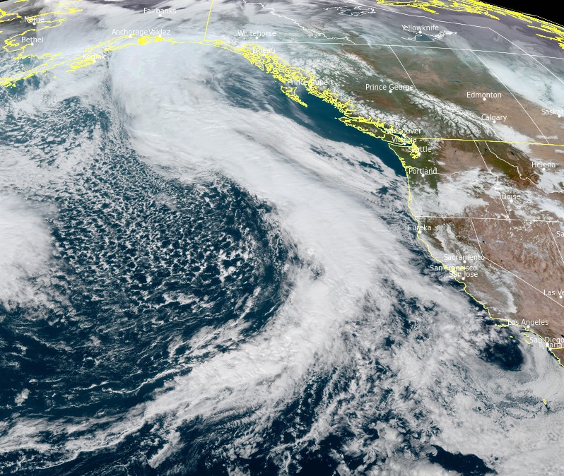
Image credit: NOAA/GOES-West. Acquired at 20:51 UTC on November 4, 2021
More unsettled weather is in store for the northwestern quadrant of the mainland U.S. as a parade of Pacific storm systems continues to move onshore, delivering more rain and high elevation snow from the coast to the Rockies, NWS said.4
The moisture-rich cold fronts associated with these systems could deliver as much as 25 – 50+ mm (1 – 2 inches) of rain to low-lying coastal areas from northern California to the Olympic Peninsula as well as some heavy snow to the Cascades during the next couple of days.
As the moisture moves further inland, light to moderate rain showers and the coincident high elevation snow will spread east into the northern Great Basin and the northern Rockies.
A lull in the activities is expected early on Saturday before the next stronger Pacific system edges closer, bringing with it another round of soaking rains and mountain snows.
Though precipitation totals are not expected to be as high as those with the previous system, a drop in snow levels will allow snow to accumulate at lower elevations throughout the Cascades and the Olympic Mountains.
References:
1 NWS Alaska Region
2 PUBLIC INFORMATION STATEMENT – NATIONAL WEATHER SERVICE ANCHORAGE AK 1202 AM AKDT THU NOV 4 2021
3 Ask a Climatologist: Unwavering atmospheric river soaked Southcentral Alaska – KTOO
4 Short Range Forecast Discussion – NWS Weather Prediction Center College Park MD 418 PM EDT Thu Nov 04 2021
I'm a dedicated researcher, journalist, and editor at The Watchers. With over 20 years of experience in the media industry, I specialize in hard science news, focusing on extreme weather, seismic and volcanic activity, space weather, and astronomy, including near-Earth objects and planetary defense strategies. You can reach me at teo /at/ watchers.news.
Keep the firewood dry!