
Super Typhoon “Chanthu” moving toward Philippines, Taiwan and China
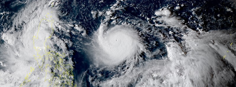
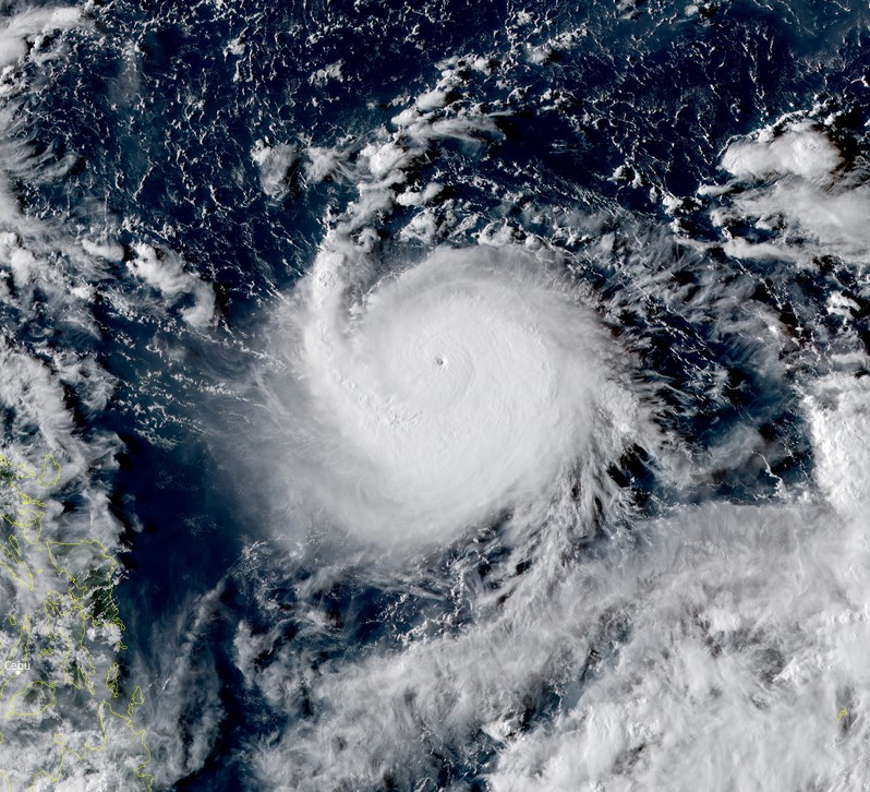
Featured image: Typhoon "Chanthu" at 07:40 UTC on September 8, 2021. Credit: JMA/Himawari-8, RAMMB/CIRA, TW
Chanthu reached a Category 5 super typhoon status at 09:00 UTC on September 8, 2021, becoming the second super typhoon of the year. In the Philippines, this tropical cyclone is known as Kiko.
At the time, Chanthu's center was located about 1 265 km (785 miles) SSE of Kadena Air Base, Japan. The storm had maximum 10-minute sustained winds of 175 km/h (110 mph), with gusts to 250 km/h (155 mph), and 1-minute sustained winds of 260 km/h (160 mph). The minimum central pressure was 940 hPa and the system was moving WSW at 19 km/h (12 mph).1
The maximum significant wave height at 06:00 UTC was 11.5 m (38 feet).
Chanthu is forecast to turn to a more westward track over the next 12 hours, and initial signs of this occurrence are already being seen in animated multispectral imagery (MSI) through 08:00 UTC, JTWC forecasters said at 09:00 UTC.2
After that, the subtropical ridge (STR) is forecast to move E resulting in a more SE-NW orientation along its southwest periphery, allowing the system to gradually turn more NW through 09:00 UTC on September 10, and enter the Luzon Strait by 09:00 UTC on September 11.
While global model fields show primarily zonal flow across central China, the orientation of the STR to the east and developing STR over southern China induce weakness in the ridge northwest of Taiwan, which will allow Chanthu to turn northwest after 09:00 UTC on September 11 and head towards a landfall along the southeast coast of China between 09:00 UTC on September 12 and 09:00 UTC on September 13.
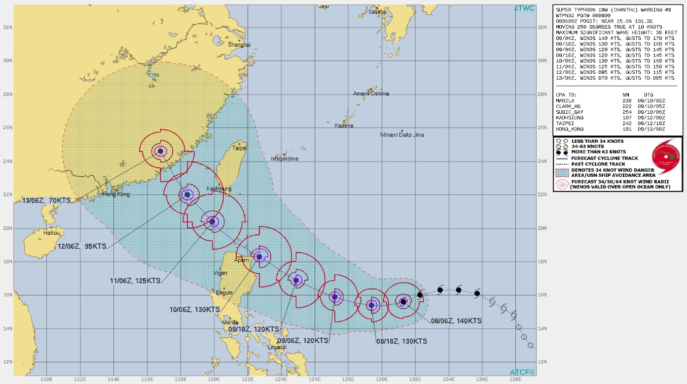
Super Typhoon "Chanthu" forecast track by JTWC at 09:00 UTC on September 8, 2021
While there is no Tropical Cyclone Wind Signal currently in effect in the Philippines, PAGASA warns heavy rains associated with the typhoon may begin affecting the eastern section of Northern Luzon on Friday."The public and disaster managers in these areas are advised to continue monitoring for updates and take appropriate preparatory activities."3
The current track and intensity forecast shows that there is a moderate to high likelihood that Tropical Cyclone Wind Signals (TCWS) will be hoisted for several provinces in Northern Luzon, with higher wind signal levels possible over Extreme Northern Luzon. These wind signals may be hoisted for these localities beginning tonight or tomorrow morning (LT). The highest possible wind signal that may be hoisted for this tropical cyclone is TCWS #4.
The public and disaster managers, especially those in localities of Northern Luzon are advised to monitor for updates in the coming days regarding the potential for coastal inundation due to the approaching typhoon.
In the next 24 hours, the typhoon is less likely to cause sea conditions over the coastal waters of the country which may pose threat to safety of lives at sea, especially for those using small sea vessels.
However, mariners are advised to continue monitoring for updates as rough sea condition may begin affecting the northern and eastern seaboards of Luzon beginning tomorrow as the typhoon closes in on Northern Luzon.
Due to the strength of this tropical cyclone, sea condition over the waters in the northern provinces of the country will likely be risky for all types of seacrafts in the coming days, PAGASA said.
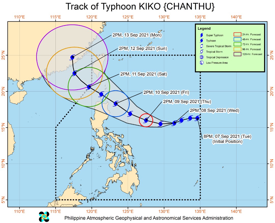
On the PAGASA forecast track, the typhoon is forecast to move westward southwestward in the next 12 hours before turning west northwestward until Friday making close approach over the northeastern section of mainland Cagayan before heading towards the vicinity of Extreme Northern Luzon.
"Afterwards, the typhoon will turn generally north northwestward and pass near the southern coast of Taiwan on Saturday before making landfall in the vicinity of southeastern China on Sunday evening or Monday morning," PAGASA said.
"The public is advised to continue monitoring for possible changes in the track forecast.
"Due to favorable environmental conditions, the typhoon is expected to continuously intensify until Saturday, when it is likely to reach its peak intensity of 185 to 205 km/h [115 – 130 mph] – while moving over Northern Luzon. Weakening is possible on Sunday as it moves closer to Taiwan and interacts with its rugged terrain."
Typhoon "Chanthu" at 07:40 UTC on September 8, 2021. Credit: JMA/Himawari-8, RAMMB/CIRA, TW
Forecast models
References:
1 Super Typhoon 19W (Chanthu) Warning #09 Issued at 08/0900Z – JTWC
2 WDPN32 PGTW 080900 – JOINT TYPHOON WRNCEN PEARL HARBOR HI – PROGNOSTIC REASONING FOR SUPER TYPHOON 19W (CHANTHU) WARNING NR 009
3 TROPICAL CYCLONE BULLETIN NO. 4 Typhoon “KIKO” (CHANTHU) Issued at 5:00 PM, 08 September 2021 – PAGASA
I'm a dedicated researcher, journalist, and editor at The Watchers. With over 20 years of experience in the media industry, I specialize in hard science news, focusing on extreme weather, seismic and volcanic activity, space weather, and astronomy, including near-Earth objects and planetary defense strategies. You can reach me at teo /at/ watchers.news.
Commenting rules and guidelines
We value the thoughts and opinions of our readers and welcome healthy discussions on our website. In order to maintain a respectful and positive community, we ask that all commenters follow these rules.