
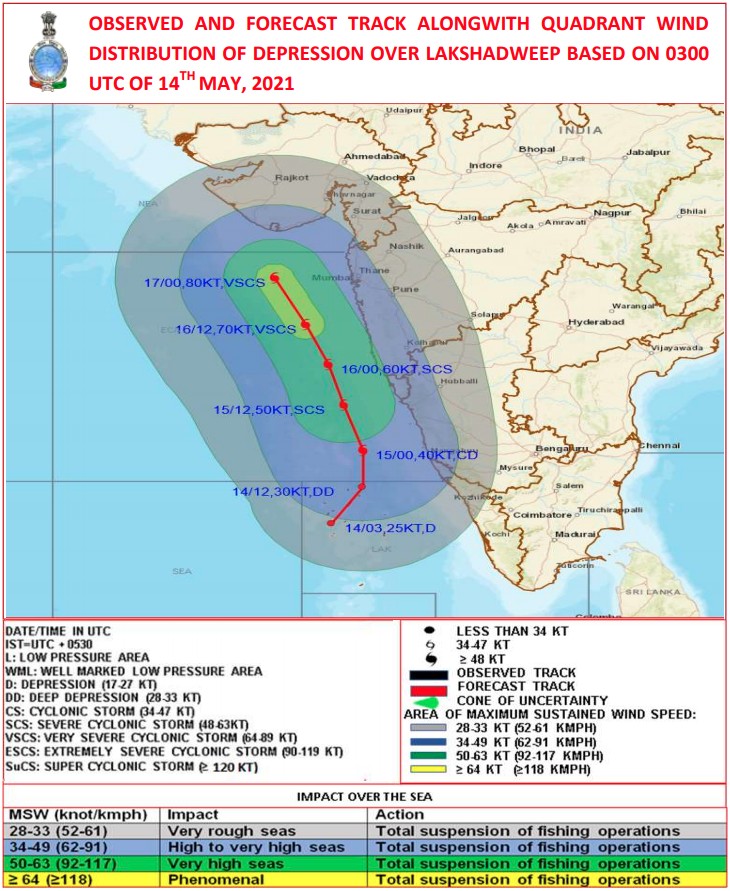
Depression over Lakshadweep area to intensify into a cyclone, move toward Gujarat coast and Pakistan
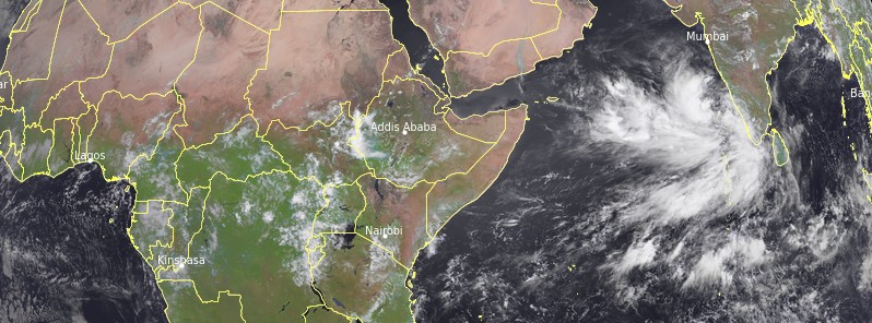
Featured image: Depression over the Lakshadweep, India at 08:15 UTC on May 14, 2021. Credit: EUMETSAT/Meteosat-8
A Pre-Cyclone watch has been issued for the coasts of south Gujarat and Diu after a well-marked LPA concentrated into a Depression over the Lakshadweep area. Heavy rainfall was already reported over areas of Kerala, with the IMD advising fishermen not to sail in the area. Parts of Kerala and Lakshadweep are placed under red alert. Forecast models show the cyclone will continue intensifying over the next 4 days and make landfall over Pakistan on May 19, bringing strong winds and heavy rain.
A well-marked low pressure area over Lakshadweep area and adjoining southeast Arabian Sea moved ENE, concentrated into a Depression and at 03:00 UTC on May 14 lay centered over Lakshadweep area about 80 km (50 miles) SSW of Amini Divi, 360 km (224 miles) WSW of Kannur, Kerala, 1 170 km (730 miles) SSE of Veraval, Gujarat.
It is very likely to intensify into a Deep Depression during the next 12 hours, into a Cyclonic Storm during the subsequent 12 hours, and continue intensifying, the India Meteorological Department (IMD) said.
It is very likely to move initially NNE until the evening of Friday, May 14. It would then move NNW and reach near the Gujarat coast by the morning of May 18 (LT).
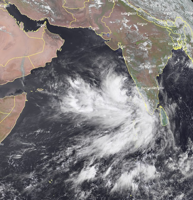
Depression over the Lakshadweep, India at 08:15 UTC on May 14, 2021. Credit: EUMETSAT/Meteosat-8
Warnings issued by IMD
Rainfall
Lakshadweep Islands:
Light to moderate rainfall at most places, with heavy to very heavy falls at a few places and extremely heavy falls (≥ 200 mm / 7.9 inches) at isolated places, is very likely on May 14. Heavy to very heavy falls are forecast at isolated places on May 15, and heavy falls at isolated places on May 16.
Kerala:
Light to moderate rainfall at most places, with heavy to very heavy falls at a few places and extremely heavy falls (≥ 200 mm / 7.9 inches) at isolated places, is forecast on May 1; heavy to very heavy falls at a few places on May 15, and heavy to very heavy falls at isolated places on May 16 and 17.
Tamil Nadu (Ghat districts):
Light to moderate rainfall at many places, with heavy to very heavy falls and extremely heavy falls at isolated places, is very likely on May 14 and heavy to very heavy falls at isolated places on May 15.
Karnataka (coastal and adjoining Ghat districts):
Light to moderate rainfall at most places, with heavy to very heavy falls at a few places with extremely heavy falls at isolated places, is expected on May 14 and 15 and heavy falls at isolated places on May 16.
Konkan and Goa:
Light to moderate rainfall at a few places, with heavy falls at isolated places very likely over Goa on May 14, at most places with heavy to very heavy falls at a few places over south Konkan and Goa and heavy to very heavy falls at isolated places over north Konkan on May 15 and heavy falls at isolated places on May 16.
Gujarat:
Light to moderate rainfall at many places, with heavy falls at isolated places, is very likely over coastal districts of Saurashtra on May 16, at most places with heavy to very heavy falls at a few places on May 17, and with heavy to very heavy falls at a few places and extremely heavy falls (≥ 200 mm / 7.9 inches) at isolated places over Saurashtra and Kutch on May 18.
Southwest Rajasthan:
Light to moderate rainfall at many places with heavy falls at isolated places is very likely on May 17 and 18.
Wind warning
Squally weather with wind speed reaching 45 – 55 km/h (28 – 35 mph) gusting to 65 km/h (40 mph) is very likely over the southeast Arabian Sea and adjoining Lakshadweep – Maldives area and the equatorial Indian Ocean on May 14. It is very likely to increase gradually to 50 – 60 km/h (31 – 37 mph), gusting to 70 km/h (44 mph) over the same region from the morning of May 14.
It is likely to increase gradually becoming Gale wind speed reaching 70 – 80 km/h (44 – 50 mph) and gusting to 90 km/h (56 mph) over the east-central Arabian Sea and adjoining southeast Arabian Sea and Lakshadweep area from the morning of May 15.
Squally wind speed reaching 45 – 55 km/h (28 – 35 mph), gusting to 65 km/h (40 mph) likely along and off Kerala coast on May 14 and 50 – 60 km/h (31 – 37 mph), gusting to 70 km/h (44 mph) along and off Kerala – Karnataka coasts on May 15.
Squally wind speed reaching 40 – 50 km/h (25 – 31 mph), gusting to 60 km/h (37 mph) are likely along and off south Maharashtra and Goa coasts on May 15; Gale winds speed reaching 60 -70 km/h (37 – 44 mph), gusting to 80 km/h (50 mph) along and off south Maharashtra – Goa coasts on May 16.
Squally wind speed reaching 40 – 50 km/h (25 – 31 mph), gusting to 60 km/h (37 mph) are likely over the northeast Arabian Sea and along and off south Gujarat and Daman and Diu coasts on May 17 morning; gradually increase, becoming Gale winds speed reaching 90 – 100 km/h (55 – 62 mph), gusting to 115 km/h (72 mph) over the northeast Arabian Sea along and off Gujarat coast from the early hours of May 18 and increase gradually thereafter until the morning of May 18.
Sea condition
Sea conditions over the southeast Arabian Sea and adjoining Lakshadweep – Maldives area and the equatorial Indian Ocean will be rough to very rough on May 14.
Sea conditions over the east-central Arabian Sea will be High to very High on May 15 and 16 and over the northeast Arabian Sea from May 17.
Sea conditions will be rough to very rough over the Comorin area and along and off the Kerala coast on May 14 and 15. Very rough to High over the east-central Arabian Sea along and off Karnataka coast on May 15 and Maharashtra – Goa coasts on May 15 and 16.
It is very likely to be very rough to High over the northeast Arabian Sea along and off south Gujarat coast from the morning of May 17 and very high to Phenomenal from the morning of May 18.
Tidal wave Warning:
A tidal wave of about 1 m (3.3 feet) height above the astronomical tide is very likely to inundate low-lying areas of Lakshadweep Islands on May 15 and 16.
Fishermen Warning:
The fishermen are advised not to venture into the southeast Arabian Sea, Lakshadweep – Maldives areas, the east-central Arabian Sea along and off Karnataka coast, the east-central Arabian Sea and along and off Maharashtra – Goa coasts, and into east-central and adjoining northeast Arabian Sea along and off Gujarat coast until May 18.
Those who are out at sea over north and adjoining east-central Arabian Sea are advised to return to the coast.
I'm a dedicated researcher, journalist, and editor at The Watchers. With over 20 years of experience in the media industry, I specialize in hard science news, focusing on extreme weather, seismic and volcanic activity, space weather, and astronomy, including near-Earth objects and planetary defense strategies. You can reach me at teo /at/ watchers.news.
Commenting rules and guidelines
We value the thoughts and opinions of our readers and welcome healthy discussions on our website. In order to maintain a respectful and positive community, we ask that all commenters follow these rules.