
Sudden increase in seismic tremor southwest of Keilir at Reykjanes Peninsula, Iceland
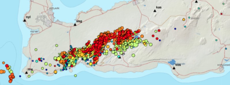
Image credit: IMO
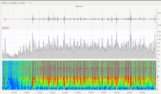
A sudden increase in seismic tremor was detected throughout most of Iceland's national seismic network at 14:20 UTC on March 3, 2021. Similar bursts of tremor have been observed ahead of previous volcanic eruptions in Iceland.
As of 19:00 UTC, the tremor continues although its intensity has reduced slightly, the Icelandic Met Office (IMO) reports.
The tremor, which comprises many small, overlapping earthquakes, is sourced from a region 2 km (1.2 miles) southwest of Keilir on the Reykjanes Peninsula.
Magma movements are a likely cause for the ongoing signal, and it is possible that an effusive (lava-producing) eruption could occur close to Keilir.
Analysis of various sensor and satellite-based monitoring data continues at pace, with further spaceborne radar images becoming available late this evening, IMO specialists added.
As a precaution for domestic and international air travel, the volcanic Aviation Colour Code for the Reykjanes Peninsula has been elevated from Yellow (elevated unrest) to Orange (heightened unrest).
The orange alert represents the third-highest level, with red reserved for an imminent or ongoing volcanic eruption.
Earlier today, IMO said their network has detected around 15 000 earthquakes in Reykjanes Peninsula since an intense earthquake swarm started on February 24, 2021.
By March 1, the number rose to over 10 000 and by March 3 it's already around 15 000, with quite a few over M4.0 and two over M5.0.
Most of the activity is confined to the vicinity of Keilir and Trölladyngja.
Geological summary
The Reykjanes volcanic system at the SW tip of the Reykjanes Peninsula, where the Mid-Atlantic Ridge rises above sea level, comprises a broad area of postglacial basaltic crater rows and small shield volcanoes.
The submarine Reykjaneshryggur volcanic system is contiguous with and is considered part of the Reykjanes volcanic system, which is the westernmost of a series of four closely-spaced en-echelon fissure systems that extend diagonally across the Reykjanes Peninsula.
Most of the subaerial part of the volcanic system (also known as the Reykjanes/Svartsengi volcanic system) is covered by Holocene lavas.
Subaerial eruptions have occurred in historical time during the 13th century at several locations on the NE-SW-trending fissure system, and numerous submarine eruptions at Reykjaneshryggur dating back to the 12th century have been observed during historical time, some of which have formed ephemeral islands.
Basaltic rocks of probable Holocene age have been recovered during dredging operations, and tephra deposits from earlier Holocene eruptions are preserved on the nearby Reykjanes Peninsula. (GVP)
I'm a dedicated researcher, journalist, and editor at The Watchers. With over 20 years of experience in the media industry, I specialize in hard science news, focusing on extreme weather, seismic and volcanic activity, space weather, and astronomy, including near-Earth objects and planetary defense strategies. You can reach me at teo /at/ watchers.news.
Yeah just like the last time when air travel in most of the world’s Northern Hemisphere was grounded for days.
Pity that Vega$ does not give odds on something happening there.
I’d lay 3 to 1 nothing much happens except a second rate volcano. That’s perhaps some magma and clouds going up to a few thousand feet; nothing very spectacular.